Home → Books & Videos → The User’s Manual
Your Land History: The User's Manual
How to Make and Read Your Own Property Report
Prepared by the Your Land History project. Edition 1.1, October 2026.
About this edition
This is the adult edition of the manual for the website Your Land History, version 1.1, written for someone who has never seen the site. It is the first edition; a Kids edition and a Professional edition may follow, made from this one. A companion book, Knowing Your Land: A Reference Guide to Researching Your Land's History, by Bob Zybach, explains the records behind every report; a table at the back of this manual matches each part of a report to its chapter.
Acknowledgments
Your Land History is a project of Dr. Bob Zybach and Dr. Dave Sullivan. The research method comes from Oregon Websites and Watersheds; the idea began in the library of Oregon Advocates for School Trust Lands. Both are thanked here, because what the site knows how to look for comes from their work.
Every report is built from public records kept by the Bureau of Land Management, the U.S. Geological Survey, the Natural Resources Conservation Service, the National Oceanic and Atmospheric Administration, the Oregon Department of Geology and Mineral Industries, the Oregon State Archives and Oregon's county offices. Their records are open to everyone, which is why the site can exist.
Contents
Who this manual is for
The example in this manual
Before you start
Part 1. Making your report
Part 2. Reading your report
- The opening and "This land today"
- The record behind every sentence
- The ground
- Water and weather
- The people before the surveyors
- The surveyors arrive
- First owners
- The families
- Seen from above
- Getting here
- Timeline
- If you're hooked: what to do next
- About this report: the appendix
Part 3. Doing more
- Detail and Written for
- Look deeper into this
- Everything we can look for
- My research list
- Printing a report and saving it as a PDF
- Copy my link
- My land, Forget this land and Larger text
Part 4. When something goes wrong
Part 5. Questions people ask
At the back
The words used · Where to read more in Knowing Your Land · About this manual
Who this manual is for
In March 1854 a government surveyor walking a section line near Pedee, Oregon, wrote four words in his notebook: "Leave prairie & enter Timber."1 Anyone can still read that notebook, and the map drawn from it, and the paper that passed the land to its first private owner. Your Land History gathers records like these for one piece of Oregon land and writes them up as a story you can follow. This manual shows you how.
It was written with three readers in mind.
The landowner with a tax statement. You own a house lot, a farm or a woodlot, and you want to know what was there before you. Your tax statement holds everything you need to start ("Before you start" shows where).
The family member with a story. Your family has always said that great-grandfather homesteaded the place, or that the old barn stood on a pioneer's land claim. You want to see whether the records agree. Sometimes they do. On the land that runs through this manual, they did not: the farm's own management plan said "homesteaded," and the records said that homesteading accounts for about 7 of its 211 acres.2
The student with a schoolyard. Your class wants to know what the ground under the school looked like before the town was there. The school's address, or its township, range and section, is enough.
You may be reading on a phone, in a field or a county office, and you may prefer large type. The site was designed for that. Every button works with one thumb, and Larger text makes the words bigger. On a wide screen it is at the top of every page; on a phone, touch Menu, then Larger text.
How to read this manual. Part 1 takes you from the front page to a finished report. Part 2 walks through a finished report, part by part. Part 3 covers the controls for doing more, Part 4 what to do when something goes wrong, and Part 5 the questions people ask most. Read it in any order.
Words you see on the screen are printed here in bold, spelled exactly as the site spells them, like Find my land. Messages the site shows are printed in quotation marks. Where a message includes your own numbers or names, this manual shows the place where they go in square brackets, like "Township [number] [North or South]."
The example in this manual
Almost every example in this manual comes from one real place: the Sullivan tree farm near Pedee, at 12875 Kings Valley Highway in Polk County. It is about 211 acres of Douglas-fir in the Coast Range foothills, in Sections 28 and 33 of Township 9 South, Range 6 West, Willamette Meridian. Dave Sullivan has owned it since December 1989.3 It is also the site's public sample report, which anyone can open from the front page.
We use it for a plain reason. Researching this farm's history with Bob Zybach, in October 2026, is what gave us the idea for the whole site. In the software business, using your own product on your own work is called "eating your own dog food." That is why the farm appears on nearly every page of this manual.
The farm is ordinary in the best way. It has the records much western Oregon land has: survey notes from the 1850s, two pioneer land claims, railroad grant land, a small homestead, aerial photographs from 1936 on, and gaps that only a trip to the county will fill.4 Where the manual says "In the sample report," it is showing you what the site found for this farm, and every fact in that box can be found on the sample's own pages. A few boxes are headed "From the farm's own history (not in the sample report)." They add what was found by hand, beyond the report; Knowing Your Land, Chapter 22, tells that longer story.
The sample is the same for everyone, so it has none of the buttons that appear only on reports you make yourself. The few pictures of those buttons, and of a report while it builds, show an area history made for this manual of the farm's own main section, Section 33, Township 9 South, Range 6 West. Most of that section lies inside two 1850s land claims, so the site outlined the parts of it outside them, about 185 acres, and wrote the history of that ground.
Before you start
Most Oregon land can be found from one line of a property tax statement. You need one of three things, and you probably have at least one of them in a drawer.
Three ways to say where your land is
| What you have | What it looks like | Where it is printed |
|---|---|---|
| Legal description | "The SE¼ of the NW¼ of Section 33, Township 9 South, Range 6 West, Willamette Meridian," or a claim or lot by number | Your deed. Title papers from when you bought the land. Sometimes in short form on the tax statement, like "Sec 33 T9S R6W." |
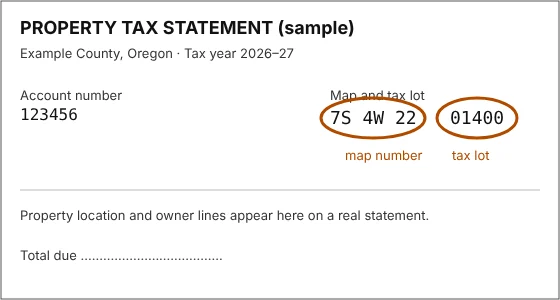
| Tax lot | A county, a map number like "7S 4W 22," and a tax lot like "01400" | Your property tax statement, usually near the top. The labels differ from county to county. Look for words like "map and tax lot" and "map/TL." The statement's account number is not used yet. |
| Street address | "123 Main Street, Monmouth, Oregon" | Anywhere. It works best in town. Farm and timber land often has no street address the federal address list knows. |
These examples are made up, except the township, range and section in the legal description, which are the sample farm's.
If you have more than one, use the legal description or the tax lot. They find your land itself; a street address finds a point, and the site writes about the land around it.
If you have none of them, ask the county assessor's office, or use your county's free property search online, or Oregon's statewide tax-map viewer, ORMAP. Or find your land on a map (Chapter 1).
What it costs
Nothing. There is no account to open, no payment and no email address to give. An office or archive that you visit later, following the report's suggestions, may charge for its own copies.
What else you need
A phone, tablet or computer with a web browser. There is nothing to install. The site works on slow country connections, though pictures take longer.
What the site does not do
The site tells the history of a piece of land. It does not search titles, survey boundaries or put a value on land. For who owns the land today and where its legal lines run, ask a title company or a licensed land surveyor; for what it is worth, ask an appraiser. Old records can explain a great deal about a property, but they cannot settle a dispute about it.
Notes
- Daniel Murphy, field notes of the section lines, Township 9 South, Range 6 West, Willamette Meridian, March 1854. Bureau of Land Management, Oregon land records, volume R0029, page 331. Murphy wrote "prarie." ↩
- A History of the Land: The Story of the Sullivan Tree Farm near Pedee, Polk County, Oregon (October 2026), opening and "1871 to 1900: Railroad land and a seven-acre homestead." ↩
- A History of the Land (2026), "The land today." ↩
- A History of the Land (2026), "1855: Two claims and two houses," "1871 to 1900" and "The twentieth century, seen from the air." ↩
Chapter 1. Finding your land three ways
Part 1. Making your report.
Making a report takes three steps: say where your land is, check the outline the site draws, and let the site gather and write. You type a few numbers and answer one question. The rest is reading.
Start here: five steps
- Go to the site. Open the web browser on your phone, tablet or computer, type YourLandHistory.org in the bar at the top, and press Enter or Go.
- Have one thing in hand. Your property tax statement is best; your deed also works. With neither, you can find your land on a map.
- Choose one of the three ways in under "Where is your land?": Legal description, Tax lot or Street address. For the sample farm you would touch Tax lot, choose Polk from the county list, type the map number 9S 6W 33 and the four tax lots 200, 206, 207, 304, and touch Find my land.
- Check the outline. The next page shows the land outlined in yellow on an air photo and asks "Is this your land?" If it is, touch Yes, make my report.
- Read as it arrives. The report starts at once, and each part appears as soon as it is written. The area history made for this manual took about two minutes; a township's first report takes longer. You can leave and come back with the report's link.
The quickest way to find a piece of Oregon land is the way the government first described it in the 1850s: by township, range and section, on the grid of squares the surveyors laid over the whole state. The front page asks for those numbers first, and offers two other ways in for anyone who does not have them.
The front page
The front page asks one question: "Where is your land?" Its heading reads "Every piece of land has a story. This is how you find yours."
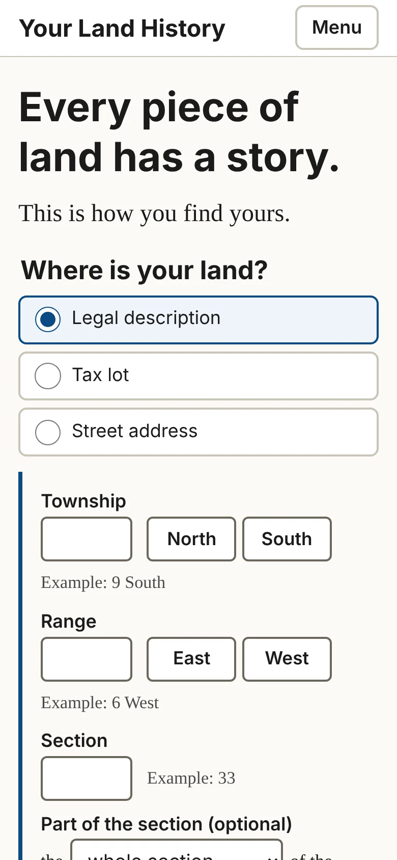
Under the question are three choices: Legal description, Tax lot and Street address. On a wide screen they are tabs across the top of a box; on a phone they are stacked buttons, and the one you choose opens beneath itself. Legal description is open when the page arrives.
Below the box are:
- a line that reads Don't have any of those? Find it on a map., for anyone without numbers;
- a link to the finished sample report, See a sample report: the Sullivan tree farm near Pedee, Oregon;
- four lines under the heading "What a report can show you," each a link to the part of the sample that shows it: the government's first survey map of your township, the trees the surveyors marked at your land's corners, who first got the land from the United States, and the people who lived there before the surveyors;
- under them, See everything a report can look for ›, which opens the full menu of topics (Chapter 20).
The header at the top of every page holds Your Land History (back to the front page), Sample report, How this works, The books, My land and Larger text. On a phone it shrinks to the site's name and a Menu button; touch Menu for the same links, Larger text among them. The foot of every page names the people behind the site and links to How this works, The books, Everything we can look for and About.
Three of those pages are about the site itself. How this works opens with the cedar post that surveyors set on a ridge west of Portland on June 4, 1851, from which every township in Oregon and Washington is counted, and then lists the five steps by which a report is made. The books offers this manual and Knowing Your Land, both free to read on the site. About says who is behind Your Land History and why the sample is a tree farm near Pedee, and gives the address for corrections, additions and questions: drdavesullivan@gmail.com.
Way one: the legal description
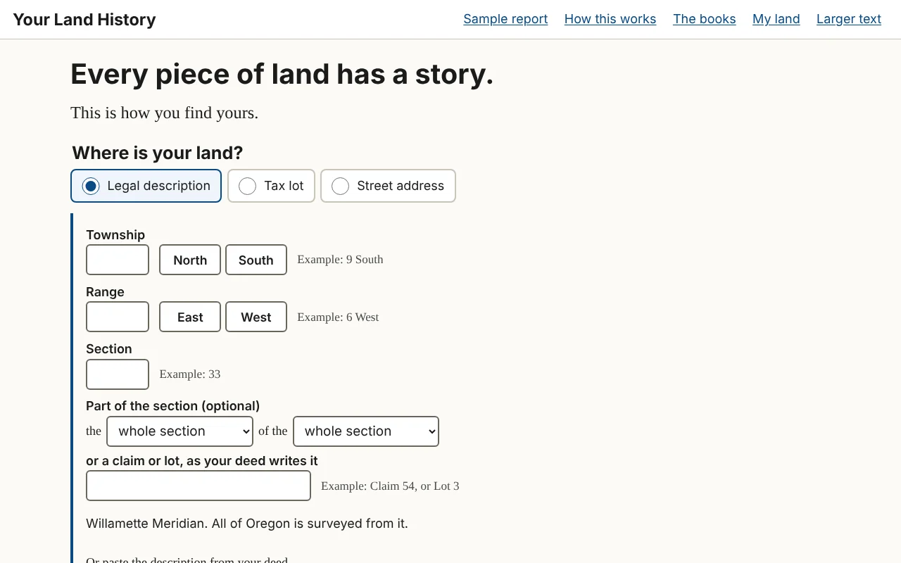
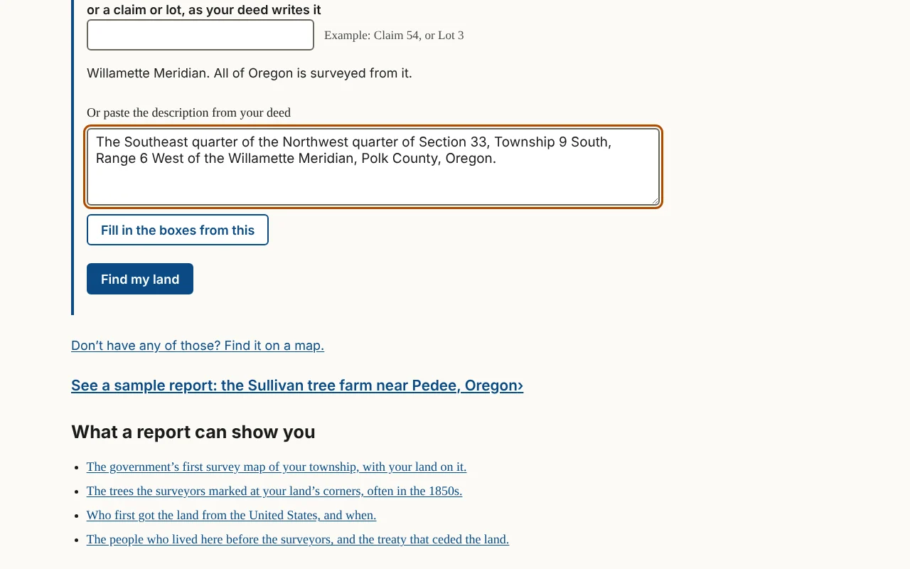
A legal description names land by its place on the survey grid. Read it from the end back: "The SE¼ of the NW¼ of Section 33, Township 9 South, Range 6 West" means the township, then Section 33, then its northwest quarter, then the southeast quarter of that. The box has these parts.
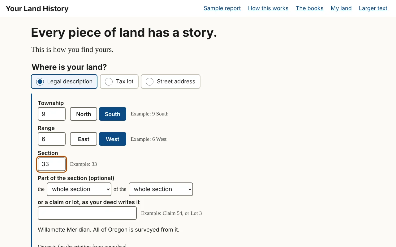
- Township. Type the number, then touch North or South. Example: 9 South. A township is a block of land six miles on a side; "9 South" is the ninth row of blocks south of the base line that crosses Oregon at Portland.
- Range. Type the number, then touch East or West. Example: 6 West. A range is a column of townships, counted from the Willamette Meridian, the north-south line through Portland.
- Section. Type a number from 1 to 36. Example: 33. Each township holds 36 sections, each about a mile square, or 640 acres.
- Part of the section (optional). Two drop-down lists that read as a phrase, "the [ ] of the [ ]," each offering the whole section or one of its four quarters. Choose only the second for a quarter section of 160 acres; choose both for a quarter of a quarter, 40 acres. For the description above, choose "southeast quarter," then "northwest quarter."
- or a claim or lot, as your deed writes it. A text box for land described by a pioneer's land claim or a numbered lot instead of quarters. Example: Claim 54, or Lot 3.
Under the boxes is one plain line: "Willamette Meridian. All of Oregon is surveyed from it." There is no choice of state or meridian to make.
If your deed's description is hard to break apart, use Or paste the description from your deed, a link under the boxes. Paste or type the deed's words into the box it opens, then touch Fill in the boxes from this. The site fills in what it can find, keeps your words beside the boxes, and says "We filled in the boxes from what you pasted. Please check each one." Check them.
When the boxes are filled, touch Find my land.
On a phone, the number boxes bring up the number keypad, and North, South, East and West are large buttons, so you never type a letter.
In the sample report
The Sullivan tree farm lies in Sections 28 and 33 of Township 9 South, Range 6 West. To find its main section, you would type 9 and touch South, type 6 and touch West, and type 33. Typing "Claim 54" in the claim box instead would outline the whole of Donation Land Claim 54, one of the two 1850s land claims the sample names.1
Way two: the tax lot
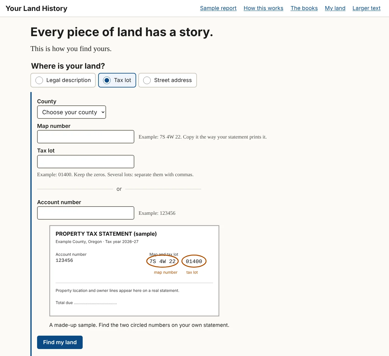
Every Oregon tax statement prints the numbers this box needs.
- County. A list of Oregon's 36 counties. Choose yours.
- Map number. Example: 7S 4W 22. Copy it the way your statement prints it.
- Tax lot. Example: 01400. Keep the zeros. Several lots: separate them with commas.
- a divider line reading "or"
- Account number. Example: 123456.
Give the map number and the tax lot. The account number is not used yet: given by itself, it brings the answer "We can't look up land by account number yet. Use the map number and tax lot printed on the same statement, or your legal description." A small sample statement beside the boxes shows where the numbers are printed.
Reading a map number. An Oregon tax map number is built from the survey grid. The sample farm's map number, "9S 6W 33," means Township 9 South, Range 6 West, Section 33. Letters after the section number name a quarter of the section. Some statements print the number without spaces, as "09S06W33." Copy it as printed, letters and all.
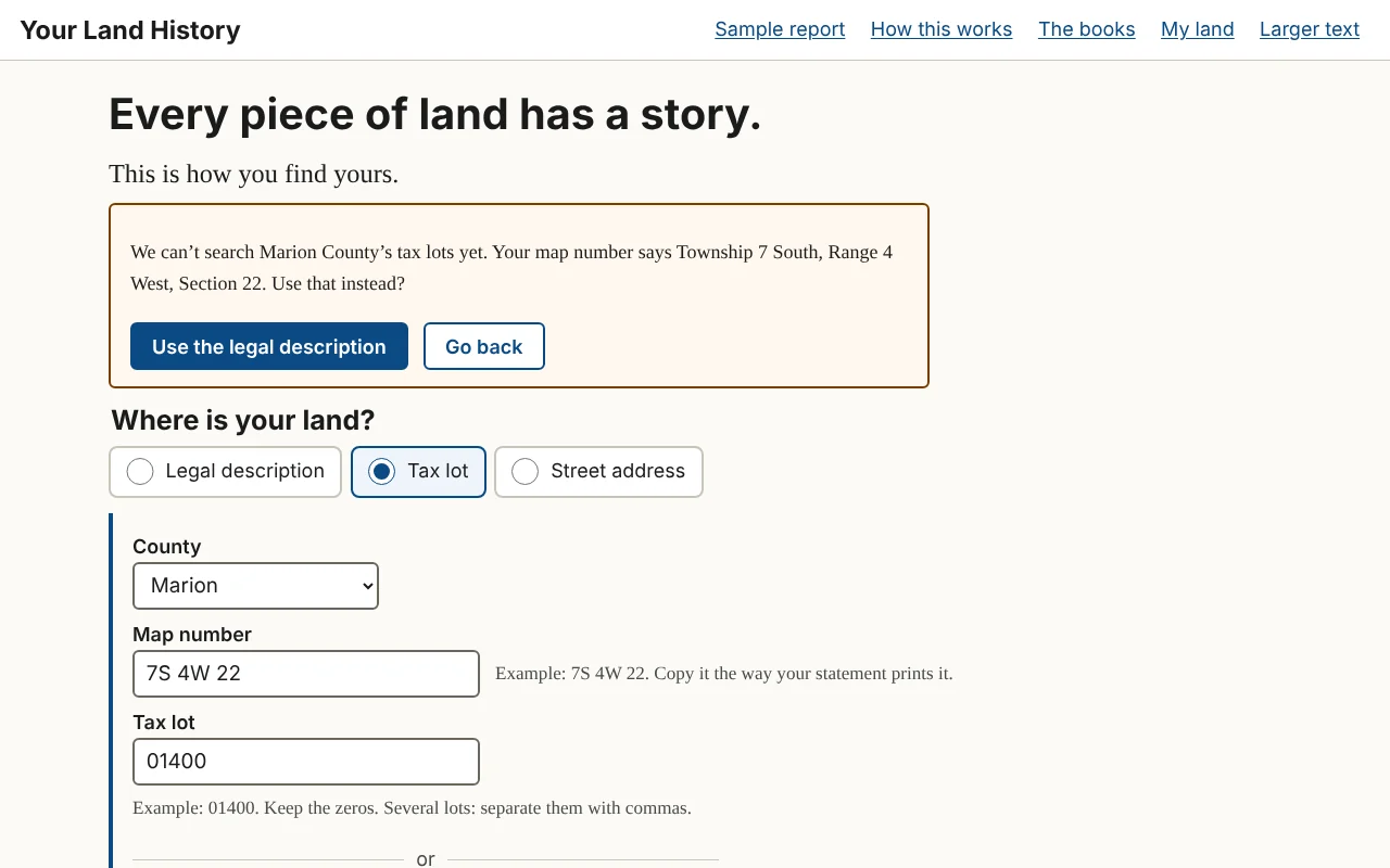
If the site can search your county's tax lots, it draws the lots' own outline for you to check. In this version that is Polk County. For other counties it reads the township, range and section out of your map number and offers them instead:
"We can't search [county] County's tax lots yet. Your map number says Township [number] [North or South], Range [number] [East or West], Section [number]. Use that instead?"
Touch Use the legal description to go on with those numbers, or Go back to change what you typed. The report will cover the whole section, which includes your lot (Chapter 2).
In the sample report
The sample was made this way: county, Polk; map number, 9S 6W 33; tax lots, "200, 206, 207, 304," the farm's four lots. They were typed without leading zeros, and the site still found them; copy yours as your statement prints them.2
Way three: the street address
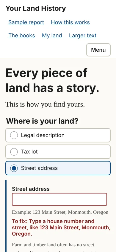
The Street address box has one line. Type a house number and street, like "123 Main Street, Monmouth, Oregon." Under it is a warning worth reading: "Farm and timber land often has no street address. If yours doesn't, use your tax lot."
The site looks the address up in the Census Bureau's address list. If there are several matches, the page asks "Which one is yours?" and shows up to eight as buttons. An address finds a point, not a lot, so the report it makes is an area history: the history of the land around that point. To get your own lot, use your tax lot.
The address you type is never printed on the report and never becomes its name. Such a report is named "Land in [county] County," and you can rename it.
No numbers at all: find it on a map
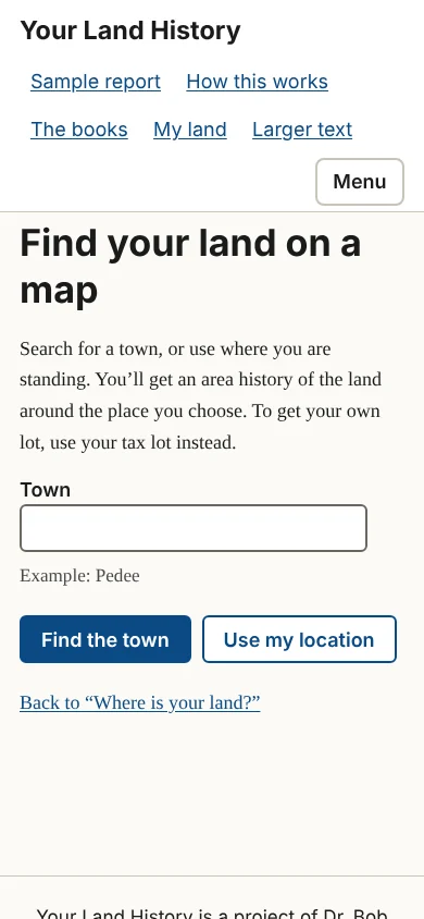
Touch Don't have any of those? Find it on a map. to open "Find your land on a map." There are two ways to use it.
- Type a town into the Town box and touch Find the town. Up to eight matches appear as buttons. Choose one.
- Touch Use my location, and let your browser tell the site where you are. This is the easiest way in if you are standing on the land with a phone. The button appears only where the browser offers it.
Either way you get an area history of the land around that place. To get your own lot, use your tax lot instead.
When something you typed needs fixing
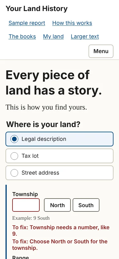
If a box is empty or a number cannot be right, a short message beginning "To fix:" appears next to that box (Figure 1.9). Nothing you typed is cleared. Chapter 25 lists every message, word for word, with what to do.
When your township is new to the site
The first search in a township takes longer, because the site fetches the township's survey grid; later searches there are faster. If the site cannot make a report in that township yet, it says: "We can't make a report in Township [number] [North or South], Range [number] [East or West] yet. Its survey records have not been gathered. The sample report shows what a report holds." Chapter 25 says what to do.
The sample report
See a sample report: the Sullivan tree farm near Pedee, Oregon, on the front page, and Sample report, in the header, both open the finished sample. Opening it builds nothing and changes nothing. Part 2 walks through it.
Notes
- A History of the Land: The Story of the Sullivan Tree Farm near Pedee, Polk County, Oregon (October 2026), "The land today" and "1855: Two claims and two houses"; Partition Plat No. 1993-0029, June 24, 1993, Polk County survey CS 12769. ↩
- The sample report, made October 10, 2026, from Polk County map 9.6.33, tax lots 200, 206, 207 and 304; A History of the Land (2026), "December 1989 to today," which names the farm's lots. ↩
Chapter 2. Checking the outline
Part 1. Making your report.
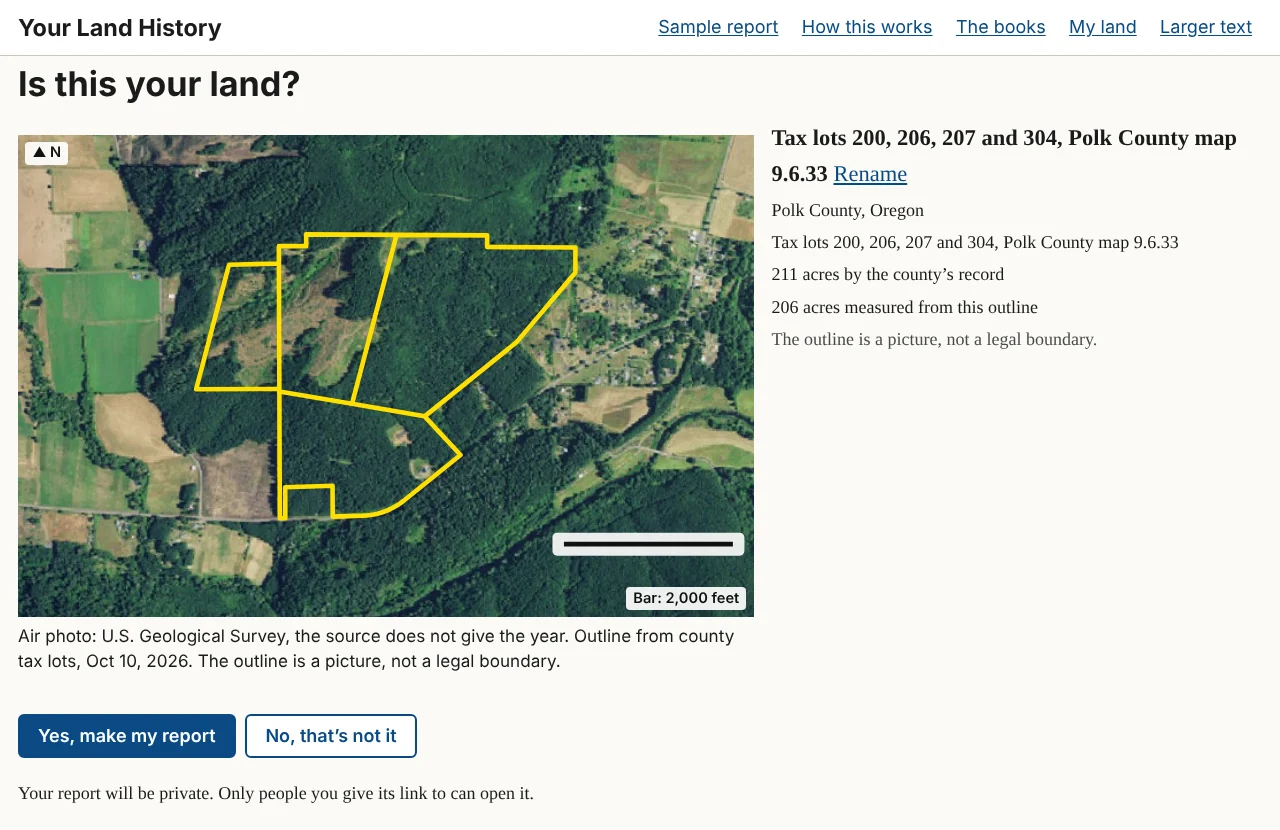
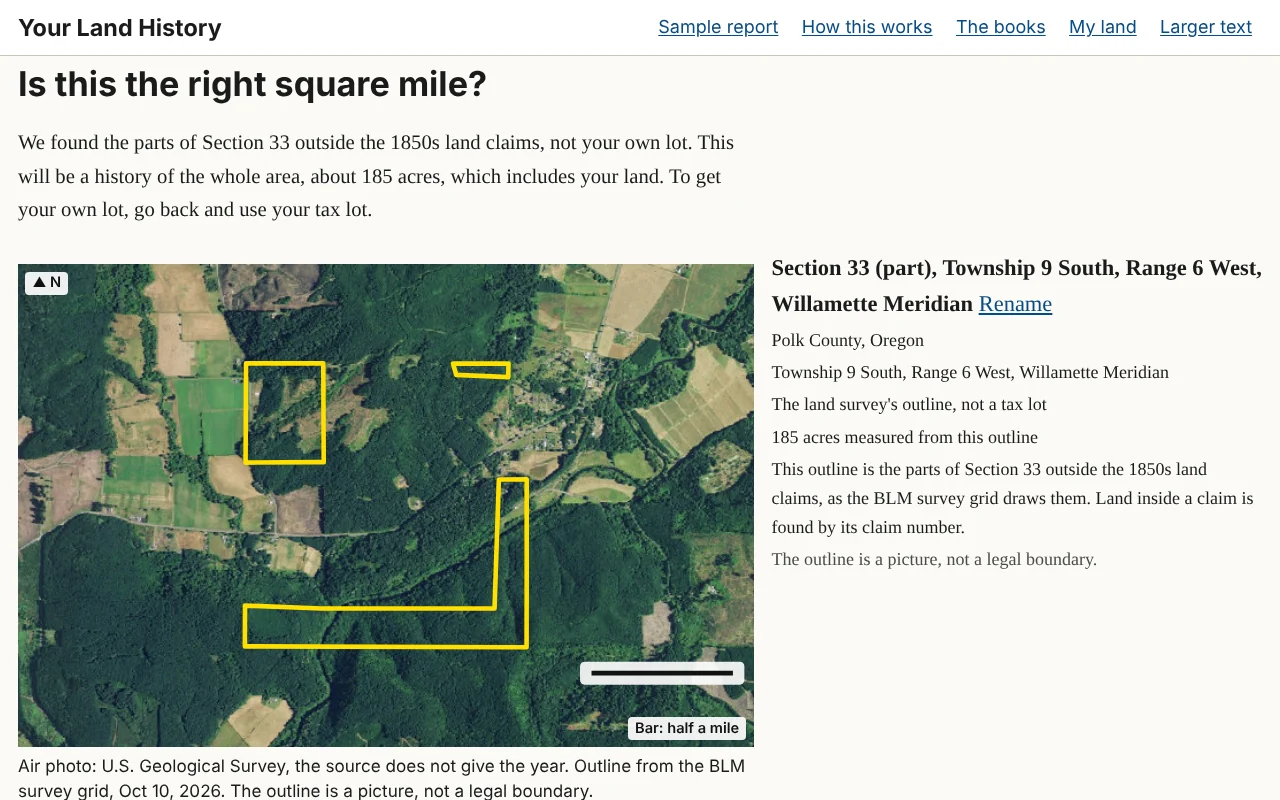
The next screen asks one question, in large type: "Is this your land?" It is the only thing between your numbers and your report, and it is worth a careful look, because the report will be about whatever the outline encloses.
What the screen shows
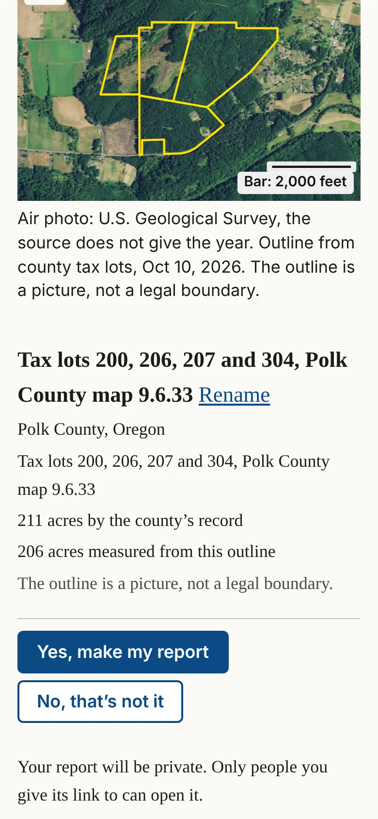
The picture is an air photo with an outline in yellow, a north arrow and a scale bar, and a line naming the photo's source and year. Beside it are:
- the name the report will carry, with Rename beside it;
- the county and state;
- the legal description, written out in full words (for tax lots, the lot numbers and the county's map number);
- the acres, shown two ways when both are known: "by the county's record" and "measured from this outline."
If the two acre figures differ by more than a tenth, one more line explains: "The two figures differ by [number] acres. Old surveys and modern maps rarely agree exactly; the county's figure is the one on your tax statement." A reminder follows: "The outline is a picture, not a legal boundary."
How to check it
Look for something you know: a road, a creek, a field edge, a clearing. Follow the yellow line around and ask whether it goes where your fence or your tax map says it should. Compare the acres with your tax statement. A few acres' difference is normal; half, or an outline on the wrong side of the creek, is not.
In the sample report
For the Sullivan tree farm the screen reads "211 acres by the county's record" and "206 acres measured from this outline." Neither figure is wrong. One is the county's record for taxes; the other is a measurement of lines drawn on a map. That is why the site shows both and says where each comes from.1
The two answers
- Yes, make my report starts the report at once and takes you to it.
- No, that's not it takes you back to the front page with every box as you left it, except a street address, which the site never keeps.
Under the buttons is one line about privacy: "Your report will be private. Only people you give its link to can open it."
On a phone the buttons stay at the bottom of the screen, with Yes, make my report on top.
Naming the report
Touch Rename to open a box with the current name and a Save button. Choose a name you will recognize later in My land. Until you change it, a report made from a legal description is named for its square, such as "Section 33, Township 9 South, Range 6 West, Willamette Meridian"; one made from a tax lot is named for its lots and map, such as "Tax lots 200, 206, 207 and 304, Polk County map 9.6.33"; and one made from an address is named "Land in [county] County." The sample is named "The Sullivan tree farm near Pedee."
When the site can only find the square mile
When the site can find the section but not your piece of it, or you came in by address or map, the heading becomes "Is this the right square mile?" and a paragraph says what the report will cover:
"We found Section [number], not your own lot. This will be a history of the whole area, about [number] acres, which includes your land. To get your own lot, go back and use your tax lot."
Where part of the section lies inside 1850s land claims, the site outlines only the parts outside the claims, and the paragraph begins "We found the parts of Section [number] outside the 1850s land claims." A line beside the picture adds: "Land inside a claim is found by its claim number." To make a report on a claim itself, go back and type its number in the claim box.
For a street address or a place on the map, the first sentence reads "We found the place, not your lot. This will be a history of the land around it, about [number] acres."
The buttons become Yes, make the area history and No, that's not it.
An area history is often nearly as good as a report on your own lot, because much of the early record was made section by section anyway. What it cannot do is say which part of the section is yours, and its first owners will include everyone who got land in that square mile.
Land outside Oregon
Washington is surveyed from the same meridian as Oregon, so a slip in the township number, or North chosen for South, can put the outline across the Columbia River. If the outline on "Is this your land?" is not where your land is, touch No, that's not it and check the township, the range and the North or South and East or West choices.
Notes
- The sample report, "This land today," October 10, 2026, from Polk County tax lots. ↩
Chapter 3. The report as it builds
Part 1. Making your report.
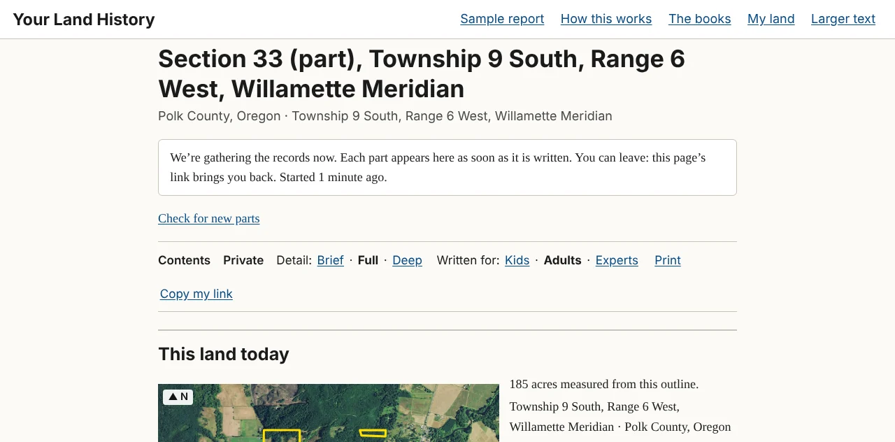
When you touch Yes, make my report, the site takes you straight to your report's own page. It looks like the finished report from the first moment; its parts fill in where they stand, and nothing jumps around as they arrive.
What appears first
The land's name, its place line and "This land today" appear first, because the site already knows them from the outline you checked. Under the place line is the waiting line:
"We're gathering the records now. Each part appears here as soon as it is written. You can leave: this page's link brings you back. Started 1 minute ago."
The minutes are the only number on that line, because they are the only one the site knows for sure. It does not guess how long your report will take. A township's first report takes the longest.
The four states of an unwritten part
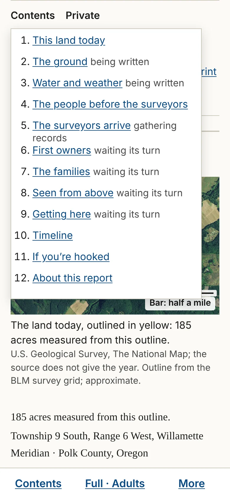
Below "This land today" are the eight parts of the story, in order. Until a part's paragraphs exist, it shows one of four lines under its heading.
| What you see | What it means |
|---|---|
| "Waiting its turn." | The site has not started gathering records for this part yet. |
| "Gathering records: [what], [source]." | A search for this part is running. The line names what is being looked for, in the same plain words as the report's headings, and where it comes from. |
| "Being written." | Every record for this part is in, and its paragraphs are being written from them. |
| "Not finished." | A search stopped. One plain sentence says why, with a Try again button. |
A part shows its paragraphs, pictures and records only when its paragraphs exist. Until then it shows only its line.
The opening, the one to three sentences at the very top of the finished report, is written last, from sentences already written further down.
Following along
The browser tab counts the parts as they are written: "[number] of 8 parts written · Your Land History." When the report is finished, the tab shows the land's name instead.
On a phone, touch Contents in the bar at the bottom of the screen to see the list of parts with the state of each one.
If you use a screen reader, it says "[Part] is written." once for each part as it arrives, and stays quiet the rest of the time.
If your browser has scripts turned off, the page cannot update itself. A link under the waiting line, Check for new parts, reloads the page to the same place.
How long it takes
That depends on how many records the land has, how quickly the sources answer, and whether anyone has made a report in that township before. You do not have to watch. Touch Copy my link and keep the link, or find the report later under My land in the same browser. When you come back, the page picks up where it is.
When a part is not finished
Two sentences can appear at the end of a part.
- "One source did not answer today: [source]. The rest of this part is here." A website the site depends on was down or slow. Touch Try again, now or later.
- "We stopped this part before it was finished. What we found is kept." Each report has an allowance of searching and writing, and this part reached it. Touch Try again to go on.
When a search simply finds nothing, the body says nothing about it; the appendix records the search.
When the page seems stuck
If nothing on the page has changed for ten minutes, reload it. Your report is not lost: its link always brings back whatever has been gathered and written so far. If a part still says "Not finished," touch Try again. If nothing helps, close the page and come back in an hour. Chapter 25 has more.
Chapter 4. Your report arrives
Part 1. Making your report.
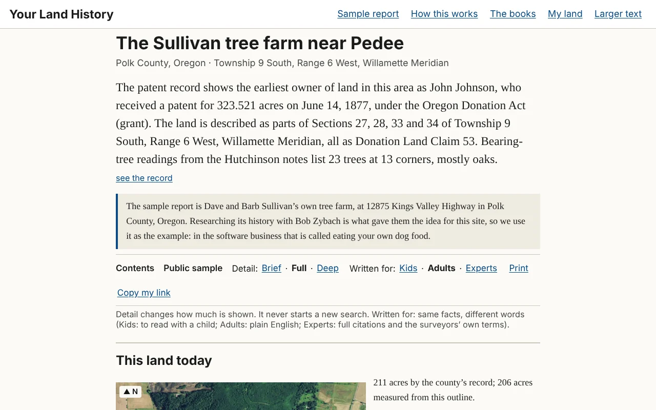
There is no announcement. The waiting line at the top disappears when the last part is written, the browser tab changes to the land's name, and the opening appears above "This land today": one to three sentences, in larger type, telling the most interesting thing the records hold about your land.
Five things to do first
- Read the opening. Every sentence in it is repeated further down, with its record.
- Keep the link. Touch Copy my link and email it to yourself. There are no accounts, so the link is how you get back from another phone or computer.
- Read "This land today," the land as it is now.
- Touch a small raised number after any sentence to open the record behind it (Chapter 6).
- Read "If you're hooked: what to do next," where to go for more, and what to bring.
The word "Private" near the top means only someone with the link can open the report. It is also listed under My land in this browser. The sample shows Public sample in the same place, because anyone may open it.
Chapter 5. The opening and "This land today"
Part 2. Reading your report.
A report reads like a short local history of one piece of land. It opens with the most interesting true thing the records hold, shows the land as it is today, and then tells its story from the beginning, from the rock underneath to the roads. A timeline gathers the dates. Then come the next steps, and at the very back an appendix that says what was searched and how sure the report is.
Every part opens with its most interesting record and ends with a closed block, "The record says," and a button, Look deeper into this. This Part walks through the report in order, using the sample report for the Sullivan tree farm near Pedee, with a box called "In the sample report" in each chapter. Open the sample beside this manual and follow along. (The sample is the same for everyone, so it has no Look deeper into this buttons; your own reports do.)
A part with little to say about your land is folded to its heading and one line, given in each chapter below. A folded part is not an error. The records that would fill it are kept somewhere the site cannot reach, and the last parts of the report say where.
The opening
The report's first words have no heading: one to three sentences in larger type, the most interesting thing the records hold about your land. The site picks them in a fixed order: a patent naming a first owner of the land; failing that, the trees the surveyors marked at its corners; then the date of the first survey map; then the first sentence of the first part written. Every sentence in the opening appears again further down, with its record, and see the record after it opens that record.
The row of controls
Under the opening is a slim row of controls: Contents; the word Private (or Public sample); Detail: Brief · Full · Deep; Written for: Kids · Adults · Experts; Print; Copy my link; and My research list once it has something on it. On a phone they move to a bar at the bottom of the screen. Part 3 explains each one.
This land today
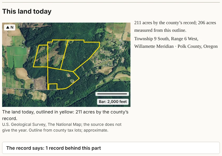
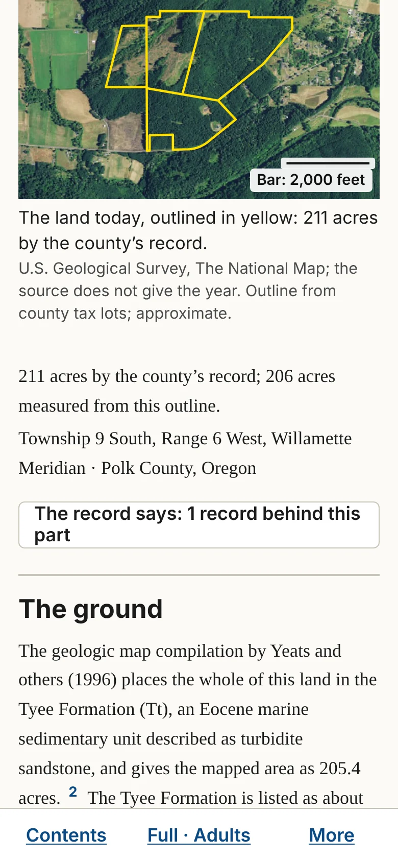
The first part, "This land today," is the land as it is now: the outline on an air photo, with a north arrow and a scale bar; the acres, both the county's figure and the figure measured from the outline; the township and range; and the county. When the records give it, the range of elevation is shown too. A fact the site could not find is simply left out.
The caption reads "The land today, outlined in yellow: [number] acres," with the photo's source and year, or "the source does not give the year," and the word "approximate," because outlines are drawn from map layers, not from a survey on the ground.
In the sample report
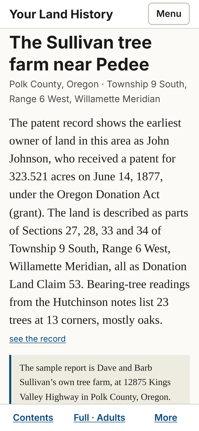
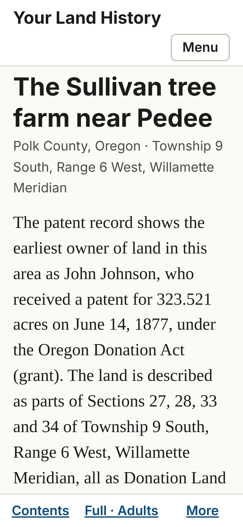
The sample's opening names John Johnson, who received a patent for 323.521 acres on June 14, 1877, under the Oregon Donation Act, for Donation Land Claim 53, in parts of Sections 27, 28, 33 and 34. It adds that the surveyors' notes list 23 trees at 13 corners, mostly oaks. Under the opening, a short note explains why this farm is the sample. "This land today" reads "211 acres by the county's record; 206 acres measured from this outline."1
Notes
- The sample report, October 10, 2026: the opening, from Bureau of Land Management, General Land Office Records, patent to John Johnson, June 14, 1877, 323.521 acres; "This land today," from Polk County tax lots. ↩
Chapter 6. The record behind every sentence
Part 2. Reading your report.
Nothing in a report is said without a record behind it, and every record is one touch away. Sentences that rest on a record end in a small raised number.
Opening a record
Touch a raised number, or see the record after the opening, and the record panel opens directly beneath the paragraph (on a very wide screen, beside the text). The numbers are small, but the area that answers a touch is larger than it looks.
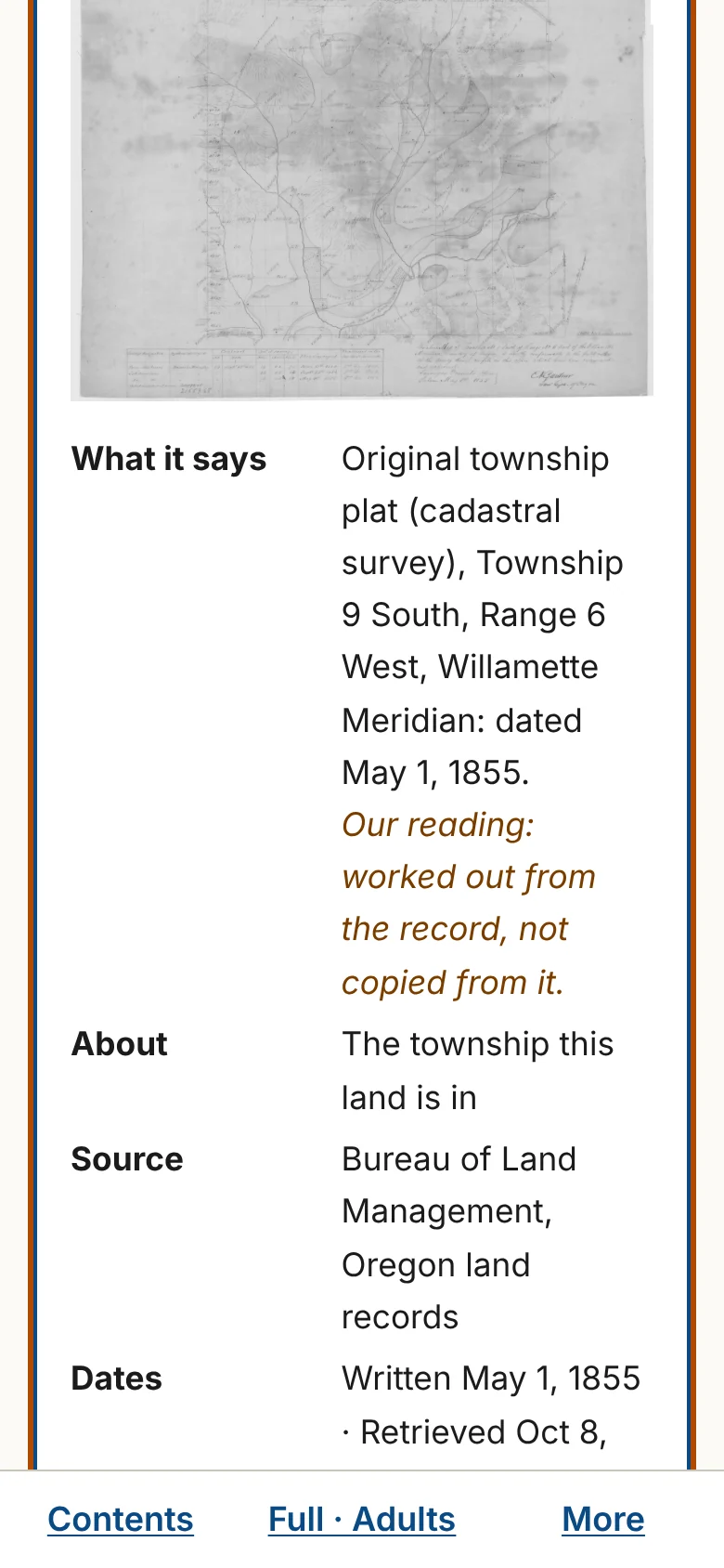
The panel is headed "The record says." It holds a picture of the record when the site has one, and then:
- What it says: the record's own words in quotation marks, or the site's plain wording of it. One of two notes may follow: "Typed from the handwriting by machine. Not yet checked by a person." when a machine typed it from handwriting, or "Our reading: worked out from the record, not copied from it.";
- Our reading: when the record's own words are quoted, the site's plain wording of them;
- About: what the record is about, such as "This land," "This section," "Beside this land" or "The township this land is in";
- Source: the agency or collection, and the record's own number, such as a field-note book and page;
- Dates: when the work was done, approved or indexed, and when the site retrieved it;
- Note: a caution that goes with this one record, such as "Reading needs checking.";
- Cite as: a full reference;
- buttons: Open at the source, which opens the record on the keeping office's website; Copy citation; That's wrong, for sending a correction (Chapter 26); and Close.
To close the panel, touch Close or press the Escape key. You return to the number you touched.
"The record says" at the end of each part
Each part ends with a closed block that reads "The record says: [number] records behind this part." Touch it to open the list of the part's records, grouped under short plain headings such as "The rock under this land." Records about other land are set apart under their own small headings and indented: "Beside this land," "Elsewhere in the same section" and "Around this valley." A neighbor's land claim can never be read as yours.
Pictures
Every picture has a caption that is always visible. The first line says what to notice; the second, in small type, gives the source. Every map shows your land outlined in yellow with a north arrow, and says "approximate," with its reason, wherever a line was fitted to a hand-drawn map. Touch an old survey map to open it full size.
In the sample report
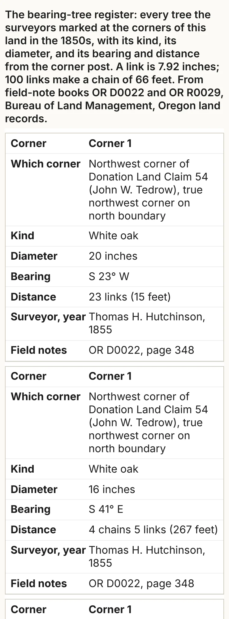
In "The surveyors arrive," the first row of the table of corner trees is a white oak 20 inches across at the northwest corner of the Tedrow land claim, S 23° W of the corner post and 23 links (15 feet) away, from Thomas H. Hutchinson's field notes of 1855, book D0022, page 348. The sentence about that tree ends in a raised number. Its panel names the same source, and because a machine typed the tree from handwriting, it says so: "Typed from the handwriting by machine. Not yet checked by a person."1
Notes
- Thomas H. Hutchinson, field notes of the land claim surveys, Township 9 South, Range 6 West, 1855, BLM Oregon land records, book D0022, page 348; as given in the sample report's table of corner trees. ↩
Chapter 7. The ground
Part 2. Reading your report.
"The ground" tells what the land is made of: the rock underneath, and the soil on top. The rock decides the soil, and the soil decides what grows and what can be built.
What it says. The rock under the land, its age in plain words, and the soils with their farming ratings; at Deep, every unit on the maps.
Where the facts come from. The Oregon Department of Geology and Mineral Industries' statewide geologic map compilation, the U.S. Geological Survey's state-scale geologic map, and the soil survey of the U.S. Department of Agriculture's Natural Resources Conservation Service.
What to notice. A map unit has a name, such as "Peavine silty clay loam, 3 to 30 percent slopes," and a short code, such as "55D." The soil survey rates each soil for farming: prime farmland, farmland of statewide importance, or not prime. The geologic map and the soil map were made separately and at different scales, so their lines do not match exactly.
If the part is folded. "The county's geologic and soil maps cover this land; the details are in the appendix."
In the sample report
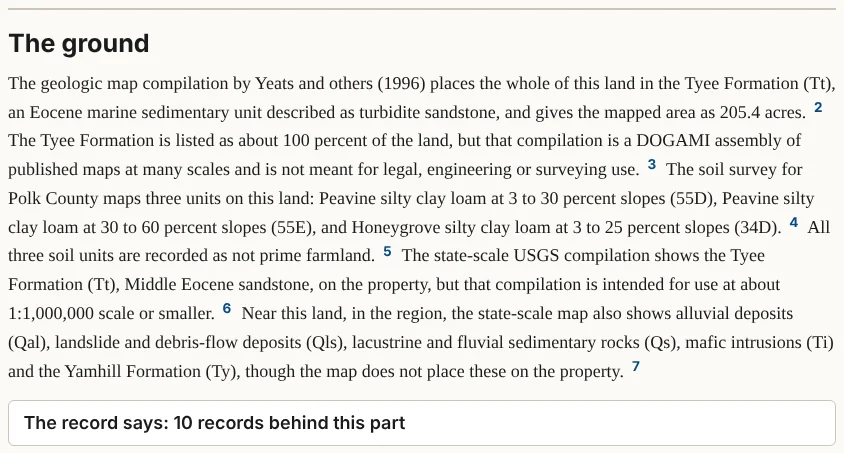
The geologic map places the whole farm on the Tyee Formation, sandstone laid down under the sea in the Eocene epoch. The soil survey maps three soils on it, two Peavine silty clay loams and a Honeygrove silty clay loam, and rates none of them as prime farmland.1
Notes
- Oregon Geologic Data Compilation, release 6 (DOGAMI); NRCS soil survey, Polk County; as given in the sample report, retrieved October 2026. ↩
Chapter 8. Water and weather
Part 2. Reading your report.
"Water and weather" opens by saying where its numbers come from, usually a county-wide average, and then gives how much rain and snow falls in a year, in the earliest records and now.
What it says. Rain, snow and temperature; streams, springs, wells and floods when the records have them.
Where the facts come from. The National Oceanic and Atmospheric Administration's county records, which go back to 1895, and the U.S. Geological Survey for streams.
What to notice. The weather figures are averages for the whole county, not readings taken on your land. Hills and valleys in the same county can differ by many inches of rain.
If the part is folded. "The weather records we have are for the whole county," followed by the first of those county figures.
In the sample report
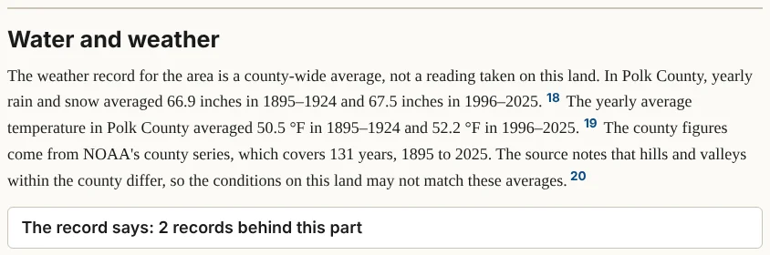
In Polk County, rain and snow averaged 66.9 inches a year from 1895 to 1924 and 67.5 inches from 1996 to 2025, nearly the same. The yearly average temperature rose from 50.5 to 52.2 degrees Fahrenheit over the same two periods.1
Notes
- NOAA National Centers for Environmental Information, Climate at a Glance, Polk County series, retrieved October 8, 2026. ↩
Chapter 9. The people before the surveyors
Part 2. Reading your report.
People lived on every piece of Oregon for thousands of years before a surveyor set a post there. This part names them.
What it says. The people of the valley, the treaty by which the land passed to the United States, and the nations today; at Full, the councils, the removals and the people the records name.
Where the facts come from. The treaties as printed in Charles Kappler's Indian Affairs: Laws and Treaties, the U.S. Forest Service's map of the lands ceded by each treaty, and published histories of the valley.
What to notice. Names are spelled as each document spelled them. The part works at the scale of the valley or the river and never shows a village, a camp or a burial on a map. The tribes exist today and are the authority on their own histories.
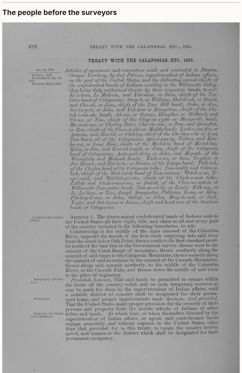
The picture. The first page of the treaty, from Kappler, through the Internet Archive.
If the part is folded. "The treaty that covers this land and the nations today are listed in the appendix." For much of Oregon the records that name individual people have not yet been read for every township (Part 5 says more).
In the sample report
Pedee sits on the Luckiamute River, home of the Luckiamute, one of the Kalapuyan peoples of the Willamette Valley. On May 1, 1851, at Champoeg, three men spoke for them: Daboe, or "Jim"; Scho-la-que, or "John"; and Yuh-kow, as one record spells their names. Federal commissioners asked them to move east of the Cascades. Scho-la-que answered that they "did not wish to leave the country where they had always lived." The Senate never ratified that agreement. The treaty that did take in this land was made at Dayton in January 1855, and the Senate ratified it on March 3, 1855.1
Notes
- Zybach, Soap Creek Valley study (1999), on the council of May 1, 1851; Kappler, Indian Affairs: Laws and Treaties, volume 2, treaty of January 1855 (10 Stat. 1143); as given in the sample report. ↩
Chapter 10. The surveyors arrive
Part 2. Reading your report.
This is often the richest part of a report. Starting in the 1850s, government surveyors walked the section lines with a compass and a chain, and wrote down what they saw: trees, prairies, creeks, fences and houses.
What it says. The date of the first survey map and the surveyors who did the work; the trees they marked at your land's corners; at Deep, every survey map and field-note book for the township.
Where the facts come from. The Bureau of Land Management's Oregon land records: the township plats (the survey maps) and the surveyors' field notes, scanned from the original books.
How to read the old units. The surveyors' chain was 66 feet long, made of 100 links; a link is just under 8 inches, and 80 chains make a mile. The report gives feet beside every chain and link. A bearing such as "S 23° W" means: face south, then turn 23 degrees toward the west. At each corner the surveyor set a post and recorded nearby trees, each with its kind, width, bearing and distance. Those are the bearing trees, also called witness trees: find the tree and you can find the corner. The surveyors' "red fir" is Douglas-fir.
The pictures.
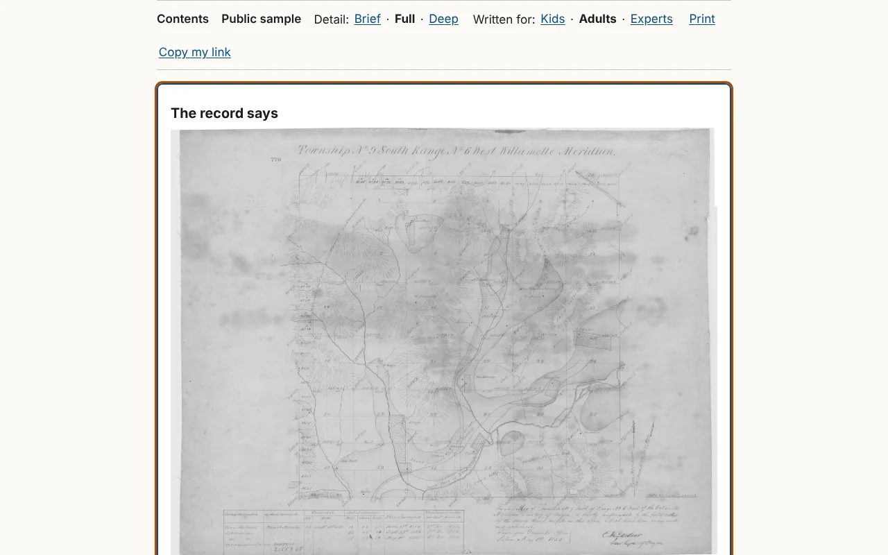
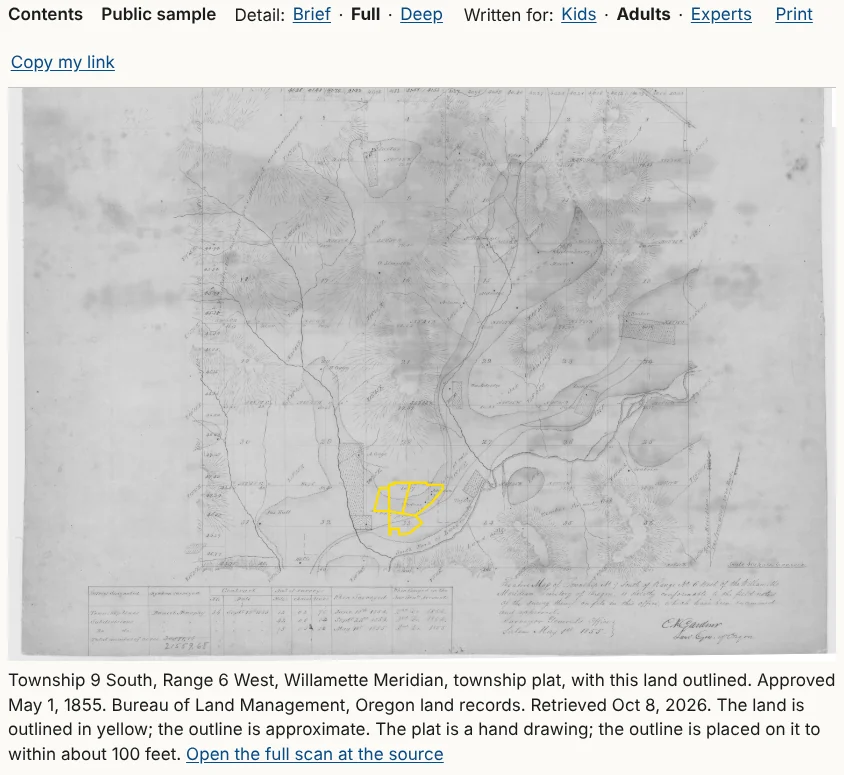
- The township plat, the hand-drawn map made from the notes, with your land outlined and a note on how closely, such as "to within about 100 feet."
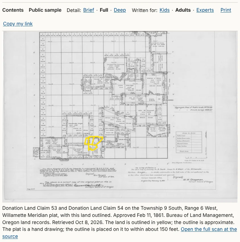
- The claim plat, where the land was a pioneer's claim, showing each claim's owner and number.
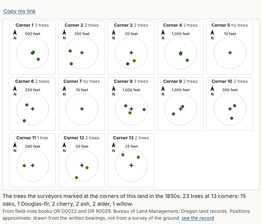
- The corner map, one small panel for each corner, north up, with the post at the center and each tree as a colored dot. Each panel has its own scale, read on its ring.
- The register, a table of every bearing tree: the corner, which corner it is, the kind of tree, its diameter, bearing and distance, the surveyor and year, and the field-note book and page. The entries were typed from the surveyors' handwriting by machine and not yet checked by a person; the appendix's "How sure we are" says so once for the whole report. On a phone each row becomes a card.
In the sample report
The township's first plat is dated May 1, 1855, drawn from Daniel Murphy's notes of 1854. Thomas H. Hutchinson surveyed the two land claims, Donation Land Claims 53 and 54; his notes date the survey of Claim 54, the Tedrow claim, to August 10 and 11, 1855. The corner map's caption tells the farm's oldest story in one line: 23 trees at 13 corners, 15 of them oaks and only one a Douglas-fir.1
Notes
- The sample report, "The surveyors arrive" and its corner map, from BLM Oregon land records: township plat approved May 1, 1855; Daniel Murphy, field notes, 1854, book R0029; Hutchinson (1855), book D0022, pages 347 to 351. ↩
Chapter 11. First owners
Part 2. Reading your report.
Most private land in Oregon left the United States by a paper called a land patent, the government's first deed. Land granted to the state, such as the school sections, passed to its first private owner by a state deed instead. This part names who got your land, when, under which law, and how many acres.
What it says. The patents on your land, with their dates, laws and acres; whether the land lies in a school section; at Full, every patent record found, with those for other land set apart.
Where the facts come from. The Bureau of Land Management's General Land Office Records, the federal database of patents, and the bureau's historical index for the township.
What to notice. The law named in each patent tells how the land left federal hands. In western Oregon the usual ones are the Donation Land Act of 1850, for early settlers; the Homestead Act of 1862; the federal land grants to railroads; and the grants to the state, including the school sections, 16 and 36 in each township. A patent's date is often years after the family settled, because the papers took time. A patent tells you who owned the land then, not who owns it now.
Beside this land. Patents for other land are listed under "Beside this land" or "Elsewhere in the same section," indented; they set the scene but are not about your land. In an area history of a whole section, every patent in that section is about your land and is shown in the main text.
In the sample report
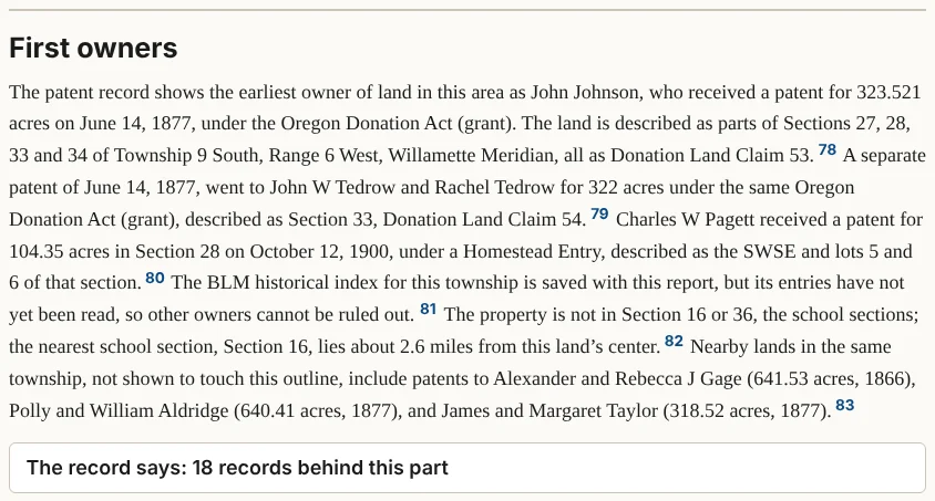
John Johnson and John W. and Rachel Tedrow received their land claims by patents dated June 14, 1877. The Oregon and California Railroad Company received patents in 1897 and 1899. The one homestead patent on the farm is Charles W. Pagett's, for 104.35 acres in Section 28, dated October 12, 1900. The farm is not in a school section; the nearest, Section 16, is about 2.6 miles away.1
From the farm's own history (not in the sample report)
The farm's management plan said the land "was homesteaded around the turn of the century." The records tell it differently. The farm holds only a strip of Pagett's homestead, about 7 acres along its north edge, and most of the rest came from the two 1850s land claims. Knowing Your Land, Chapter 22, tells the whole story.2
Notes
Chapter 12. The families
Part 2. Reading your report.
After the first owners came the people who bought, inherited, farmed and logged the land. This part names the ones the records connect to it.
What it says. Names and years; at Full, census households and passages from county histories.
What to notice. This part is often thin, and that is honest. Family records are mostly kept where a computer cannot fetch them: deed books, census pages behind a free account, old newspapers, cemetery records and family papers. "If you're hooked" says where to look.
If the part is folded. "The census and newspaper records for families here are not part of the basic report."
In the sample report
The sample's families part is one short paragraph. No family or household tied to the township has been found yet, the search for that topic has not been run, and the census figures it gives describe the region, not the farm.1
From the farm's own history (not in the sample report)
The farm's own history went further, by hand. In a 1938 interview, a great-niece remembered John Johnson as "captain of the train," with a place already picked out near Pedee for her grandfather, James Taylor. A pioneer cemetery record adds that on March 19, 1854, Johnson married Taylor's daughter Phebe. Knowing Your Land, Chapter 22, tells how these were found.2
Notes
Chapter 13. Seen from above
Part 2. Reading your report.
Old maps show how the land and its surroundings changed: roads built and abandoned, fields and forest, a town creeping closer.
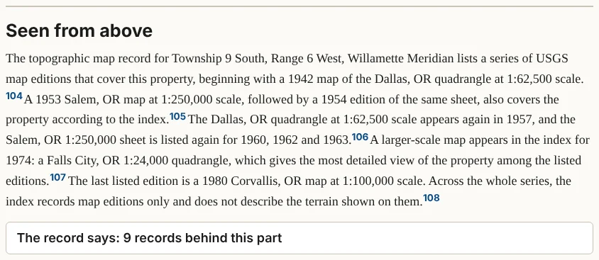
What it says. The editions of the U.S. Geological Survey's topographic maps that cover your land, oldest first, with their scales.
What to notice. A topographic map shows the shape of the land with contour lines. At a scale of 1:62,500 an inch on the map is about a mile on the ground; at 1:24,000 an inch is 2,000 feet. The larger the second number, the less detail.
If the part is folded. "Old maps and air photos of this land are kept elsewhere; "If you're hooked" says where." Many of Oregon's air photos from the 1930s on are held by university libraries, some free to view online.
In the sample report
The oldest map in the sample is the 1942 Dallas sheet, at 1:62,500; the most detailed is the 1974 Falls City sheet, at 1:24,000.1 The sample found no air photos. Its appendix lists old air photos as "Kept elsewhere" and names where they are kept, starting with Oregon Digital, the U.S. Geological Survey's EarthExplorer and the University of Oregon Libraries.
From the farm's own history (not in the sample report)
By hand, the farm's history found air photos of 1936, 1955 and 1978, kept by Oregon State University and free online through Oregon Digital. In 1955 they show open grassland with scattered trees, where today there is Douglas-fir. Knowing Your Land, Chapter 22, follows the change through all three.2
Notes
Chapter 14. Getting here
Part 2. Reading your report.
This part tells where your land sits among named places: the nearest creek, hill and town, and how far each is.
What it says. Nearby named places and their distances; roads, railroads and post offices where the records have them.
Where the facts come from. The U.S. Geological Survey's list of the nation's official place names.
What to notice. The distances are approximate. In the list of named places, a stream or river is marked "near this land," with no distance, because the federal list places each stream at a single point, its mouth, which can be far from where the stream passes your land. Names tell history: a creek named for a family, a "Prairie" where there is now forest. Oregon Geographic Names, at any Oregon library, tells how most names came about.
If the part is folded. "The nearest named places are listed in the appendix."
In the sample report
The nearest named places are Pedee, about 0.6 miles away, and Pedee Creek, about 0.9 miles. The list marks the Luckiamute River only as "a stream named in the national place-names list, near this land."1
Notes
- The sample report, "Getting here," from the USGS Geographic Names Information System. ↩
Chapter 15. Timeline
Part 2. Reading your report.
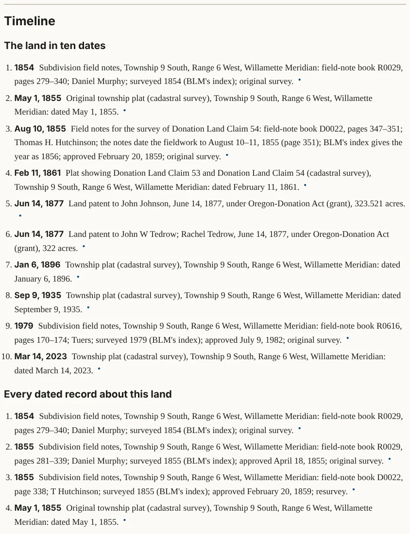
The timeline gathers every dated record in the report in order.
What it says. At the top, under the heading "The land in ten dates," the ten dates that best tell the land's story; at Full, every dated record about your land; at Deep, nearby records too.
What to notice. Look for the gaps. A gap of fifty years between a patent and the next record is not a mistake; it is where the county's deed books, the census and the newspapers come in. A gap in the timeline is a finding.
In the sample report
The sample's ten dates run from Murphy's survey of 1854 and the plat of May 1, 1855, through Hutchinson's claim survey of August 1855 and the claim plat of 1861, to the two patents of June 14, 1877. After that come only later surveys: 1896, 1935, 1979 and 2023.1 Who owned the land after 1877 is a question for the county clerk's deed books, the first step in "If you're hooked."
Notes
- The sample report, "The land in ten dates," from BLM Oregon land records and General Land Office Records. ↩
Chapter 16. If you're hooked: what to do next
Part 2. Reading your report.
The last part of the story is an invitation: three steps chosen for your land, and a fourth that is always the same.
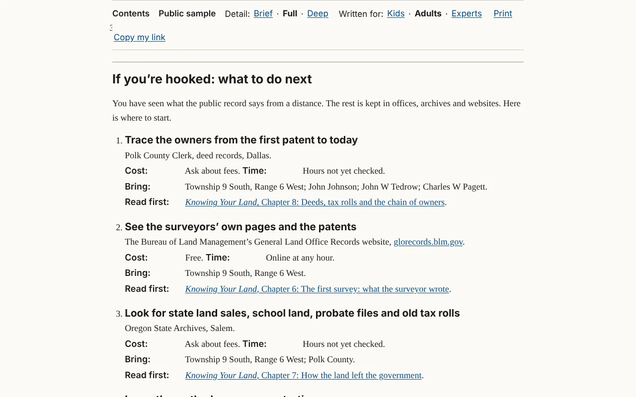
The steps. For most land they are: "Trace the owners from the first patent to today," at the county clerk's deed records in the county seat; "See the surveyors' own pages and the patents," on the Bureau of Land Management's General Land Office Records website; "Look for state land sales, school land, probate files and old tax rolls," at the Oregon State Archives in Salem; and last, "Learn the method, one source at a time," with Knowing Your Land.
What each step tells you. Where to go; "Cost:" and "Time:" (with "Ask about fees" or "Hours not yet checked" where the site has not checked); "Bring:", with your land's township and range and the names of its first owners; and "Read first:", a link to the matching chapter of Knowing Your Land. On your own reports, a step can have an Add to my research list button.
At the foot of the part, a line such as "More places for this land: 19, listed in the appendix, each with "Add to my research list."" leads to every other place the report found where your land's records are kept.
In the sample report
The first step sends you to the Polk County Clerk's deed records, in Dallas. Its "Bring:" line reads "Township 9 South, Range 6 West; John Johnson; John W Tedrow; Charles W Pagett": the names to look up in the deed index.1
Notes
- The sample report, "If you're hooked," October 10, 2026. ↩
Chapter 17. About this report: the appendix
Part 2. Reading your report.
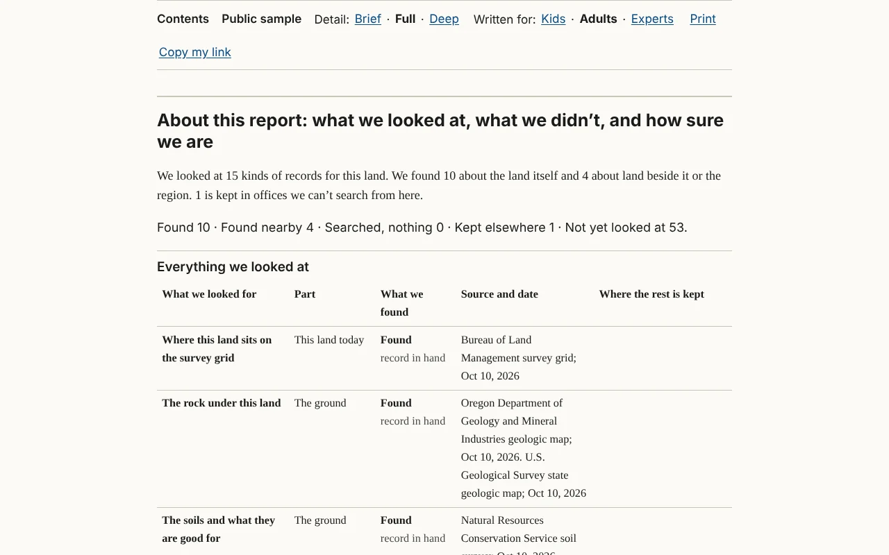
The appendix is the bookkeeping, kept at the back so it never gets in the way of the story. Its heading is "About this report: what we looked at, what we didn't, and how sure we are."
The summary and the counts
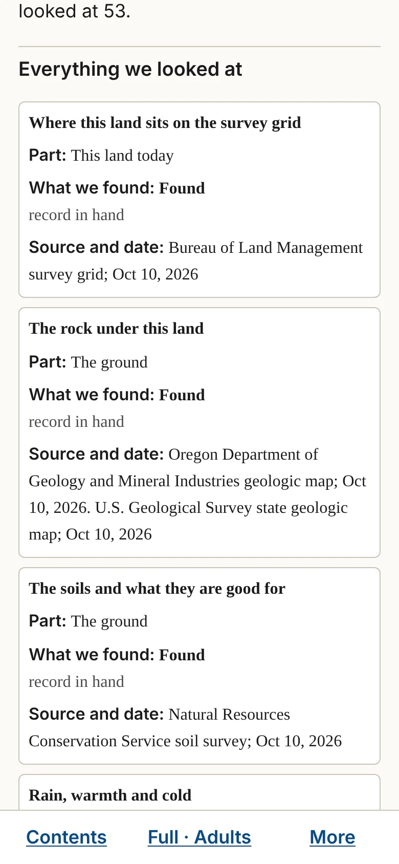
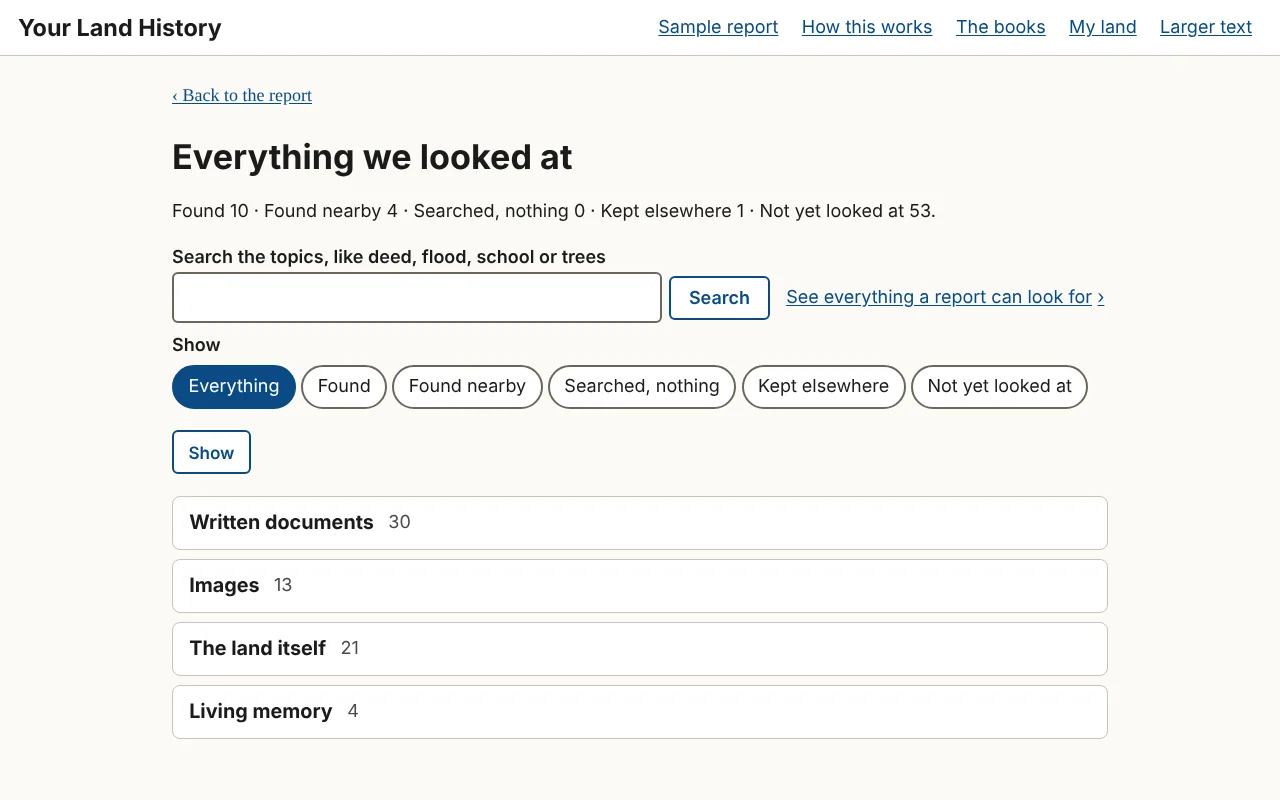
It opens with a few sentences of counts, such as the sample's "We looked at 15 kinds of records for this land. We found 10 about the land itself and 4 about land beside it or the region. 1 is kept in offices we can't search from here." A sentence whose count would be zero is left out. A line of five counts follows, the four status words and "Not yet looked at," such as "Found 10 · Found nearby 4 · Searched, nothing 0 · Kept elsewhere 1 · Not yet looked at 53."
Everything we looked at
A table with one row for each topic the report looked into, and five columns: "What we looked for," "Part," "What we found," "Source and date" and "Where the rest is kept." On a phone each row becomes a card. The "What we found" column uses four words.
| The word | What it means |
|---|---|
| Found | The record is in hand. A smaller label may say more, such as "record in hand." |
| Found nearby | The record is about land beside yours, about an earlier claim that included it, or about the region (labeled "regional"). |
| Searched, nothing | The source was searched and had nothing for this land. |
| Kept elsewhere | The site cannot reach the record from here: it needs a login, a fee or a visit, or the source was down. |
How to read the table. Read across a row: what the report looked for, where it looked, what it found, and where the rest is kept. Then read down the last column. It is your list of errands.
The other blocks
- Where the rest is kept: every place where more of your land's records are kept, each with its office, cost and hours, and on your own reports an Add to my research list button.
- Not yet looked at: the topics outside this report's depth. On your own reports each has Look into this, which starts that one search.
- How sure we are: one plain sentence for each caution the records carry, such as "The outlines on the old maps are placed by hand on the scans, so they are approximate." When two records disagree, this is where the report says so. When the surveyors' handwriting has been typed by machine, the first sentence here says so, once for the whole report.
- Sources, part by part: every source, with the number of records from each and the date retrieved.
The lines at the very end
The appendix ends with the line "Your Land History covers land anywhere in Oregon."; then two lines that end every report. The first says the report is history, not a title search: it does not show who owns the land today or where its legal boundaries lie; for that, ask a title company or a licensed land surveyor. The second says how the report was written. On your own reports it reads: "This report was put together and written automatically, using AI, from the public records it cites. No person has reviewed it." The sample's reads: "Most of this report was written automatically, using AI, from the records cited; the part about the people before the surveyors was written and checked by a person." The back of the report is the place to say these things once. Last come the version line, such as "Version 1, Oct 10, 2026.", whose number goes up each time a search adds to the report, and Forget this land, where it is offered (Chapter 24).
How much shows. At Detail: Brief the blocks are closed. At Full the first ones are open. At Deep all are open.
In the sample report
One caution in the sample's "How sure we are" is a disagreement between two federal records: the field notes date one survey to August 10 and 11, 1855, and the government's index says 1856. The timeline lists that survey under 1855, by the notes, and gives the index's year beside it.1
Notes
- The sample report, "How sure we are"; Hutchinson (1855), book D0022, page 351; BLM Oregon land records, survey index for the township, which gives 1856. ↩
Chapter 18. Detail and Written for
Part 3. Doing more. A report has two kinds of controls. Two of them change how the report reads, instantly, without searching for anything: Detail and Written for. One, Look deeper into this, sends the site out to search again. The rest help you keep, print, share and follow up on what you found.
The first time you open a report, one line under the controls explains both: "Detail changes how much is shown. It never starts a new search. Written for: same facts, different words (Kids: to read with a child; Adults: plain English; Experts: full citations and the surveyors' own terms)."
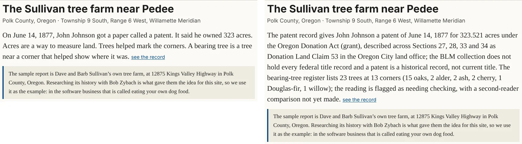
Detail: Brief · Full · Deep
Detail changes how much of what the site has already found is shown. It is instant, never starts a search, and never changes the records.
- Brief shows the opening, "This land today," and each part's short telling. The appendix's blocks are closed. Use it for a quick read or a short printout.
- Full is where every report starts. It shows every paragraph, picture and table. The "The record says" blocks are closed.
- Deep shows everything in Full, with every "The record says" block open and the whole appendix open. Use it to see every record at once.
Written for: Kids · Adults · Experts
Written for changes the wording, not the facts. Kids is for reading with a child. Adults, where every report starts, is plain English. Experts adds full citations and the surveyors' own terms.
The site remembers both choices for each report in your browser, and Print uses them. On a phone, both sit behind the middle button of the bar at the bottom of the screen, which shows your current choices, such as "Full · Adults."
Chapter 19. Look deeper into this
Part 3. Doing more.
Look deeper into this sits at the end of each part of your own reports. It is the only thing on a report that starts a new search. (The sample is the same for everyone, so it has none.)
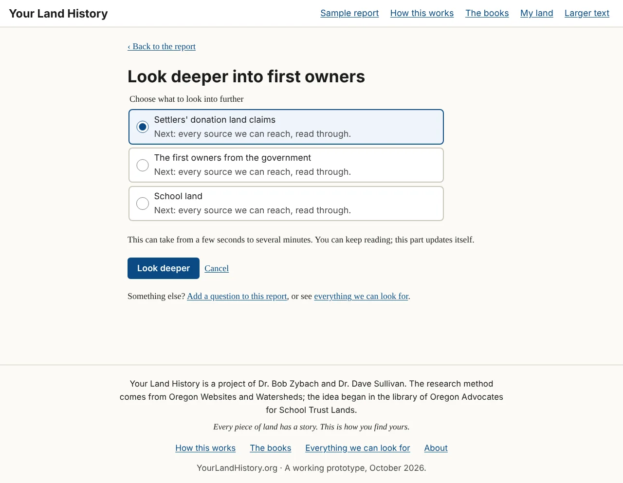
If a part rests on only one topic, the button starts that search at once. Otherwise a short page opens, headed with the part's name, such as "Look deeper into first owners," with the line "Choose what to look into further." It lists the part's topics, each with a line beginning "Next:" that says what a deeper search adds, such as "Next: every source we can reach, read through." That line describes the search, never what it will find. Choose one and touch Look deeper, or Cancel. The page says: "This can take from a few seconds to several minutes. You can keep reading; this part updates itself."
At its foot is a line for anything else: "Something else? Add a question to this report, or see everything we can look for."
When the search starts, a line at the top of the report says what is being looked into. The old text stays readable until the new text replaces it, and the report's version number goes up by one. A search that finds nothing is not wasted: the appendix records that the source was searched, and when.
Chapter 20. Everything we can look for
Part 3. Doing more.
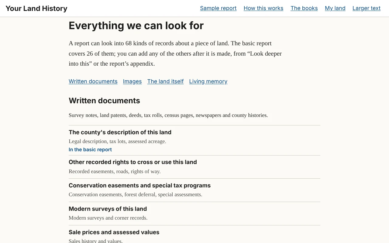
Before you can ask for more, you need to know what there is to ask for. Everything we can look for is the full menu. Its first line: "A report can look into 68 kinds of records about a piece of land. The basic report covers 26 of them; you can add any of the others after it is made, from "Look deeper into this" or the report's appendix."
Open it from Everything we can look for at the foot of every page; from See everything a report can look for ›, under the four lines on the front page and beside the search box on "Everything we looked at"; or from the Look deeper page of any report. Scroll through it like a table of contents. Topics in the basic report are marked "In the basic report."
The topics are grouped by the four kinds of evidence that Knowing Your Land is built on, with a link to each group at the top. Each topic is named in a few plain words and has a one-line note on what it tells you.
- Written documents: the surveyors' field notes, land patents, deeds and tax records, census pages, newspapers, and the names of places.
- Images: the survey maps called plats, topographic maps, old air photos and satellite images.
- The land itself: rock, soil and the shape of the land, water and weather, what grows there, and fire.
- Living memory: what people who know the place remember, and the papers and photographs families keep. Only a person can gather these, so the site lists where to start.
Everything we looked at
Everything we can look for is the menu for any land. Everything we looked at, reached from the appendix, is the record for one report: the appendix's table on a page of its own, with a search box ("Search the topics, like deed, flood, school or trees") and filters: Everything, Found, Found nearby, Searched, nothing, Kept elsewhere and Not yet looked at. Its rows are grouped by the same four kinds of evidence. On your own reports, a row not yet looked at has Look into this, and a row already searched has Look deeper into this.
Chapter 21. My research list
Part 3. Doing more.
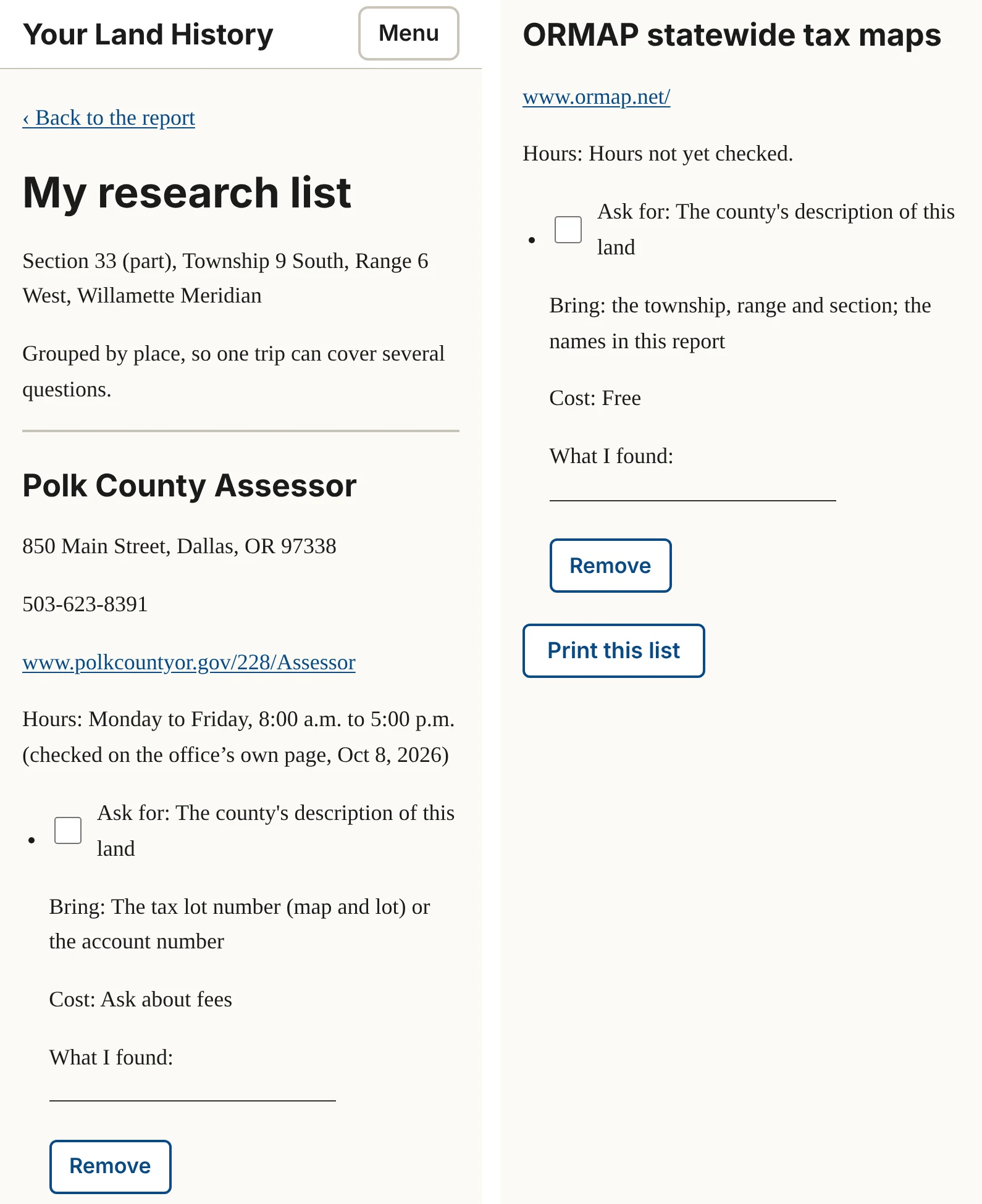
Much of a land's history is kept in offices: deed books at the county, estate files at the state archives, old photographs at a historical society. My research list turns those into errands, grouped by place, so that one trip covers several questions. Its top line says so: "Grouped by place, so one trip can cover several questions."
Filling it
A new list is empty, and says how to fill it: "Use "Add to my research list" in "If you're hooked" or in the report's appendix." Those buttons appear on your own reports, beside the steps in "If you're hooked" and beside each place in the appendix's "Where the rest is kept." Once the list has something on it, My research list, with its count, appears in the row of controls. It is always in the menu This report.
What is on it
Each place has its name; its street address, telephone and website, where it has them; and its hours, "checked on the office's own page" with a date, or "Hours not yet checked" (then call ahead). Each errand under it has a box to tick, "Ask for:", "Bring:", "Cost:" ("Free" or "Ask about fees"), a line headed "What I found:", and Remove.
Taking it on a trip
Touch Print this list. It prints with boxes to tick and lines to write on. Once loaded, the page stays readable on your phone even with no signal, which helps in a courthouse basement.
In the sample report
The sample's menu offers My research list, but the list stays empty, because the sample has no Add to my research list buttons. Its first step in "If you're hooked" names where the first errand would be: the Polk County Clerk's deed records, in Dallas.
From the farm's own history (not in the sample report)
The farm's own history found a head start for that errand: the 1993 survey of the farm cites an earlier county survey and three easements by book and page, which tell the clerk exactly where to begin. Knowing Your Land, Chapter 22, tells the rest.1
Notes
- Partition Plat No. 1993-0029, June 24, 1993, Polk County survey CS 12769, as described in A History of the Land: The Story of the Sullivan Tree Farm near Pedee, Polk County, Oregon (October 2026), "Next steps for this property." ↩
Chapter 22. Printing a report and saving it as a PDF
Part 3. Doing more.
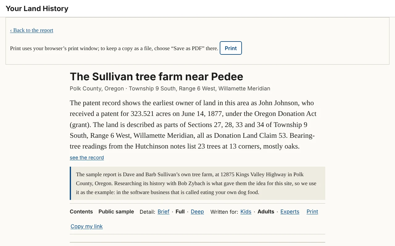
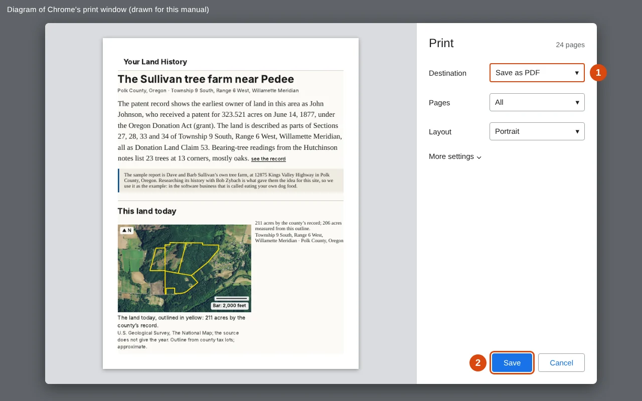
Touch Print in the row of controls. A print page opens with the report laid out for paper: no buttons, every picture with its caption, your Detail and Written for choices, and the appendix at the end. At its top is the line "Print uses your browser's print window; to keep a copy as a file, choose "Save as PDF" there," with a Print button. Touch it to open your browser's print window. Choose Brief before printing for a short printout, Deep for every record.
Saving a PDF file
A PDF is a file that looks exactly like the printed pages. The site does not make the file itself; your browser does, from its print window.
Chrome, on a Windows computer or a Mac. In the print window, find "Destination," choose "Save as PDF," then click "Save" and choose where to keep the file.
Edge, on a Windows computer. Under "Printer," choose "Save as PDF," then click "Save" and choose where to keep the file.
Safari, on a Mac. At the bottom of the print window, open the small menu marked "PDF" and choose "Save as PDF." Give the file a name and click "Save."
iPhone or iPad. The "Print Options" screen appears. Touch the share button at the top of the screen (a square with an arrow pointing up). If you do not see one, spread two fingers apart on the page preview to open it full size, then touch the share button. Choose "Save to Files," pick a place, and touch "Save."
Android phone. At the top of the print screen, touch the printer's name and choose "Save as PDF." Touch the round PDF button, choose a folder, and touch "Save."
Most print windows also have a setting called "Headers and footers," which adds the date and the page's web address to each sheet. Turn it off for clean pages, or leave it on to keep the report's link on paper.
Chapter 23. Copy my link
Part 3. Doing more.
Every report has its own web address, and that address is the key to it. There are no accounts and no passwords. Anyone who has the link can open the report, and nobody else can.
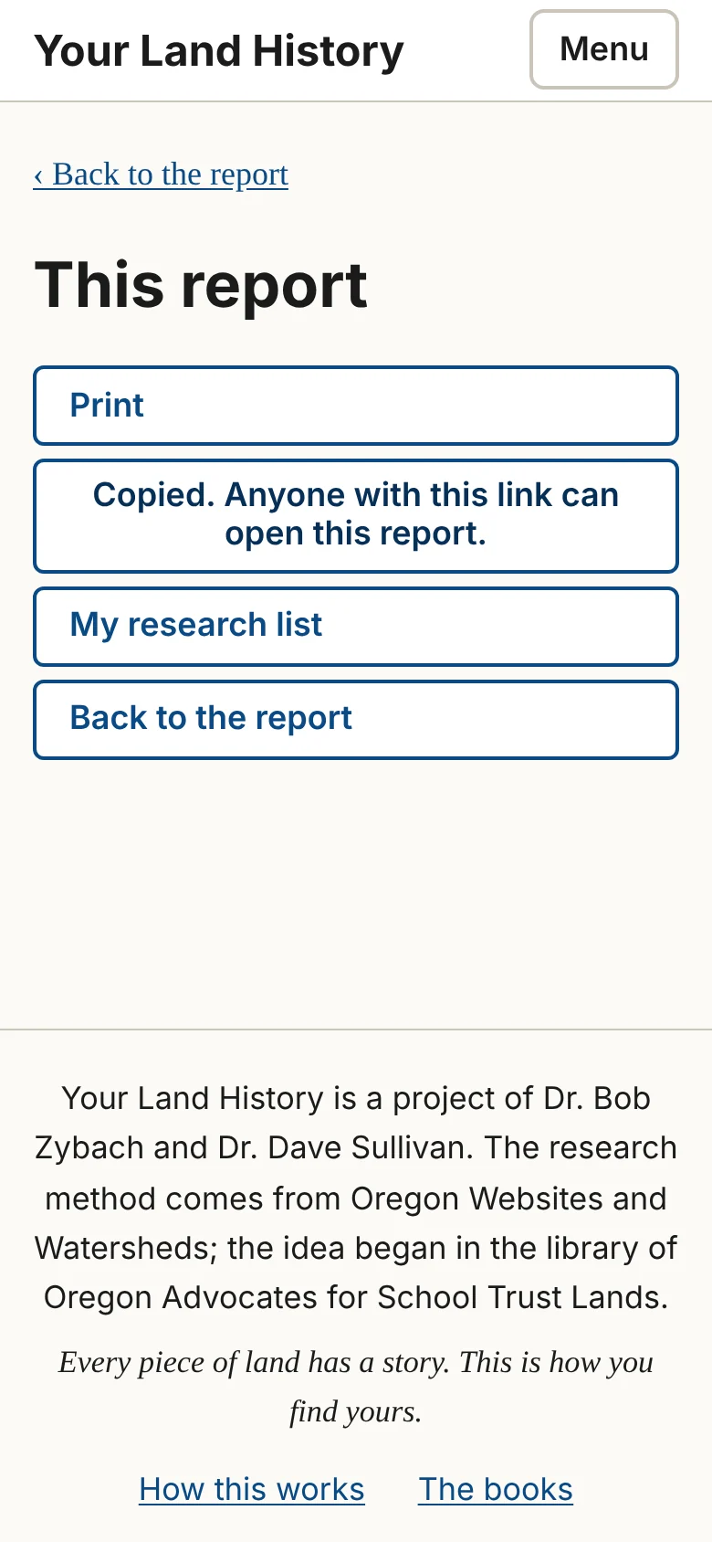
Copy my link, in the row of controls and in the menu This report, copies the address, and the site answers "Copied. Anyone with this link can open this report." Paste it into an email to yourself, a text message or a note, so you can open the report from any phone or computer. To share a report, give the link to the people you want to see it, and to no one else. If the button does not copy on your device, copy the address from the bar at the top of the browser instead.
The sample report's link is public, with its owner's consent, and you are welcome to pass it on.
Chapter 24. My land, Forget this land and Larger text
Part 3. Doing more.
My land
My land, in the header, lists the reports made in this browser, newest first, with the line "Reports you make in this browser are listed here. To open one on another device, use its link." If you clear your browser's data, or switch browsers or devices, the list starts empty, but your reports still exist at their links.
This report
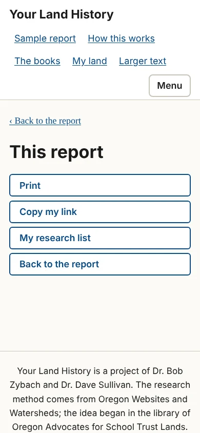
On a phone, More in the bottom bar opens a short menu called This report: Print, Copy my link, My research list, Forget this land (on your own reports), and Back to the report.
Forget this land
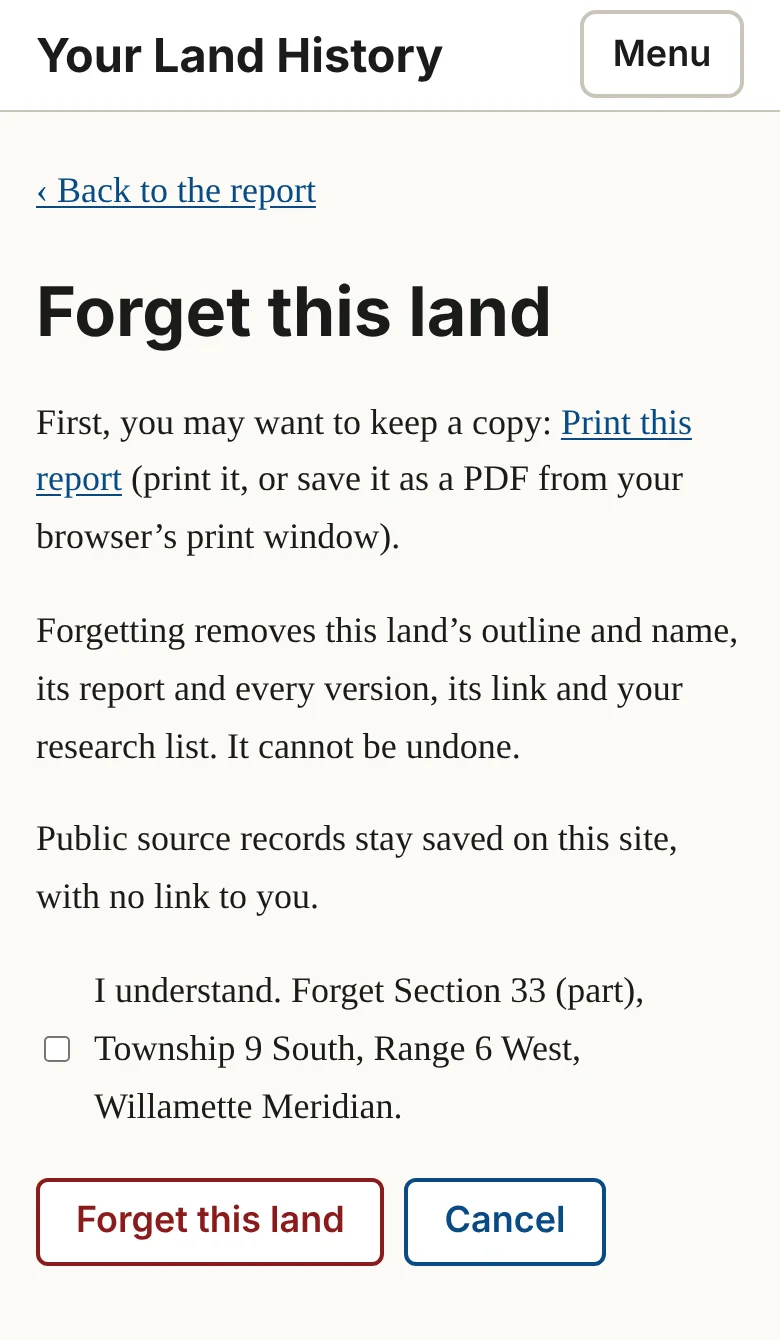
Forget this land removes a report for good. It is offered on your own reports, at the end of the appendix and in This report, never on the sample. The page begins: "First, you may want to keep a copy: Print this report (print it, or save it as a PDF from your browser's print window)." Then it explains: "Forgetting removes this land's outline and name, its report and every version, its link and your research list. It cannot be undone." The public source records stay saved on the site, with no link to you.
To go ahead, tick "I understand. Forget [name of the land]." and touch Forget this land, or touch Cancel. The page says the link goes too, so print or save first anything that you, or anyone you gave the link to, will want to keep.
Larger text
Larger text, in the header, makes the words bigger on every page. On a phone, touch Menu, then Larger text. It then reads Normal text; touch it to go back. For larger still, use your browser's zoom: hold Ctrl (Windows) or Command (Mac) and press the plus key, or on a phone spread two fingers apart on the page.
Chapter 25. What you see and what to do
Part 4. When something goes wrong. Most problems have a one-touch answer, and none loses your work. What you typed is never cleared, and a report's link always brings back whatever has been gathered so far.
Messages beside the boxes on the front page
These appear next to the box they belong to, beginning "To fix:". Here is every one, word for word, with what to do.
| The message | What to do |
|---|---|
| "Township needs a number, like 9." | Type the number only, without "South" or "North." |
| "Choose North or South for the township." | Touch North or South. Most Oregon land is South. Only the northern strip of the state, north of a line through Portland, is North. |
| "Range needs a number, like 6." | Type the range number. |
| "Choose East or West for the range." | Touch East or West. Land west of the Willamette Meridian, which runs through Portland, is West. |
| "Section needs a number from 1 to 36, like 33." | If your deed names no section, use the claim or lot box, or your tax lot. |
| "Township [number] [North or South], Range [number] [East or West] has no Section [number]. Check the section number on your deed." | Some townships along the coast, the Columbia and the state lines lack some sections. Check each number; a slip between North and South, or East and West, is the usual cause. |
| "We found Section [number] but not "[part]". You can go on with the whole section, or check the part on your deed." | Touch Go on with the whole section, which includes your land, or fix the drop-down lists. |
| "We could not find claim [number] in Township [number] [North or South], Range [number] [East or West]. Check the number on your deed." | Check the claim or lot number on your deed, or empty that box to use the whole section. |
| "We could not find a township and range in what you pasted. Type them into the boxes above. Your pasted words are still here." | Find "Township" and "Range" (or "T." and "R.") in your words and type the numbers in. |
| "Choose your county." | Pick your county from the list. |
| "Map number is missing. Copy it from your statement, like 9S 6W 33." | Type the map number as your statement prints it. |
| "Add the direction letters: N or S after the township, E or W after the range, like 9S 6W." | Add the letters, as in "9S 6W 33." |
| "Tax lot needs a number, like 01400. Keep the zeros." | Type the tax lot with its leading zeros. |
| "We could not find tax lot [number] on [county] County map [map]. Check both numbers on your statement." | Check the map number, with its letters, and the tax lot, with its zeros. Or type the township, range and section from the map number into Legal description. |
| "Account number is numbers only, like 123456." | Remove any letters or dashes. |
| "Give the map number and tax lot, or the account number." | Fill in the map number and the tax lot. The account number is not used yet. |
| "We can't look up land by account number yet. Use the map number and tax lot printed on the same statement, or your legal description." | Type the map number and the tax lot from the same statement, or use Legal description. |
| "Type a house number and street, like 123 Main Street, Monmouth, Oregon." | Type the address with its house number. |
| "We couldn't find that address. Country roads are often missing from the federal address list we use. Try your tax lot or legal description; both are on your property tax statement." | Use Tax lot or Legal description. |
| "That search did not answer just now. Please try again in a minute. What you typed is still here." | Wait a minute and touch Find my land again. |
Everything else
| What you see | What to do |
|---|---|
| "We can't search [county] County's tax lots yet..." | Touch Use the legal description. You will get an area history of the section, which includes your lot. |
| "We can't make a report in Township [number] [North or South], Range [number] [East or West] yet..." | Nothing you did is wrong. Try again later. Meanwhile, Chapters 6 and 7 of Knowing Your Land show how to find your township's survey notes and patents yourself, free. |
| The outline on "Is this your land?" is in the wrong place. | Touch No, that's not it. Check North or South and East or West first, then the section number. |
| The outline covers a whole square mile, not your own lot. | Go back and choose the part of the section from your deed, or use your tax lot. Or say yes to the area history, which includes your land. |
| The place line on "Is this your land?" says Washington. | Touch No, that's not it, then check the township number and North or South. Your Land History covers Oregon only. |
| A part says "Not finished," or "We stopped this part before it was finished. What we found is kept." | Touch Try again. If it stops again, come back later. Nothing found so far is lost. |
| "One source did not answer today: [source]. The rest of this part is here." | That source's website was down or slow. Touch Try again, today or another day. |
| The page seems stuck. Nothing has changed for ten minutes. | Reload the page. If parts are still waiting, come back in an hour through My land or the report's link. |
| Open at the source does not open, or opens the wrong page. | The office's website may be down or may have moved the record. Try later, or touch Copy citation and search the office's site for the record's name and number. |
| The site is slow. | Pictures arrive as you scroll toward them. Choose Detail: Brief for a lighter page. |
| The sample report has no Look deeper into this, Add to my research list or Forget this land. | The sample is the same for everyone, so it cannot be searched further, listed or forgotten. Make a report of your own land to use those buttons. |
| "We can't send corrections yet. Your sentence is still in the box above, so nothing is lost." | Copy your sentence and email it to drdavesullivan@gmail.com, or try again later (Chapter 26). |
| Copy my link does not say "Copied." | Copy the address from the bar at the top of your browser instead. |
| The words are too small. | Touch Larger text in the header (on a phone, under Menu), or use your browser's zoom (Chapter 24). |
| My research list on the sample is empty and points to buttons the sample does not have. | The sample cannot be added to. Make a report of your own land; its "If you're hooked" and its appendix have Add to my research list. |
| A report is missing from My land. | You may be in a different browser or device, or the browser's data was cleared. Open the report from its link. |
| The printout has pictures missing. | Pictures load as you scroll. On the print page, scroll to the end before touching its Print button. |
| A sentence in a report seems wrong. | See Chapter 26. |
Chapter 26. Telling us about a mistake
Part 4. When something goes wrong.
The records are old, the handwriting is hard, and machines that read it make mistakes. If you know a sentence is wrong, the project wants to hear it.
From the record panel. Every record panel has a button, That's wrong. It opens a page that shows the sentence and asks "In one sentence, what is wrong?" Type your answer and touch Send it for review. The site answers "Thank you. Your correction is waiting for a person to review it." A correction changes nothing until a person has checked it. If corrections cannot be sent yet, the site says so and keeps your sentence in the box.
By email. Send corrections, additions and questions to drdavesullivan@gmail.com. The same address is on the About page, "Who is behind Your Land History." Email suits anything longer than one sentence, and anything the report does not mention at all.
What to say. What is wrong, and how you know: a deed, a family paper, a gravestone, a visit to the land. The page already shows the sentence you are correcting.
Notes on this manual. If this manual was unclear somewhere, write to drdavesullivan@gmail.com and say where.
Chapter 27. Short answers
Part 5. Questions people ask.
Your report is private
Only people who have its link can open it, and it never shows the street address you typed. The one public report is the sample, with its owner's consent; it is the same page for everyone, which is why it cannot be searched further or forgotten.
The site is free
There is no account, no payment and no email address to give. Offices and archives that you visit later may charge for their own copies.
No account is needed
Your report's link is your way back to it. Keep the link somewhere safe (Chapter 23).
Land you don't own
The records are public, so any Oregon land can be looked up: a grandparent's farm, a schoolyard, a park. The report stays private to whoever made it.
Land outside Oregon
Version 1.1 covers land anywhere in Oregon, and only Oregon. Washington is surveyed on the same grid, but the site does not yet gather Washington's records. Other states may follow.
Tax lots outside Polk County
In this version the site can search tax lots only in Polk County, whose lot lines it has loaded. For other counties it reads the township, range and section out of your map number and offers to go on with those (Chapter 1). You get a history of the whole section, which includes your lot.
Records marked "Found nearby"
The record is real but is not about your land itself. It is about an earlier claim that included your land, about land beside yours, or about the region. The report sets such records apart so a neighbor's patent can never be read as yours (Chapter 17).
When "The people before the surveyors" names no one
The records that name individual people, such as treaty councils and published studies, mostly cover whole valleys and have not yet been read for every township. For much of Oregon the report can name the bands, the treaty and the nations today, but not yet the people. Chapter 16 of Knowing Your Land shows where to look, and the tribes are the authority on their own history.
Bearing trees
A bearing tree is a tree that a government surveyor marked and wrote down beside a corner post, so that the corner could be found again. The surveyor recorded its kind, its width, its compass bearing from the post and its distance. On the sample farm, 15 of the 23 recorded trees were oaks.
A report is not a survey
The outlines are pictures drawn from map layers, and they are approximate, so a report cannot settle a boundary dispute. It tells the land's history. For where a boundary runs, ask a licensed land surveyor; for who owns the land, ask a title company.
Today's owner is not in the report
Who owns the land now is a question of title, which the site does not search. The county clerk's deed records carry the chain of owners from the first patent to today, and "If you're hooked" says how to start.
The two acre figures
One is the county's figure, the one on your tax statement. The other is measured from the outline on the map. They are made in different ways for different jobs, so they seldom match.
A computer program writes each report
Each part is written by a computer program from the public records it cites. No person reviews your report before you read it. The sample is the one exception, in part: its "The people before the surveyors" was written and checked by a person, and its last lines say so. Every sentence points to its record, so you can check any of them yourself.
The note "Reading needs checking"
Some records, such as the surveyors' notebooks, exist only as handwriting. A machine read the handwriting and typed it, and no person has yet checked that typing against the page. The record panel says "Typed from the handwriting by machine. Not yet checked by a person." and adds the note "Reading needs checking." The appendix's "How sure we are" says the same once for the whole report. Open at the source shows the page itself, so you can judge for yourself.
Using the pictures
Most of the pictures can be used. The source line under each picture names where it came from. Records made by federal agencies, such as the Bureau of Land Management's plats and field notes and the U.S. Geological Survey's maps, are generally free for anyone to use. For others, ask the source the line names. Whenever you use a picture, give its source line with it.
Citing a report or a record
For a record, touch its raised number, then Copy citation, and paste. For the whole report, give its name, "Your Land History," the date of its version (the last line of the appendix), and its link if readers should be able to open it.
Publishing a report or adding your own papers
Neither is possible in this version. You can give the link to anyone you choose, and you can print the report.
How current a report is
Each record shows the date the site retrieved it, and the version line at the end of the appendix shows when the report last changed. Look deeper into this searches again.
At the back: words, further reading and about this manual
The words used
Words you will meet in reports and county offices. Knowing Your Land explains each at greater length.
Account number. The county assessor's number for a property's tax account. The site cannot look land up by it yet.
Air photo. A photograph taken looking straight down from an airplane. Oregon's begin in the 1930s.
Area history. A report on a whole section, or the land around a point, made when the site cannot outline your lot.
Bearing. A compass direction written from north or south toward east or west. "S 23° W" means face south, then turn 23 degrees toward the west.
Bearing tree. A tree the surveyor marked beside a corner post and recorded, so the corner could be found again. Also called a witness tree.
Chain. The surveyor's measuring chain, 66 feet long, made of 100 links. Eighty chains make a mile.
Claim plat. A survey map that shows the donation land claims in a township, each with its owner's name and number.
Donation land claim. Land given to early settlers of Oregon under the Donation Land Act of 1850. Claims could be started until 1855.
Field notes. The notebooks that government surveyors kept as they walked the lines.
General Land Office. The federal office that surveyed public land and issued patents from 1812 to 1946; its records are now the Bureau of Land Management's.
Homestead. Land granted under the Homestead Act of 1862 to a settler who lived on it and worked it for five years.
Land patent. The paper by which the United States passed land to its first private owner.
Legal description. The words in a deed that say exactly which land is meant.
Link. One hundredth of a chain, just under 8 inches.
Map number. The number of the county tax map a tax lot is on. It is built from the township, range and section.
Plat. A survey map. A township plat shows a whole township; a claim plat shows its land claims.
Quarter section. A quarter of a section, 160 acres. A quarter of a quarter is 40 acres.
Range. A column of townships, counted east or west from the Willamette Meridian.
Raised number. The small number after a sentence. Touch it to see the record behind the sentence.
Research list. The errands for your land, grouped by the place where each record is kept.
School sections. Sections 16 and 36 of each township, granted to Oregon for its schools.
Section. A square of land about a mile on a side, 640 acres. A township holds 36.
Tax lot. The unit by which the county taxes land. It is not a legal description, and its lines are not survey lines.
Topographic map. A map that shows the shape of the land with contour lines.
Township. A square of land six miles on a side, counted north or south from the base line.
Treaty. An agreement between the United States and Native nations. Treaties of the 1850s ceded much of western Oregon to the United States.
Willamette Meridian. The north-south line, starting at the Willamette Stone in Portland's West Hills, from which every township and range in Oregon and Washington is counted.
Where to read more in Knowing Your Land
Each part of a report rests on a family of records. Knowing Your Land, by Bob Zybach, gives each family a chapter: what it tells you, where to find it, how to read it and what it costs. Use this table to go from the part you are reading to the chapter that explains it. On the site, "Read first:" links in "If you're hooked" do the same.
| Part of the report | Chapter of Knowing Your Land |
|---|---|
| This land today | 3. Find your legal description, tax lot and acreage; 15. What grew there: plants, forests, fire and crops |
| The ground | 13. Rock, soil and the shape of the land |
| Water and weather | 14. Rain, rivers and the weather people remember |
| The people before the surveyors | 16. The first people on the land |
| The surveyors arrive | 6. The first survey: what the surveyor wrote; 11. Maps and survey plats; 17. What you can see on the ground |
| First owners | 7. How the land left the government |
| The families | 8. Deeds, tax rolls and the chain of owners; 9. Census pages, newspapers, journals and county histories; 18. What people remember, and what families keep |
| Seen from above | 11. Maps and survey plats; 12. Photographs from the ground, the air and space |
| Getting here | 10. Buildings, cemeteries and place names; 20. Following change through time: roads, railroads and land use |
| Timeline | 19. Putting the pieces together |
| If you're hooked: what to do next | 24. If you're hooked: what to do next; 25. An Oregon directory of offices and websites |
| About this report | 19. Putting the pieces together; 5. How the site Your Land History fits with this guide |
| The sample, from beginning to end | 22. One tree farm from beginning to end |
About this manual
This is the adult edition of Your Land History: The User's Manual, version 1.1, October 2026. It describes the website Your Land History, version 1.1, at YourLandHistory.org. It was made from the site's design document, Your Land History: Website Design, version 1.1 (October 10, 2026), and from the site itself. Where the two differ, the site is right, and the next edition of this manual will follow it. Screens change; the pictures here show the site as it was in October 2026.
The reports on the site are put together and written automatically, using AI, from the public records they cite. The first draft of this manual was written the same way, from the design and the site, and the Your Land History project is responsible for it.
Like every report, this manual is about historical research, not title research. Nothing in it tells you who owns a piece of land today or where its boundaries lie.
A Kids edition and a Professional edition may follow, and this edition will be revised as readers say where it fell short. Send corrections to drdavesullivan@gmail.com, or use That's wrong beside any record on the site.
Prepared by the Your Land History project, a project of Dr. Bob Zybach and Dr. Dave Sullivan, with thanks to Oregon Advocates for School Trust Lands and Oregon Websites and Watersheds.