
Chapter 6. The first survey: what the surveyor wrote
In March 1854 a deputy surveyor named Daniel Murphy set a post halfway down the west side of Section 33, in the hills just west of Pedee. It stood "in dooryard," 39 links (about 26 feet) from "Mrs Gillam's dwelling."1 The government had not yet issued that family a patent, but they were already living on the land, and the government's own surveyor wrote down where their house stood.
Before the United States granted land to anyone, it sent surveyors to measure it. For most land in the western states, their field notes are the earliest written description of the ground. They are free and online, and an evening is enough to learn to read them.
How the survey was run
The survey worked from the outside in. In the tree farm's township, surveyors ran the outer lines of the 6-mile square in 1852 and 1853.2 Then a deputy surveyor divided the township into sections. Murphy ran the lines around what is now the Sullivan tree farm from March 13 to 16, 1854, and Figure 6.1 is one page of his notes.3 At every section corner he set a post, and he set another at each quarter corner, halfway along a section line.4
He measured with a chain, 66 feet long and divided into 100 links, so a link is just under 8 inches (7.92 inches). Eighty chains make a mile, and a section is about 80 chains on a side.4
The settlers' claims came next. In Oregon many families had chosen their land before the surveyors arrived. Each donation land claim, a free grant to an early settler under an act of 1850, got a survey of its own (Chapter 7). In the farm's township that work fell to Thomas H. Hutchinson in the summer of 1855.5 Land in western Oregon may need both sets of notes, for the section lines and for the claim lines.
Texas, Hawaii, and the eastern states from Maine to Georgia, with Kentucky, Tennessee and West Virginia, were never surveyed this way (Chapter 3).6
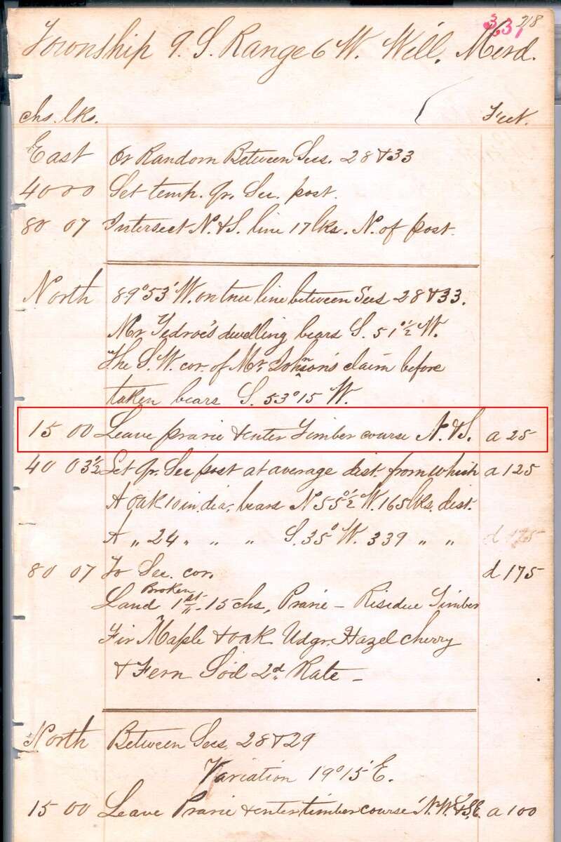
Figure 6.1. A page of Daniel Murphy's field notes, March 1854. The outlined entry, 15 chains along the line between Sections 28 and 33, reads "Leave prairie & enter Timber." Just above it Murphy sights "Mr Tedroe's dwelling"; below it he sets a quarter-section post and sums up the mile. Daniel Murphy, field notes of Township 9 South, Range 6 West, Willamette Meridian, 1854. Bureau of Land Management, Oregon land records, volume R0029, page 331. Public domain. Outline added.
What it tells you
A surveyor's notes follow the line as he walked it. Every few chains he noted what he met: a creek, a trail, a fence, a field, a house, the edge of a prairie or of timber.7 At each corner he described the post and the trees around it, which is how Figure 6.2 could be drawn. At the end of each mile he summed up the land, its soil, its timber and its undergrowth. The printed instructions of 1855 asked for soil to be rated "first, second, or third rate" and for trees to be listed "in the order in which they predominate."8
The page in Figure 6.1 shows that summary for the mile between Sections 28 and 33. Murphy counted 15 chains of prairie on the line and called the "Residue Timber": "Fir Maple & oak," with an undergrowth of "Hazel cherry & Fern." He rated the soil "2d Rate."9
Claim surveys add a closing paragraph about the claim as a whole. On the Tedrow claim, Hutchinson wrote in August 1855 that "the other half is covered with fir & oak timber of good quality" and that "the Luckiamute river runs through the south part." He added that "there is but little improvement on the claim" (Figure 6.3).10
Settlers' houses are the prize. The same instructions told surveyors to take bearings on a dwelling in sight of the line from two points along it.8 Murphy's page reads "Mr Tedroe's dwelling bears S. 51½° W."9 A sighting like that, from a corner that can still be found, lets you work out roughly where a house of 1854 stood.
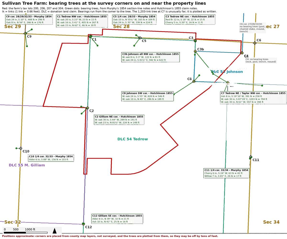
Figure 6.2. The bearing trees of 1854 and 1855 on and near the tree farm. Each dot is one tree the surveyors recorded, plotted from its corner by the bearing and distance in their notes. Count the oaks: 15 of the 23. Positions are approximate, and most of these trees are surely long gone. Plotted from the field notes of Daniel Murphy (1854) and Thomas H. Hutchinson (1855), BLM volumes R0029 and D0022, on Polk County map layers. After A History of the Land (2026), Figure 6, with the 1855 house sites and the air photograph underneath left off.
Where to find it
For Oregon and Washington, start with the land records site of the Bureau of Land Management's Oregon State Office. Choose your township and range. Its survey index lists every plat and every set of field notes for that township, with dates, and the notes open as page scans.11 Do not stop at the first survey. The index for the farm's township lists 60 field-note records, from the outer lines of 1852 to a resurvey of 2020.12
For every public-land state, the BLM's General Land Office Records website holds survey plats and field notes as well as millions of land patents.13 Chapter 25 gives both addresses.
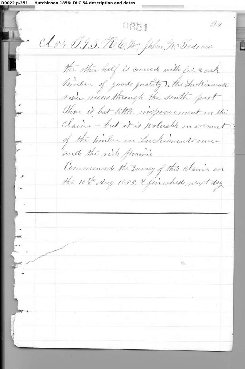
Figure 6.3. The last page of Thomas H. Hutchinson's survey of the Tedrow claim, August 1855. Read down for "fir & oak timber," "but little improvement" and "the rich prairie," then the date the survey began, "10th Aug 1855." The label printed above the page says 1856, the year in the BLM's index; the notes say 1855. Thomas H. Hutchinson, donation land claim field notes, Township 9 South, Range 6 West. Bureau of Land Management, Oregon land records, volume D0022, page 351. Public domain.
How to read it
Download the notes for every line around your sections, and read them with a pencil in hand.
The layout. On most pages the left column gives the distance along the line in chains and links, and the wide column beside it says what was there. On Murphy's page, "15 00" means 15 chains and no links: 990 feet from the corner where the line began.9
The units. Multiply chains by 66 to get feet, and links by 0.66.
Bearings. A bearing gives a direction as an angle measured from north or from south. Read "S 51½° W" as: face south, then turn 51½ degrees toward the west. A line that reads "Variation 19°15' E." records how far the compass needle pointed east of true north where the surveyor stood. Murphy's page has one.9
Random and true lines. Many lines were run twice. On the page in Figure 6.1, Murphy first ran a trial line east "on Random," set a temporary quarter-section post, and came out "17 lks. N. of post" at the far corner. Then he turned and ran back west on the "true line," setting the permanent quarter-section post "at average dist."9 The description you want is the one on the true line.
Short forms and dittos. "Qr. Sec." is quarter section, "cor." is corner, "dia." is diameter, "chs." and "lks." are chains and links, and "Udgr." is undergrowth. Ditto marks repeat the words above them: Murphy's second tree at the quarter corner is written almost entirely in dittos (Figure 6.4).9 After "Leave prairie & enter Timber" he wrote "course N & S," the direction the edge of the timber ran where he crossed it, as the instructions asked.8
The handwriting. Learn the writer's letters from words you already know, such as the township heading. Copy every word as written, misspellings included ("Tedroe," "prarie"), with the volume and page.14
Bearing trees. At each corner the surveyor blazed nearby bearing trees, also called witness trees, and recorded each one's kind, diameter, bearing and distance from the corner (Figure 6.4). The first tree at the northwest corner of the Tedrow claim was a white oak, 20 inches through, "S 23° W, 23 links." From the corner, face south, turn 23 degrees toward the west and walk 23 links (about 15 feet) to the tree. From the tree, reverse it: the corner lies N 23° E, 23 links away.15 Where no tree stood near, the notes describe a post, a charred stake or a rock, a trench and a mound, as at two corners on and near the farm.15
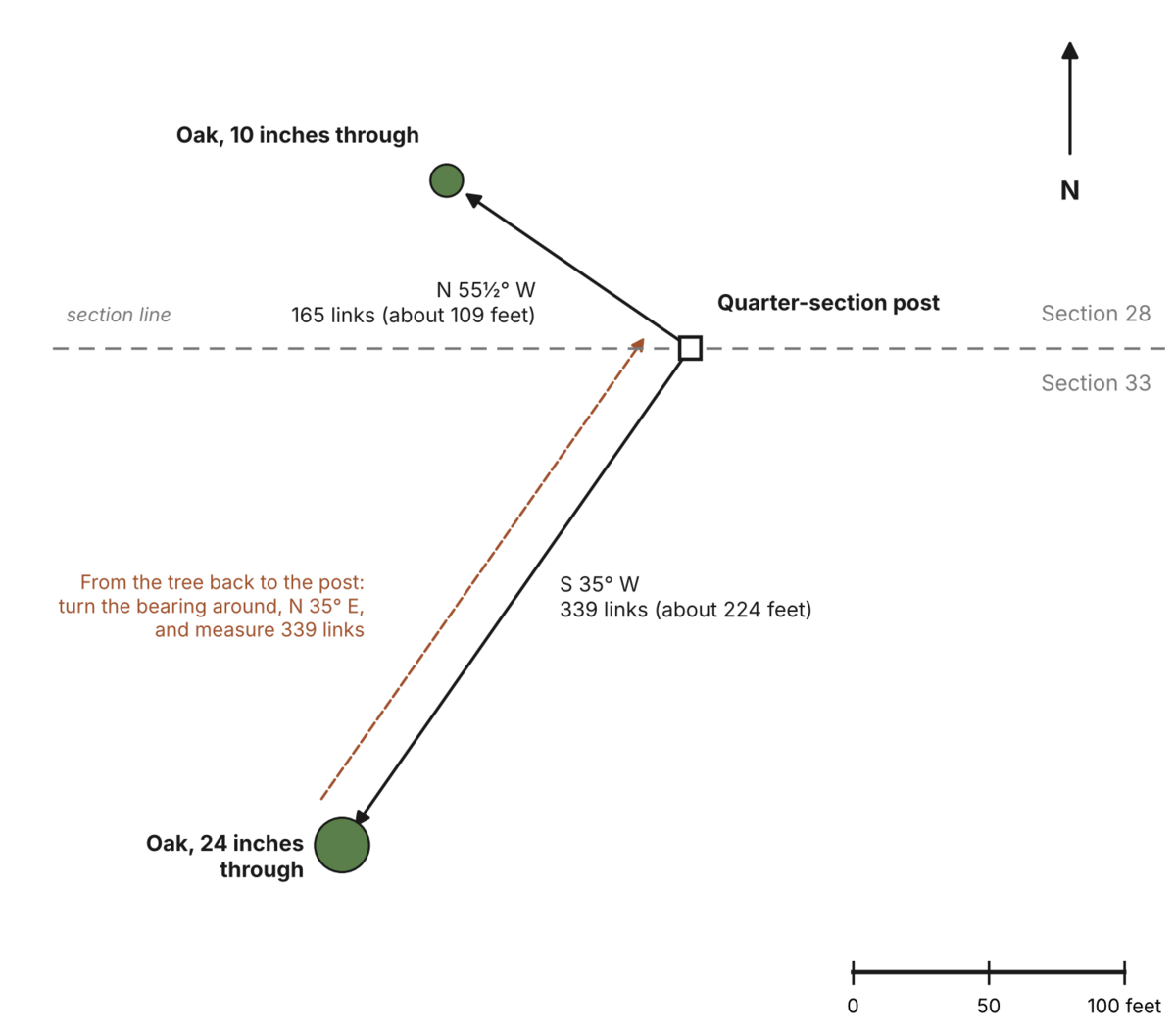
Figure 6.4. How a corner is found from its bearing trees. At the quarter corner on the line between Sections 28 and 33, Murphy recorded two oaks. One, 10 inches in diameter, stood N 55½° W, 165 links (about 109 feet) from the post; the other, 24 inches, stood S 35° W, 339 links (about 224 feet). Find either tree or its stump, turn its bearing around (S 55½° E or N 35° E), and measure the same distance back to the corner. Drawn for this guide from Daniel Murphy's field notes, 1854, BLM volume R0029, page 331.
What it costs
Nothing. The index, the plats and the scanned notes are free to search, view and download.11
A caution
The notes describe what the surveyor saw along the line he walked, not what lay between the lines.16 And the trees a surveyor marked were the ones handy to his corner. A count of bearing trees is a strong clue to the old forest, not a measurement of it.17 Read the trees beside the summary of the mile. Murphy's two quarter-corner trees on the line between Sections 28 and 33 were oaks, yet he listed the timber of that mile as "Fir Maple & oak," fir first.9 Fir was probably the commonest tree in that timber.
On the tree farm
Of the 23 trees that Murphy and Hutchinson marked at 13 corners on and near the farm, 15 were oaks: 11 white oaks and 4 noted only as "oak." The rest were 2 each of ash, alder and cherry, 1 willow and 1 "red fir," the surveyors' name for Douglas-fir.18 Count only the 16 trees at corners on or beside the farm's own lines, and the pattern holds: 13 oaks and one fir. Three of the oaks were 30 inches through, and one stood 546 feet from its corner.18 Today the same ground is almost entirely Douglas-fir plantation. Figure 6.2 shows where the trees stood.
The notes also check themselves. Fifteen chains (990 feet) along the line between Sections 28 and 33, Murphy wrote "Leave prairie & enter Timber." His summary of that mile counts the same 15 chains of prairie.19 His two sightings on the Tedrow dwelling, taken from two different points, agree within about 2 degrees.20 Nobody has yet walked the corners with the notes in hand, looking for the oaks or their stumps.20
Notes
- Daniel Murphy, field notes of the subdivision of T9S R6W, Willamette Meridian, March 1854, BLM Oregon land records, vol. R0029, as read in A History of the Land (2026), "1852 to 1854: The surveyors arrive and find neighbors." Murphy wrote "Gillam"; the later land patents read "Gilliam."
- Bureau of Land Management, Oregon State Office, survey index for T9S R6W (field notes of the outer lines, 1852 and 1853, vols. R0017, R0020 and R0029), checked October 10, 2026; A History of the Land (2026), "1852 to 1854."
- A History of the Land (2026), "1852 to 1854."
- Same, "How the old surveys worked."
- Thomas H. Hutchinson, field notes of the donation land claim surveys, T9S R6W, 1855, BLM Oregon land records, vol. D0022; dates in A History of the Land (2026), "1855: Two claims and two houses."
- Oregon-California Trails Association, Mapping and Marking Committee, "Public Land Survey System," Appendix 3 of its mapping manual; U.S. Geological Survey, "Public Land Survey System of the United States," National Atlas of the United States (2010), which covers the 30 states formed from the public domain.
- Zybach, B., How to Research Your Land's History, review draft, October 7, 2026, "The first survey: the surveyor's field notes."
- General Land Office, Instructions to the Surveyors General of Public Lands of the United States ... Containing Also a Manual of Instructions to Regulate the Field Operations of Deputy Surveyors (1855), pp. 15, 17 and 19; copy at the Bureau of Land Management, checked October 10, 2026. Murphy surveyed in 1854, the year before this edition was printed.
- Murphy (1854), vol. R0029, p. 331.
- Hutchinson (1855), vol. D0022, p. 351. The page opens in the middle of a sentence. Hutchinson wrote "goode."
- Bureau of Land Management, Oregon State Office, land records site and survey index, checked October 10, 2026.
- BLM Oregon State Office, survey index for T9S R6W, field note records 1852 to 2020, checked October 10, 2026.
- Bureau of Land Management, General Land Office Records website, site text, checked October 10, 2026.
- Murphy (1854), p. 331; Zybach, review draft, "The first survey."
- Hutchinson (1855); A History of the Land (2026), "How the old surveys worked."
- Zybach, review draft, "The first survey."
- Zybach, review draft, "One record, read with care"; A History of the Land (2026), "The witness trees."
- Murphy (1854) and Hutchinson (1855); tally in A History of the Land (2026), "The witness trees."
- Murphy (1854), p. 331. Murphy wrote "prarie."
- A History of the Land (2026), "1855: Two claims and two houses."