
Chapter 12. Photographs from the ground, the air and space
In the 1930s the Forest Service photographed the view from hundreds of its fire lookouts. On July 24, 1933, one of those cameras looked southwest from Abbott Butte, in the headwaters of the South Umpqua River (Figure 12.1). It looked across open meadows and scattered trees to the timbered ridges beyond.1 The prairies below that lookout have been photographed again and again. Two photographs of the same view were taken 111 years apart, in 1899 and 2010.2
A photograph records what was in front of the camera on one day. It is strong evidence for that day, and weaker evidence for any other.3 Put photographs of one place in date order, and they become a record of change. The tree farm's own record of change begins with the aerial photograph of 1936 in Figure 12.2.
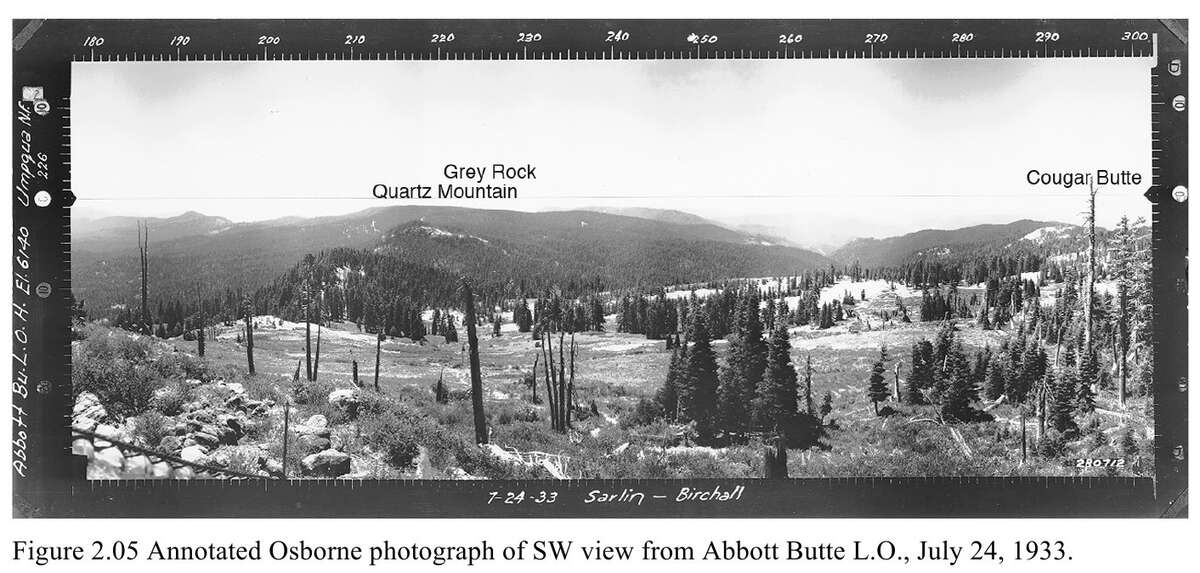
Figure 12.1. The view southwest from the Abbott Butte fire lookout, July 24, 1933. The scale across the top gives compass bearings, from 180 degrees (due south) on the left to 300 on the right. The label at the left edge gives the lookout's elevation, 6,140 feet. Look for the open meadows in the foreground and the timber around them. The place names were added later. U.S. Forest Service photograph, as printed in Bob Zybach, Tiller study (2011), Figure 2.05.
Photographs taken on the ground
What they tell you. Buildings, fences, trees, crops, roads and people, in a detail no map gives.3
Where to find them. Look in family albums first. Then try the county historical society, the state historical society and university collections. In Oregon the Oregon Historical Society, Oregon Digital and the Salem Public Library's historic photograph collection are all searchable online. For forest country, the lookout panoramas of the 1930s are scattered among several archives.4
How to read them. For each photograph, write down who took it, when, from where and in which direction, as far as anyone knows, and copy anything written on the back. If the date is unknown, the kind of photograph helps. The Graphics Atlas website explains how to tell a tintype from a cabinet card from a later print.4 Chapter 18 says more about family photographs.
Repeat photography
Repeat photography means taking an old photograph's view again from the same spot. Find the place where the old picture was taken, ask permission if it is not your land, and take the same view today. Write down the date and your exact position. Take it in the same season if you can, so that a difference in leaves is not mistaken for a difference in the land.5 The pairs from Abbott Butte show what the method can do (Figure 12.3).2
Aerial photographs
What they tell you. For most rural land in the United States, aerial photographs begin in the 1930s. They are the clearest record of clearing, planting, logging, building and regrowth over the last ninety years.6
Where to find them.
- EarthExplorer, from the U.S. Geological Survey, has federal aerial photographs from 1937 on, for the whole country. Viewing is free, and downloading needs a free account.7
- Oregon State University holds aerial photographs of Benton, Lincoln, Linn, Marion and Polk counties from 1936 to 1979, with index sheets online at Oregon Digital.6 Oregon Digital's mid-Willamette collection lists more than 1,200 items for Polk County alone.8
- The University of Oregon holds about a million aerial images of Oregon, the earliest from 1929 and most from the 1930s through the 2000s. Scans are ordered for a fee (Chapter 1 gives an example).9
- The National Archives holds the original film of the farm program flights of the 1930s to the 1950s.6
- Google Earth Pro shows a series of recent decades with its historical imagery slider. Google has said the desktop program will not be offered for new downloads after June 25, 2027, though copies already installed will keep working.10
How to read them. Find the earliest photograph that covers your land, then one from every decade after. For each, write down the date, the agency and the frame number. Pick out two or three fixed points, such as a road junction or a creek bend, and find them in every photograph before you compare anything else. On Figure 12.2 a circle inked on the print marks a section corner, a ready-made fixed point.11 A single frame is not a map. Its edges are stretched, so distances cannot be measured from it without correction.11
Old lines from the air. Survey lines of the 1850s often stay visible for more than a century as roads, fences, field edges and the edges of logged areas. In a photograph of Alsea taken in 1948, the section lines and claim lines of the early 1850s can still be picked out (Figure 4.1).12 Look for the same thing on your own land. A straight edge in the trees usually has a reason.
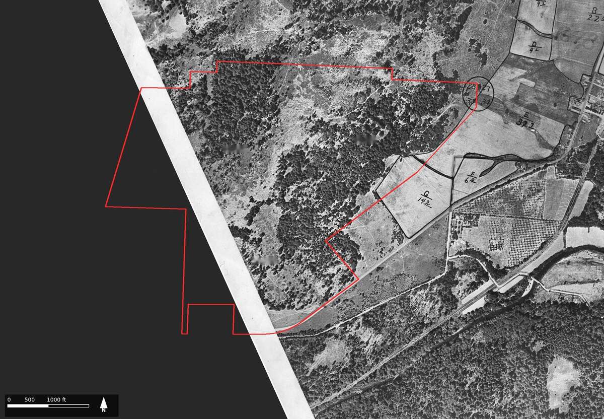
Figure 12.2. The earliest aerial photograph of the tree farm, 1936. The red line is the farm's outline, and the west side of the farm runs off the print. Inside the outline, look for the patchwork of dark tree clumps and lighter open ground. East of it are fields with acreages inked on them, orchard rows, the railroad toward Pedee, and a circle inked on the section corner beside the farm's northeast corner. U.S. Department of Agriculture aerial photograph, 1936. Oregon State University Libraries, through Oregon Digital. Outline approximate, fitted to within about 100 to 250 feet.
Satellite images
What they tell you. Satellites have photographed the whole earth again and again since the 1970s. Their pictures are coarser than aerial photographs, but they come often. That makes them good for dating a change: the year a field was cleared, a stand was cut or a fire burned.13
Where to find them. EarthExplorer holds the pictures taken by the Landsat satellites, more than 40 years of them, along with others.13 A Landsat picture shows fields and forest stands, not single buildings.
Lidar
Lidar is not a photograph, but it belongs with images. It is a laser survey from an aircraft that shows the bare ground under the trees. Old road grades, ditches, terraces and building sites that no photograph shows often stand out clearly.14 Chapter 13 explains how to find it and read it.
What it costs
Viewing is free at Oregon Digital, EarthExplorer and most historical society websites, and downloads from EarthExplorer need only a free account. Scans from the University of Oregon's collection carry a fee, and publishing one needs the library's permission and a use fee.9
A caution
A photograph that is free to view is not always free to publish. Oregon Digital marks its USDA aerial photographs "In Copyright," so ask the holder before you print a copy, or order the same frame from a public-domain source.15 And a photograph is a record of one day. Do not read a single frame as the way the land always looked.
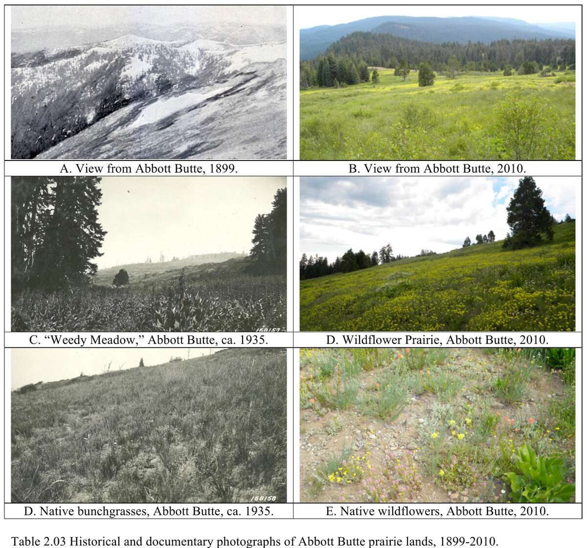
Figure 12.3. The prairies of Abbott Butte in 1899, about 1935 and 2010. The top pair is the same view, 111 years apart. Compare the open ground and the timber, then look down the page at the meadows photographed about 1935 and again in 2010. Bob Zybach, Tiller study (2011), page 32, Table 2.03.
On the tree farm
The earliest aerial photograph of the farm was taken in 1936, and it covers only about two-thirds of the land (Figure 12.2). It shows a patchwork of dark tree clumps and lighter open ground. East of the farm are fields, orchard rows and the Valley and Siletz Railroad running toward Pedee.16 Each photograph was fitted to today's map by matching roads, and even so the farm's outline fits this one, and the later ones, only to within 100 to 250 feet. That is close enough to show what grew where. It is nowhere near close enough to find a corner or a tree.17 The photographs of 1955 and 1978, which show the open grass of the grazing years and then the young plantation, carry the story on. Chapter 22 reads them in order.18
Notes
- Zybach, B., How to Research Your Land's History, review draft, October 7, 2026, "Photographs taken on the ground"; U.S. Forest Service photograph, July 24, 1933, as printed in Bob Zybach, Tiller Pre-Contact Reference Condition Study (2011), Figure 2.05.
- Zybach, Tiller study (2011), p. 32, Table 2.03; Zybach, review draft, Figure 18.
- Zybach, review draft, "Photographs, aerial photos, and satellite images."
- Zybach, review draft, "Photographs taken on the ground."
- Zybach, review draft, "Repeat photography."
- Zybach, review draft, "Aerial photographs."
- U.S. Geological Survey, EarthExplorer, site text, checked October 10, 2026; Zybach, review draft, "Aerial photographs."
- Oregon Digital, "Aerial Photos, Mid-Willamette," collection page (1,241 items for Polk County), checked October 10, 2026.
- University of Oregon Libraries, Aerial Photography Collection and Aerial Photography Research Service, checked October 10, 2026.
- Zybach, review draft, "Aerial photographs"; news reports "Google Earth Pro desktop app won't be available for new downloads starting June 25, 2027" (AlternativeTo, July 2026) and "Google Earth Pro desktop downloads will end in 2027, but existing installs will keep working" (Digital Citizen), checked October 10, 2026.
- Zybach, review draft, "Aerial photographs."
- Zybach, review draft, "What old lines can tell you"; Zybach, The Great Fires (2003), Figure 2.03.
- Zybach, review draft, "Satellite images."
- Zybach, review draft, "Lidar."
- Oregon Digital, "Aerial Photos, Mid-Willamette," rights statements, checked October 8, 2026.
- USDA aerial photograph of 1936, Oregon Digital; A History of the Land (2026), "The twentieth century, seen from the air."
- A History of the Land (2026), "The twentieth century, seen from the air."
- Same; Sullivan Tree Farm Management Plan (2012), as quoted there.