
Chapter 15. What grew there: plants, forests, fire and crops
Of the 23 trees that government surveyors marked at corners on and near the tree farm in 1854 and 1855, 15 were oaks. Only one was a Douglas-fir.1 Today the same ground is almost entirely Douglas-fir plantation.2 The records of what grew on a piece of land reach back further than any photograph, and they can show a change that no one now living has seen.
Herbarium records
What it tells you. A camas plant pressed at Monmouth on April 22, 1894, still testifies to what grew in the Polk County countryside more than 130 years ago (Figure 15.1).3 A herbarium is a library of pressed plants. Each sheet records what was collected, where, when and by whom. Taken together, they show which plants grew in an area before roads, logging and farming changed it.4
Where to find it. All of these are free.4
- The Consortium of Pacific Northwest Herbaria: more than 3 million specimen records from 55 herbaria in Oregon, Washington, Idaho, Montana, Alaska and western Canada.
- OregonFlora, from the Oregon State University Herbarium: about 4,700 kinds of plants, with a mapper that lists what has been recorded in an area you draw.
- GBIF, a worldwide index of specimens, and iNaturalist, dated photographs taken by the public, with the locations of rare species blurred on purpose.
- USDA PLANTS, which tells you whether a plant is native or was brought in.
How to read it. In the Consortium's specimen search, draw a box around your area or choose your county, and sort the results by date. Note the oldest collections, the collector, and what each label says about the place. Then list the plants on your own land and compare. Plants of open ground, such as camas and oak, deserve special attention, because they can persist long after trees close in around them (Figure 15.2).4
A caution. Old labels are often vague ("near Dallas"), and collectors favored roadsides and easy ground. A plant missing from the records was not necessarily missing from the land.4
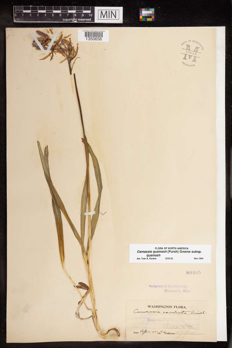
Figure 15.1. Camas collected at Monmouth, Oregon, on April 22, 1894. Read the label for the plant, the place, the date and the collector, here W. J. Spillman. A sheet like this is a dated record of what grew where. University of Minnesota, Bell Museum herbarium, specimen MIN 89465. CC0.
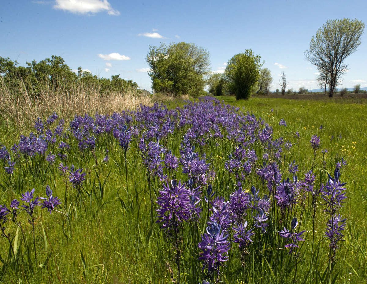
Figure 15.2. Camas in bloom at William L. Finley National Wildlife Refuge, in the Willamette Valley. Camas is a plant of open ground, and a patch of it can outlast the prairie around it. George Gentry, U.S. Fish and Wildlife Service. Public domain.
Forests, prairies and fire
What it tells you. The Willamette Valley that the surveyors walked in the 1850s held wide prairies and oak savanna, grassland with scattered oaks. Researchers who mapped its vegetation from the survey notes found that prairie and savanna dominated the southern and central valley, and that every kind of vegetation except conifer forest has shrunk since 1850.5 The burning that Native people did had kept much of that ground open, and after the 1850s much of it filled in with trees. The records show what kind of forest stood where, when it burned and when it was cut.6
Where to find it. All of these are free online.6
- The original survey notes (Chapter 6). Surveyors of the 1850s named the bearing trees at each corner, the trees they marked and measured to so that the corner could be found again. They also noted where a line left prairie and entered timber.
- Old forest maps. A 1914 map by the Oregon State Board of Forestry and a federal survey of the 1930s mapped forest types, tree sizes, burns and logged land. The 1930s maps now have a digital version (Figure 15.3).
- Maps of the vegetation of the 1850s. In Oregon, the state's biodiversity information center has mapped the vegetation the surveyors described.
- LANDFIRE, federal modeled maps of today's vegetation and of the vegetation before settlement.
- Fire records. Monitoring Trends in Burn Severity maps large fires since 1984, and the Oregon Department of Forestry publishes fire statistics for the lands it protects.
- Aerial photographs (Chapter 12), the clearest record of logging and regrowth since the 1930s.
How to read it. Start with the survey notes for the section lines nearest your land. Add the 1914 and 1930s forest maps, then the earliest aerial photograph. Put them in date order and note where the edge between open ground and trees moved.6 In the notes, count the bearing trees by kind. A corner witnessed by oaks tells a different story from one witnessed by firs.
A caution. Regional maps are general. They can be right about a county and wrong about your property.6
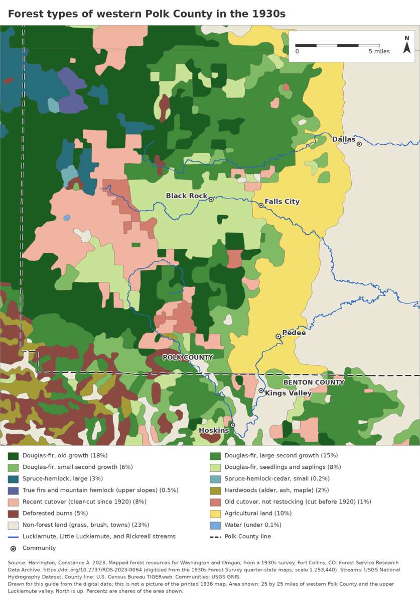
Figure 15.3. Forest types in western Polk County and the upper Luckiamute, as a federal survey mapped them between 1930 and 1936. A map like this shows the pattern for a county. Do not trust it for one property. Drawn for this guide from the U.S. Forest Service digital version of the 1930s forest type maps (2023). Public domain.
Wildlife
What it tells you. Which animals were present, which were hunted or trapped out, and which have come back. Early evidence is mostly in journals, newspapers and interviews (Chapters 9 and 18). Recent evidence is online.7
Where to find it. eBird covers birds by county and by place, iNaturalist every kind of animal, and VertNet museum specimens. In Oregon, the Department of Fish and Wildlife's Compass map shows habitats and ranges at a broad scale. All are free.7
A caution. Online sightings cluster where people like to go. A lack of records does not mean a lack of animals.7
Crops and farming
What it tells you. What was grown or grazed on a piece of land, how the work was done, and how that changed with markets, machines and transportation. Farming leaves records at three levels: the county, the neighborhood and the single farm.8 The machines changed fast. Near Walla Walla in 1902, a combine drawn by 33 horses cut, threshed and sacked wheat. In Whitman County in 1941, a tractor pulled the combine (Figures 15.5 and 15.6).9
Where to find it.
- The Census of Agriculture: county totals for crops, livestock and farm sizes from 1840 to 2012 in its online archive.
- The farm schedules of the federal census, 1850 to 1880. For those four censuses, the census taker listed each farm by the farmer's name, with its acres, livestock and crops. Oregon's are on microfilm at the Oregon State Archives and the State Library.
- CroplandCROS, which replaced CropScape: a satellite map of what was grown in each field, year by year, in recent years.
- Old soil surveys and Extension bulletins, the farm advice pamphlets of the state agricultural college. Both describe the farming of their time in plain detail.8
How to read it. Find the name of the person who owned or farmed the land in 1850, 1860, 1870 or 1880 (Chapters 7 to 9). Look for that name in the farm schedule for the same year, and read across the line (Figure 15.4). For the county picture, pull the Census of Agriculture tables for several years and note what rose and fell.8
What it costs. Free online. The Oregon farm schedules mean a trip to Salem or a request to the State Archives (Chapter 25).
A caution. County totals describe the county, not your field. The farm schedules list the farmer, who may have been a renter.8
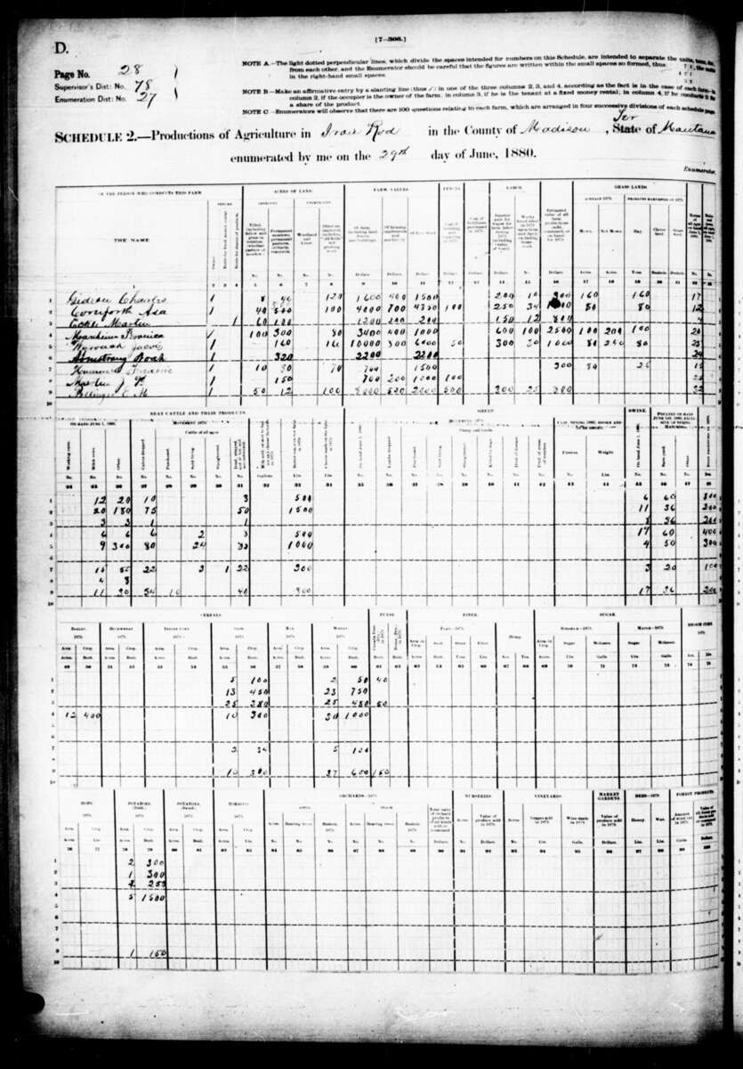
Figure 15.4. A page of the 1880 census farm schedule. Each line is one farm. Read across for the farmer's name, the acres, the livestock and the crops. This page is from Madison County, Montana Territory. National Archives microfilm M1794. Public domain.
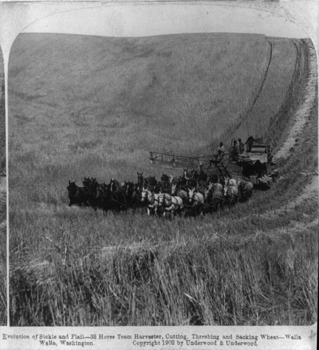
Figure 15.5. A combine drawn by 33 horses, cutting, threshing and sacking wheat near Walla Walla, Washington, 1902. One machine did three jobs, pulled by a field full of horses. Underwood and Underwood stereograph, Library of Congress. Public domain.
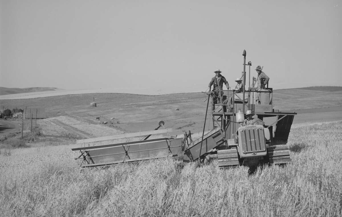
Figure 15.6. A tractor-drawn combine in the wheat fields of Whitman County, Washington, July 1941. Compare it with Figure 15.5: the same work 39 years later, with a tractor in place of the horses. Russell Lee, Farm Security Administration, Library of Congress. Public domain.
On the tree farm
The surveyors' bearing trees give the oldest picture of what grew on the farm. At 13 corners on and near it, Daniel Murphy in 1854 and Thomas Hutchinson in 1855 recorded 23 trees. Eleven were white oaks and four more were oaks of a kind not stated. The rest were two each of ash, alder and cherry, one willow, and one "red fir," the surveyors' name for Douglas-fir.1 Hutchinson's own words fill in the picture. On the Tedrow claim, which takes in most of the farm, he wrote that "the other half is covered with fir & oak timber of good quality." The claim was valuable, he added, "on account of the timber on Luckiamute river and the rich prairie." Of the Johnson claim next to it: "Three fourths of this claim is rich level prairie, one fourth is timbered."10 The picture that forms is mixed country: rich prairie dotted with oaks, and stands of fir and oak. Hold it loosely. It rests on a small sample of trees that surveyors chose to mark corners, not on a survey of the vegetation. Nor do the records say which parts of the two claims became the farm's acres.11 From the same countryside come the camas collected at Monmouth, 15 miles northeast, in 1894, and the 52,000 acres of wheat Polk County farmers were harvesting by 1879.12
Notes
- Daniel Murphy, field notes of the section lines, T9S R6W, March 1854, BLM Oregon land records, vol. R0029; Thomas H. Hutchinson, field notes of the donation land claim surveys, T9S R6W, 1855, BLM Oregon land records, vol. D0022; tally in A History of the Land (2026), "The witness trees."
- A History of the Land (2026), "December 1989 to today."
- W. J. Spillman, camas specimen, Monmouth, Oregon, April 22, 1894, University of Minnesota, Bell Museum herbarium, MIN 89465.
- Zybach, B., How to Research Your Land's History, review draft, October 7, 2026, "Plants and herbarium records."
- John A. Christy and Edward R. Alverson, "Historical Vegetation of the Willamette Valley, Oregon, circa 1850," Northwest Science 85, no. 2 (2011): 93 to 107, abstract.
- Zybach, review draft, "Forest and fire history."
- Zybach, review draft, "Wildlife."
- Zybach, review draft, "Crops and farming."
- Underwood and Underwood stereograph, near Walla Walla, Washington, 1902; Russell Lee, Farm Security Administration photograph, Whitman County, Washington, July 1941; both Library of Congress.
- Hutchinson (1855), vol. D0022, p. 351 (Tedrow claim, August 10, 1855) and his closing notes on the Johnson claim, as read in A History of the Land (2026), "1855: Two claims and two houses" and "The witness trees." The Tedrow page opens in mid-sentence; spelling regularized there.
- A History of the Land (2026), "The witness trees."
- Spillman specimen (as in note 15-3); Clarence A. Knezevich, Soil Survey of Polk County, Oregon (USDA Soil Conservation Service, 1982), as reported in the Zybach, review draft, "Crops and farming"; distance to Monmouth from A History of the Land (2026), "The land today."