
Chapter 19. Putting the pieces together
For years the management plan for the Sullivan tree farm said the land "was homesteaded around the turn of the century."1 The federal patents, the government's first deeds to the land, said otherwise, and the dates of the land laws showed why. Donation land claims, the free grants Congress offered Oregon's early settlers, could not be started after 1855, and the Homestead Act was not passed until 1862. Claims surveyed in the summer of 1855 could not have been homesteads. The family story held for about 7 of the farm's 211 acres.2
No single record settled the question. Two records disagreed, and a fact about the law explained which one to believe. That is the work of this chapter: fitting the pieces together, and saying plainly how much they prove.
Every record is a key to another
Almost every record you find gives you the key to another one. These are the links used most.
| What you find | What it leads to | Why |
|---|---|---|
| The rock under the land | The soil | Soil forms from the rock beneath it and what washes onto it. |
| The soil and the rainfall | What grew there, wild or planted | Soil and water set the limits for plants, crops and trees. |
| Township, range and section | Survey notes, plats and patents | Federal land records are filed by that description. |
| The surveyor's notes | Forest and fire history, old trails, early fields | The notes describe the ground before most of the change. |
| The first patent | The chain of deeds | The patent names the first owner, where the chain begins. |
| An owner's name and dates | Census pages, farm schedules, newspapers, gravestones, family papers | All of those are filed by name. |
| A date from a deed or a newspaper | The aerial photograph or map nearest that date | A picture shows what the words describe. |
| The date a railroad or road arrived | Changes in crops, logging and land prices | Transportation changed what the land could earn. |
| A stream gage or weather record | Newspaper accounts and people's memories | The record gives the date. The accounts say what happened here. |
| A feature in an aerial photograph or lidar image | A walk on the ground | The image says where to look. |
| A story from an interview | Every other record | A memory gives names, places and events to look up. |
The work runs in a circle: the records, the pictures, the land, the people, and back to the records (Figure 19.1). You can enter the circle anywhere. Most people enter with a name or a legal description, the wording in a deed that says exactly which land is meant, because those two open the most doors.
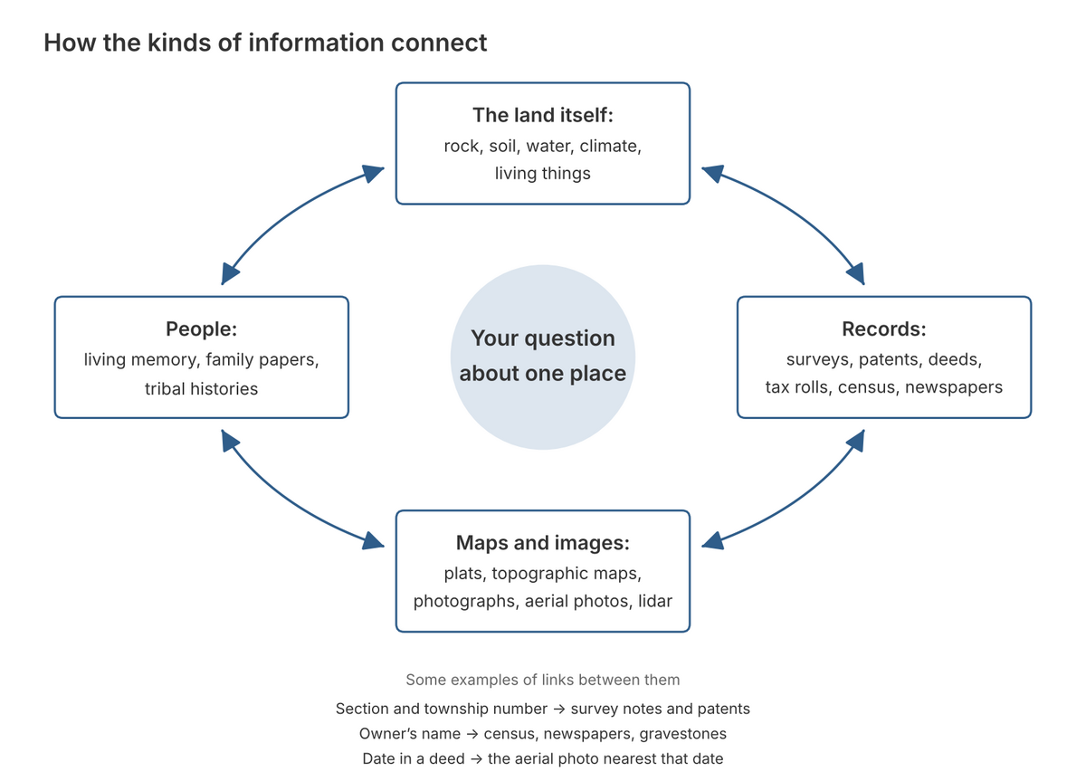
Figure 19.1. How the kinds of evidence lead to one another. Your question sits in the middle. Every arrow runs both ways: a deed can send you to an aerial photograph, and a mark on the photograph can send you back to the deeds. The 3 links listed at the bottom are the ones most people use first. Drawn for this guide.
Build a timeline
Put every dated piece of evidence in one list, in date order. For each entry give the date, what the source says, and where the source is. Keep three dates apart: the date something happened, the date it was written down, and the date of any later copy or index. They are often different, and the difference matters, as the box at the end of this chapter shows.
Do not fill the empty years with a smooth story. A gap in the timeline is a finding, because it tells you where to look next. On the tree farm, the patents of 1877 to 1900 name the first owners. Then the list of owners goes silent until a paper company planted the land about 1976, and who bought out the Tedrows and the Johnsons is not yet known.3 That gap points straight at the county deed books (Chapter 8).
When sources disagree
Disagreement is information. Before you decide which source is right, ask four questions.
- Are they describing the same place? Names move, and two creeks can share one name.
- Are they describing the same time?
- Who made each record, and for what purpose?
- Did one copy the other? Two newspaper stories that repeat one account are one source, not two.
The last question catches more mistakes than the other three. The 1855 plat, or survey map, of the farm's township letters "Level prairie and soil 1st rate" across Section 33. It looks like a second witness to the surveyor's notes. But the mapmaker drew it from those same notes, so it repeats them rather than confirming them.4
If you cannot settle a disagreement, record both versions and name the record that would settle it. Two family accounts of John W. and Rachel Tedrow disagree on whether the couple married in Ohio or in Illinois. Their donation land claim file, which should hold their own sworn statements, is the record that can decide.5
Keep more than one explanation open
A straight line of trees might be an old fence, an old road or a property edge. An opening in the forest might have been a field, a burn or a recent harvest. Write down each explanation, and beside each one the record that could confirm it or rule it out.
In 1934 the Historic American Buildings Survey drew the John Johnson house at Pedee. It may be the house the surveyor sighted on what is now the tree farm in 1855. It may instead have stood somewhere else on Johnson's claim, which reached into two other sections. The drawings themselves, kept at the Oregon Historical Society, are the record that could tell the two apart.6
Say how sure you are
Write each conclusion in three parts.
- What the sources show. "The 1948 aerial photograph shows an open field here."
- What you infer. "The field was probably cleared before 1948 and has grown back to trees since."
- What is still unknown. "I have not found when it was cleared, or by whom."
Use four plain words for how sure you are: certain, likely, possible and unknown. The tree farm has an example of each. It is certain that the Tedrows' patent was issued on June 14, 1877, because the patent says so. It is likely, but not proven, that the Charles W. Pagett buried at Montgomery Cemetery is the man who homesteaded the farm's north strip. It is possible that the house drawn in 1934 is the one the surveyor sighted in 1855. Who bought the Tedrows' land, and when, is unknown.7
A narrow statement that is true is worth more than a broad one that might be.
Keep a research log
The research log is where all of this happens. Make one entry for each source, and fill in the same items every time: your question; the place; what the source is and who made it; where you found it; the date of the event; the date the record was made; the page, frame or image number; the exact words, or what the image shows; what you think it means; what else it could mean; any limits on sharing it; and the next step, with the date you looked. Figure 2.2 shows one entry filled in, and Figure 24.1 is a blank form to copy.
Two habits make the log worth keeping. Copy the record's words exactly, misspellings and all, and put your reading of them on a separate line. And write down where you found each thing on the day you find it. Six months later, "a government website" will not lead you back to a page. "BLM Oregon land records, volume R0029, page 331" will.
Before you share
Keep a private copy of everything, and make a separate copy for sharing. Then check what is in the sharing copy. Leave out the locations of archaeological sites and burials (Chapter 16). Follow whatever each person you interviewed agreed to (Chapter 18). Check the rights to any photograph you did not take. This guide follows its own rule. It describes the two 1855 house sites on the tree farm by the surveyor's bearings and distances, as the notes give them, and never draws them on a map.
On the tree farm
One survey on the farm carries two dates, and its history had to choose between them. Thomas H. Hutchinson's field notes for the Tedrow claim end with the date "10th Aug 1855." The Bureau of Land Management's index of surveys for the township lists the same work under 1856, and a label printed above the scanned page repeats 1856.8 The notes were written in the field, on the days the surveyor did the work. The index and the label came later. When a record made at the time and a later copy disagree, follow the record made at the time, as the farm's history does.9
The 1955 aerial photograph is a chance to practice the three-part statement. What it shows: open grassland with scattered trees, crossed by tracks, with denser timber in the northeast and on the west side. What can be inferred: the owner's management plan says the land was fenced and grazed by cattle before he bought it, and the photograph fits that account. What is still unknown: to the eye the farm looks more open in 1955 than in 1936, but no record of logging or clearing has turned up, so the change stays a question, not a finding.10
Notes
- Sullivan Tree Farm Management Plan (2012), as quoted in A History of the Land (2026), opening section.
- A History of the Land (2026), "1871 to 1900: Railroad land and a seven-acre homestead," patent table and the paragraphs after it, which record Bob Zybach's correction; Homestead Act of May 20, 1862, 12 Stat. 392.
- A History of the Land (2026), "1855: Two claims and two houses," "1871 to 1900" and "The twentieth century, seen from the air."
- General Land Office plat of T9S R6W, Willamette Meridian, approved May 1, 1855, BLM Oregon State Office; drawn from Daniel Murphy's field notes of 1854, as A History of the Land (2026) explains in "1852 to 1854: The surveyors arrive and find neighbors."
- A History of the Land (2026), "1855: Two claims and two houses" and "Next steps for this property"; the two family accounts are listed in its annotated bibliography.
- A History of the Land (2026), "The twentieth century, seen from the air" and "Next steps for this property"; Oregon Historical Society Research Library, Mss 3100, John Johnson residence plans (1934), catalog entry.
- The patent: Bureau of Land Management, General Land Office Records, as listed in A History of the Land (2026), "1855: Two claims and two houses." Pagett: Polk County Pioneer Cemeteries, Montgomery Cemetery records, as cited in the same report, "1871 to 1900." The house of 1934 and the Tedrow sale: the same report, "The twentieth century, seen from the air" and "1855: Two claims and two houses."
- Thomas H. Hutchinson, field notes of the donation land claim surveys, T9S R6W, 1855, BLM Oregon land records, vol. D0022, p. 351; BLM Oregon State Office, land records survey index for T9S R6W.
- A History of the Land (2026), "1855: Two claims and two houses."
- USDA aerial photographs of Polk County, 1936 and 1955, Oregon Digital; Sullivan Tree Farm Management Plan (2012); both as read in A History of the Land (2026), "The twentieth century, seen from the air."