
Chapter 8. Deeds, tax rolls and the chain of owners
When the main tract of the Sullivan tree farm was surveyed in 1993, the surveyor listed three old rights that still went with the land. The first reads: "Reservation of mineral rights, water rights, and rights-of-way per Vol. 27, Page 70, Polk Deed Rec." It touches only the part of the farm in Section 28 (Figure 8.1).1 Somebody, at some time, sold that land and kept those rights back. The survey does not say who or when. The deed in Volume 27 of the county's deed records, at page 70, will.
Deeds are the thread that runs from the first patent to today. Each one names a seller and a buyer, and each points back to the one before it.
What it tells you
A deed records the passing of land from one owner to the next. The seller is the grantor and the buyer the grantee.2 Along the way deeds mention prices, family relationships, buildings, roads, water rights, timber sales and rights the seller kept back.2 A right kept back by a seller is a reservation. A right that lets someone else use the land, such as a road, a spring or a power line, is an easement.
The county assessor's records tell a different part of the story. They give the land's present description, its acreage, its recent sales, and the year the assessor believes each building was built. Old assessment rolls list who paid tax on which land, year by year, and they can fill gaps in a chain of deeds.3
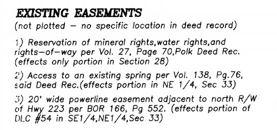
Figure 8.1. Three old rights listed on a modern survey. The 1993 survey of the tree farm cites each one by book and page: a "Reservation of mineral rights, water rights, and rights-of-way" in Volume 27, page 70; "Access to an existing spring" in Volume 138, page 76; and a 20-foot powerline easement in Book of Records 166, page 552. None is drawn on the map, because the deeds give "no specific location." Each book and page is a door into the county's deed records. Partition Plat No. 1993-0029, June 24, 1993 (detail, "Existing easements"). Polk County Surveyor, survey CS 12769.
Where to find it
Deeds are recorded in the county where the land lies, by the county clerk (in some counties called the recorder). The clerk keeps indexes by the grantor's name and by the grantee's name, year by year. Each index entry gives a book and page.2
How far back you can search from home depends on the county.
- Polk County. The clerk's index runs online from 1984 to the present, and scanned deed books and index books cover the county's earlier years. They open through the county's Digital Research Room, which asks you to accept a disclaimer first.4
- Benton County. The online index runs from 1966 to the present, and it is an index only: the deeds themselves come by request or in person. The deed index for 1848 to 1966 can be searched only in person.5
Some counties have no online index at all; none was found for Linn County, where you ask in person or by mail.6 Where the county has none, try FamilySearch, which has filmed deed books for many counties. A free account is needed. Its full-text search can find names in handwritten deeds, though it often misreads them.6
For the assessor, start with the county's online property search (Chapter 3). For old assessment rolls in Oregon, the Oregon State Archives' County Records Guide says which years survive for each county and where they are kept.3 If the chain breaks at an owner's death, look for an estate. The Archives' Oregon Historical Records Index covers estates, early censuses and tax rolls.7 Chapter 25 lists all of these offices.
How to read it
Work backward, one owner at a time. Start with the current deed. Find the seller's name, then look in the grantee index for the deed by which that seller acquired the land. Repeat. For each deed write down the date, both names, the book and page, and anything said about the land. When you reach the patent, the chain is complete.8
Read what each instrument is. Not every recorded paper is a sale. A correction deed, a mortgage or an easement may sit in the same index under the same names.9 Read the heading before you add it to your chain.
Expect the books to change names. One survey of the tree farm cites the same county's records as "Vol. 27," "Book 232, Page 314, Polk County Book of Records" and "BOR 166."1 Ask the clerk's office which series covers which years.
Follow every piece. Land put together from several first owners has several chains, one for each piece, until they meet under one owner. On the tree farm the county's tax lots and the first owners line up like this:10
| Tax lot (today) | First owner after the United States | Patent | Acres (about) |
|---|---|---|---|
| Most of 200, 206 and 207 | John W. and Rachel Tedrow, donation land claim 54 | 1877 | 150 |
| East part of 207 | John Johnson, donation land claim 53 | 1877 | 12 |
| 304 | Oregon and California Railroad | 1897 and 1899 | 31 |
| "Gov't Lot 1," inside 207 | Oregon and California Railroad (inferred) | 1871 | 7 |
| North strip of 206 and 207 | Charles W. Pagett, homestead | 1900 | 7 |
The acreages are estimates from county map layers. That is 5 chains to trace, not one.
Read the assessor's dates with care. The assessor's "year built" is often an estimate. Check it against deeds, maps and newspapers.3
What it costs
Searching an online index is free. Copies of recorded documents carry a fee, set by each county. Indexes that are not online cost a trip to the courthouse or a letter.5
A caution
A history of ownership is not a title search. It will not find every lien, easement or defect, and it should not be used for a sale or a dispute.11 It tells you who owned the land. It does not tell you who owns it now, or what rights others hold in it; for that, see a title company.
On the tree farm
In 1993 the main tract of the farm, then tax lot 200 on county map 9-6-33, was surveyed and divided into three parcels. They are today's tax lots 200, 206 and 207. Lot 304, the railroad land on the west side, is a separate tract.12 That survey hands a researcher the first links of the chain. It names the deed by which the land was conveyed to Dave Sullivan: "Book 232, Page 314, Polk County Book of Records." It also cites a county survey of 1960 that controlled most of the old boundary, and the three older rights by book and page.1 The management plan carries the story back a few more years. Publishers Paper sold the land to WTD Industries in 1988. WTD logged nearly all the merchantable timber in the spring of 1989 and that December sold the land to Dave Sullivan.13 One later record is easy to misread. The county's 1996 instrument for the farm is a correction deed, not the purchase.14 Between the patents of 1877 and the sale of 1989 lies more than a century that nobody has traced yet. Who bought the land from the Tedrows is still unknown.15
Notes
- Partition Plat No. 1993-0029, June 24, 1993, "Existing easements," narrative and surveyor's certificate. Polk County survey CS 12769. The plat says the reservation "effects only portion in Section 28" and that the easements are "not plotted," with "no specific location in deed record."
- Zybach, B., How to Research Your Land's History, review draft, October 7, 2026, "Deeds and the chain of owners."
- Zybach, review draft, "Tax lots and assessor records"; Oregon State Archives, County Records Guide, checked October 10, 2026.
- Zybach, review draft, "Deeds and the chain of owners"; Polk County, Digital Research Room, checked October 10, 2026.
- Benton County Records, "Real Property Records" and "Records Requests and Fees," checked October 10, 2026.
- Zybach, review draft, "Deeds and the chain of owners."
- A History of the Land (2026), "Researching your own land's history," step 6.
- Zybach, review draft, "Deeds and the chain of owners."
- A History of the Land (2026), "Researching your own land's history," step 7; Benton County Records, "Real Property Records" (an index of "recorded deed, mortgage and lien records"), checked October 10, 2026.
- A History of the Land (2026), "1871 to 1900: Railroad land and a seven-acre homestead," patent table, from BLM General Land Office Records, the BLM historical index for T9S R6W and Polk County map layers retrieved October 2, 2026.
- Zybach, review draft, "Deeds and the chain of owners."
- A History of the Land (2026), "1871 to 1900" and "December 1989 to today: becoming a tree farm"; Partition Plat No. 1993-0029, narrative.
- Sullivan Tree Farm Management Plan (2012), as summarized in A History of the Land (2026), "December 1989 to today."
- A History of the Land (2026), "Researching your own land's history," step 7.
- Same, "The Tedrows" and "Next steps for this property."