
Your Land History: The User's Manual
How to Make and Read Your Own Property Report
Prepared by the Your Land History project. Edition 1.1, October 2026.
About this edition
This is the adult edition of the manual for the website Your Land History, version 1.1, written for someone who has never seen the site. It is the first edition; a Kids edition and a Professional edition may follow, made from this one. A companion book, Knowing Your Land: A Reference Guide to Researching Your Land's History, by Bob Zybach, explains the records behind every report; a table at the back of this manual matches each part of a report to its chapter.
Acknowledgments
Your Land History is a project of Dr. Bob Zybach and Dr. Dave Sullivan. The research method comes from Oregon Websites and Watersheds; the idea began in the library of Oregon Advocates for School Trust Lands. Both are thanked here, because what the site knows how to look for comes from their work.
Every report is built from public records kept by the Bureau of Land Management, the U.S. Geological Survey, the Natural Resources Conservation Service, the National Oceanic and Atmospheric Administration, the Oregon Department of Geology and Mineral Industries, the Oregon State Archives and Oregon's county offices. Their records are open to everyone, which is why the site can exist.
Contents
Who this manual is for
The example in this manual
Before you start
Part 1. Making your report
Part 2. Reading your report
- The opening and "This land today"
- The record behind every sentence
- The ground
- Water and weather
- The people before the surveyors
- The surveyors arrive
- First owners
- The families
- Seen from above
- Getting here
- Timeline
- If you're hooked: what to do next
- About this report: the appendix
Part 3. Doing more
- Detail and Written for
- Look deeper into this
- Everything we can look for
- My research list
- Printing a report and saving it as a PDF
- Copy my link
- My land, Forget this land and Larger text
Part 4. When something goes wrong
Part 5. Questions people ask
At the back
The words used · Where to read more in Knowing Your Land · About this manual
Who this manual is for
In March 1854 a government surveyor walking a section line near Pedee, Oregon, wrote four words in his notebook: "Leave prairie & enter Timber."1 Anyone can still read that notebook, and the map drawn from it, and the paper that passed the land to its first private owner. Your Land History gathers records like these for one piece of Oregon land and writes them up as a story you can follow. This manual shows you how.
It was written with three readers in mind.
The landowner with a tax statement. You own a house lot, a farm or a woodlot, and you want to know what was there before you. Your tax statement holds everything you need to start ("Before you start" shows where).
The family member with a story. Your family has always said that great-grandfather homesteaded the place, or that the old barn stood on a pioneer's land claim. You want to see whether the records agree. Sometimes they do. On the land that runs through this manual, they did not: the farm's own management plan said "homesteaded," and the records said that homesteading accounts for about 7 of its 211 acres.2
The student with a schoolyard. Your class wants to know what the ground under the school looked like before the town was there. The school's address, or its township, range and section, is enough.
You may be reading on a phone, in a field or a county office, and you may prefer large type. The site was designed for that. Every button works with one thumb, and Larger text makes the words bigger. On a wide screen it is at the top of every page; on a phone, touch Menu, then Larger text.
How to read this manual. Part 1 takes you from the front page to a finished report. Part 2 walks through a finished report, part by part. Part 3 covers the controls for doing more, Part 4 what to do when something goes wrong, and Part 5 the questions people ask most. Read it in any order.
Words you see on the screen are printed here in bold, spelled exactly as the site spells them, like Find my land. Messages the site shows are printed in quotation marks. Where a message includes your own numbers or names, this manual shows the place where they go in square brackets, like "Township [number] [North or South]."
The example in this manual
Almost every example in this manual comes from one real place: the Sullivan tree farm near Pedee, at 12875 Kings Valley Highway in Polk County. It is about 211 acres of Douglas-fir in the Coast Range foothills, in Sections 28 and 33 of Township 9 South, Range 6 West, Willamette Meridian. Dave Sullivan has owned it since December 1989.3 It is also the site's public sample report, which anyone can open from the front page.
We use it for a plain reason. Researching this farm's history with Bob Zybach, in October 2026, is what gave us the idea for the whole site. In the software business, using your own product on your own work is called "eating your own dog food." That is why the farm appears on nearly every page of this manual.
The farm is ordinary in the best way. It has the records much western Oregon land has: survey notes from the 1850s, two pioneer land claims, railroad grant land, a small homestead, aerial photographs from 1936 on, and gaps that only a trip to the county will fill.4 Where the manual says "In the sample report," it is showing you what the site found for this farm, and every fact in that box can be found on the sample's own pages. A few boxes are headed "From the farm's own history (not in the sample report)." They add what was found by hand, beyond the report; Knowing Your Land, Chapter 22, tells that longer story.
The sample is the same for everyone, so it has none of the buttons that appear only on reports you make yourself. The few pictures of those buttons, and of a report while it builds, show an area history made for this manual of the farm's own main section, Section 33, Township 9 South, Range 6 West. Most of that section lies inside two 1850s land claims, so the site outlined the parts of it outside them, about 185 acres, and wrote the history of that ground.
Before you start
Most Oregon land can be found from one line of a property tax statement. You need one of three things, and you probably have at least one of them in a drawer.
Three ways to say where your land is
| What you have | What it looks like | Where it is printed |
|---|---|---|
| Legal description | "The SE¼ of the NW¼ of Section 33, Township 9 South, Range 6 West, Willamette Meridian," or a claim or lot by number | Your deed. Title papers from when you bought the land. Sometimes in short form on the tax statement, like "Sec 33 T9S R6W." |
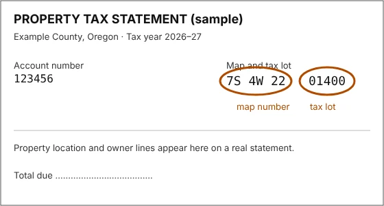
| Tax lot | A county, a map number like "7S 4W 22," and a tax lot like "01400" | Your property tax statement, usually near the top. The labels differ from county to county. Look for words like "map and tax lot" and "map/TL." The statement's account number is not used yet. |
| Street address | "123 Main Street, Monmouth, Oregon" | Anywhere. It works best in town. Farm and timber land often has no street address the federal address list knows. |
These examples are made up, except the township, range and section in the legal description, which are the sample farm's.
If you have more than one, use the legal description or the tax lot. They find your land itself; a street address finds a point, and the site writes about the land around it.
If you have none of them, ask the county assessor's office, or use your county's free property search online, or Oregon's statewide tax-map viewer, ORMAP. Or find your land on a map (Chapter 1).
What it costs
Nothing. There is no account to open, no payment and no email address to give. An office or archive that you visit later, following the report's suggestions, may charge for its own copies.
What else you need
A phone, tablet or computer with a web browser. There is nothing to install. The site works on slow country connections, though pictures take longer.
What the site does not do
The site tells the history of a piece of land. It does not search titles, survey boundaries or put a value on land. For who owns the land today and where its legal lines run, ask a title company or a licensed land surveyor; for what it is worth, ask an appraiser. Old records can explain a great deal about a property, but they cannot settle a dispute about it.
Notes
- Daniel Murphy, field notes of the section lines, Township 9 South, Range 6 West, Willamette Meridian, March 1854. Bureau of Land Management, Oregon land records, volume R0029, page 331. Murphy wrote "prarie." ↩
- A History of the Land: The Story of the Sullivan Tree Farm near Pedee, Polk County, Oregon (October 2026), opening and "1871 to 1900: Railroad land and a seven-acre homestead." ↩
- A History of the Land (2026), "The land today." ↩
- A History of the Land (2026), "1855: Two claims and two houses," "1871 to 1900" and "The twentieth century, seen from the air." ↩