
Chapter 7. How the land left the government
Along the north edge of the Sullivan tree farm runs a strip of land about 138 feet wide.1 Three homestead entries were made on the tract it belongs to, in 1881, 1886 and 1887. All three were cancelled, the last in October 1894, and the federal index names no one. Then came Charles W. Pagett. On October 12, 1900, he received a patent for 104.35 acres there, and the strip passed into private hands.2
What it tells you
Every acre of public land left the government under some law, on some date, to someone. The record of that first transfer is the patent, the government's first deed to the land. Behind many patents is a file of sworn statements by the settler and the neighbors.3 And as the north strip shows, the tries that failed left records too.
The ways land left federal hands
Donation land claims. Oregon's earliest grants were donation land claims, free land for settlers under an act of Congress approved September 27, 1850.4 Because settlers chose their land before the surveyors came, claim lines often cut across section lines (Figure 7.1). A married couple's claim was divided between them. The patent for the Welch claim, in the same township as the farm, gives "the north half" of its 641.02 acres to Andrew J. Welch and "the south half" to "his wife the said Martha Welch," his half to his heirs and hers to hers (Figure 7.2).4 No new claims could be started after 1855.5
Homesteads and cash sales. After the donation claims came homesteads, under the Homestead Act of 1862, and cash sales of public land.6 A homestead began as an entry and ended, if all went well, with a patent. An entry could also be cancelled, like the three on the farm's north strip.2
Railroad and wagon road grants. Congress also paid for railroads and wagon roads with land.6 In 1866 it made a land grant to promote the rapid completion of two railroads in western Oregon. Much of that land was deeded to the Oregon and California Railroad Company, the O&C. In 1916 Congress took back, or revested, the title to about 2.9 million acres of it, because the company had broken the grant's terms. Under the O&C Act of 1937 the Bureau of Land Management (BLM) still manages the O&C lands, more than 2.4 million acres of forest.7 A railroad's patents sit in the federal records like anyone else's.
School sections. When Congress admitted Oregon as a state on February 14, 1859, it offered the new state "sections numbered sixteen and thirty-six in every township of public lands in said State" for the use of schools. Where one of those sections had already been sold or otherwise disposed of, the state was to get other land "equivalent thereto." Oregon accepted on June 3, 1859.8 Many other states received similar school grants.6 If your land lies in Section 16 or 36 (Figure 3.1), its first private owner may have bought it from the State of Oregon, not the United States. Records of the state's school land sales are at the Oregon State Archives.9 If a settler's claim already covered the section, the state took other land instead, and the federal records will show the claim.
The file behind the patent
A patent is a single page. The file behind it may hold the settler's own sworn statements and those of neighbors.3 For Oregon's donation claims, those files are on National Archives microfilm M815, free to view on FamilySearch. They can settle questions no other record answers: when a couple married, which of two men with the same name held the claim.10 Homestead and cash entry case files are kept by the National Archives and ordered from it.11
Where to find it
- The BLM's General Land Office Records website has the patents, searchable by name or by township. It tells you who received each piece, when, and how many acres.12
- The BLM Oregon State Office's land records site has a Historical Index for each township. It is the place to find the entries that failed and the patents that were later changed.12
- The Genealogical Forum of Oregon keeps an index of Oregon's donation land claims.13
- FamilySearch has the donation claim files (microfilm M815) and many filmed land records.
- The National Archives has the homestead and cash entry case files.
- The Oregon State Archives has the records of state school land sales.
Chapter 25 gives the addresses.
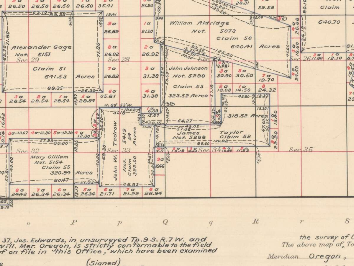
Figure 7.1. The donation land claims of Township 9 South, Range 6 West. Each claim carries its owner's name, number and acreage. Find John W. Tedrow's claim, No. 54, running up the middle, and John Johnson's, No. 53, to the northeast. The claims ignore the section lines, and the scraps left between claim lines and section lines are numbered as lots. The small lot marked 6.93 acres, just right of the top edge of the Tedrow claim, now lies in the tree farm's northeast corner. General Land Office donation land claim plat of T9S R6W, Willamette Meridian. Bureau of Land Management, Oregon State Office. Public domain.
How to read it
A patent names the law, the person, the land and the date (Figure 7.2). For a donation claim the land is described by metes and bounds, a starting point and then a walk around the edge by bearings and distances. The Welch patent begins "at a point two and eighty-eight-hundredths chains north of the southwest corner of said Section twelve."4 Copy the certificate number and the patent number. They are the keys to the file.
Read every index entry for your township, not only the ones with your section in them. A claim can cross into a neighboring section, and an entry can describe a lot by number rather than by quarter. Watch for the words "cancelled," "reconveyed" and "revested." They mean the land did not stay where the first entry put it.14
To check whether your land was school land, look at the section number. Sections 16 and 36 sit in opposite corners of the township (Figure 3.1).
What it costs
The BLM's patent records and indexes are free, and so is the Genealogical Forum's claim index. The claim files on FamilySearch need only a free account. A case file from the National Archives is ordered for a fee. An image of a patent that has not been scanned can be requested from the BLM Oregon State Office's public room.15
A caution
These records show only the first transfer. Everything after it is in the county (Chapter 8). A patent is a historical record. It tells you who first received the land from the government, not who owns it now.16
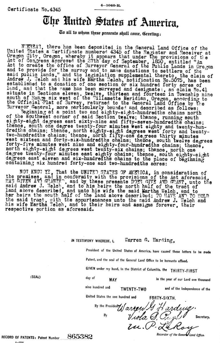
Figure 7.2. A patent, the government's first deed. This one passes the Welch donation claim, 641.02 acres in the tree farm's township, to Andrew J. Welch and his wife Martha: "the north half" to him and "the south half" to her. Find the act of September 27, 1850, near the top, and the patent number, 865382, at the bottom left. The patent is dated May 31, 1922. For most Oregon patents of the 1870s only the index entry is online, not an image like this one. Bureau of Land Management, General Land Office Records, patent 865382. Public domain.
On the tree farm
The farm's 211 acres left federal hands under three different laws, by five patents and probably a sixth.17 About 150 acres lie in the Tedrow claim, No. 54, whose patent was issued on June 14, 1877. About 12 acres on the east side lie in the Johnson claim, No. 53, patented the same year.17 Thirty-one acres on the west side went to the O&C Railroad by patents of January 30, 1897, and November 29, 1899. The northeast lot, the 6.93-acre scrap that no claim covered, appears to have gone to the railroad too, by O&C patent No. 2 of July 12, 1871. "Appears" is the right word. The federal index says that patent was partly reconveyed in 1887 and partly revested in 1916 without saying which land, and nobody has yet looked at the patent itself.18 Only the 7-acre north strip was homestead land, so the management plan's "homesteaded around the turn of the century" was wrong for about 97 percent of the farm.19 The farm lies in Sections 28 and 33, so none of it was ever school land.
Notes
- A History of the Land (2026), "1871 to 1900: Railroad land and a seven-acre homestead."
- Same; Bureau of Land Management, General Land Office Records, homestead patent to Charles W. Pagett, October 12, 1900; BLM historical index for T9S R6W.
- Zybach, B., How to Research Your Land's History, review draft, October 7, 2026, "First title: patents, claims, homesteads, and grants."
- U.S. patent 865382 to Andrew J. Welch and Martha Welch, donation claim No. 41, T9S R6W, May 31, 1922, under the act of September 27, 1850. BLM General Land Office Records.
- A History of the Land (2026), "1871 to 1900"; Zybach, review draft, "The story that needed correcting."
- Zybach, review draft, "First title"; A History of the Land (2026), "1871 to 1900."
- Bureau of Land Management, "History of the O&C Act" (flyer), checked October 10, 2026.
- Act of February 14, 1859, 11 Stat. 383, section 4, first proposition, and Oregon's act accepting the propositions, approved June 3, 1859, both as printed in Oregon State Legislature, "Oregon Admission Acts," checked October 10, 2026.
- Zybach, review draft, "First title."
- A History of the Land (2026), "Next steps for this property"; FamilySearch, checked October 10, 2026.
- National Archives, "Land Records" research page, checked October 10, 2026; Zybach, review draft, "First title."
- A History of the Land (2026), annotated bibliography, entries for the BLM survey index and the General Land Office Records database; Bureau of Land Management, Oregon State Office, land records site, checked October 10, 2026.
- Genealogical Forum of Oregon, website, checked October 10, 2026; Zybach, review draft, "First title."
- BLM historical index for T9S R6W, as read in A History of the Land (2026), "1871 to 1900."
- A History of the Land (2026), "Next steps for this property"; Zybach, review draft, "First title."
- Zybach, review draft, "First title."
- A History of the Land (2026), "1855: Two claims and two houses" and "1871 to 1900," patent table, from BLM General Land Office Records and the BLM historical index for T9S R6W. Acreages are estimates from county map layers.
- A History of the Land (2026), "1871 to 1900."
- Sullivan Tree Farm Management Plan (2012), as quoted in A History of the Land (2026), opening section; Zybach, review draft, "The story that needed correcting."