
Chapter 25. An Oregon directory of offices and websites
Most of what this guide describes is kept in about thirty places, and you can search most of them from home without paying anything. This chapter lists them, grouped the way the work usually goes: the federal land records first, then the state's archives and libraries, the maps and data about the land itself, the counties, the records of people, and the tribal nations and the state's archaeology office. Each entry says what the office or website holds, how to search it, what it costs, where it is, and how it served the tree farm near Pedee.
Federal land records
Bureau of Land Management, General Land Office Records
What it holds. "Federal land conveyance records for the Public Land States": land patents issued from 1788 to the present, with images of millions of them, and images of survey plats and field notes. How to search. Choose the state, then search by a person's name or by the land's township and range. Cost. Free. Website. glorecords.blm.gov. On the tree farm. The patents for the two donation land claims (1877), the railroad grant land (1897 and 1899) and the Pagett homestead (1900) all came from here.1
Bureau of Land Management, Oregon/Washington State Office
What it holds. For every township in Oregon and Washington: the Master Title Plat, which maps today's federal land; the Historical Index, which lists every entry, sale and patent, including the ones that failed; and the survey plats and field notes, with scans online. How to search. Choose the township and range. The survey index lists each survey and plat with its dates, and the field-note volumes open as page scans. Cost. Free online. The public room makes copies of plats, field notes, title records and case files, and helps with research. Where. Public room, Edith Green-Wendell Wyatt Federal Building, 11th floor, 1220 SW 3rd Avenue, Portland, OR 97204; 503-808-6008; blm-orwa-public-room@blm.gov; walk-in Monday to Friday, 9 a.m. to 4 p.m. Website. blm.gov/or/landrecords. On the tree farm. Murphy's notes of 1854 (volume R0029) and Hutchinson's of 1855 (volume D0022) are read here, and the Historical Index lists the three failed homestead entries on the farm's north strip.2
National Archives: land entry files and the census
What it holds. The case files behind federal land entries (homestead, cash, credit and mineral), and the federal census from 1790 to 1950. Census pages are opened to the public 72 years after the count, so the 1950 census was released on April 1, 2022; its own website searches more than 6.5 million population schedules by name or by place. How to order. Land entry case files are ordered with form NATF 84 or through the Archives' online ordering system. Oregon's donation land claim files are on National Archives microfilm M815, free to view through FamilySearch (below). Cost. The 1950 census website is free. Website. archives.gov/research/land; 1950census.archives.gov. On the tree farm. Charles W. Pagett's homestead case file, final certificate 5919, is the farm's next order.3
State archives, libraries and historical societies
Oregon State Archives
What it holds. "Oregon's permanently valuable government records," including old assessment rolls for some counties and years. Its Oregon Historical County Records Guide inventories the surviving records of each of Oregon's 36 counties and says where each series is kept: at the Archives, at the courthouse or at a local museum. How to search. Open the County Records Guide, choose your county, and read the inventory for deeds, assessment and tax rolls, road records and estate files. Then ask the reference staff about copies or an appointment. Where. Cecil L. Edwards Archives Building, 800 Summer Street NE, Salem, OR 97310; 503-373-0701; Monday to Friday, 8 a.m. to 5 p.m., by appointment. Website. sos.oregon.gov/archives. On the tree farm. Polk County's inventory shows assessment rolls for scattered years from 1892 to 1940 at the Archives, and the county's earliest listed roll, for 1866, at the Polk County Historical Society.4
Oregon Historical Society Research Library
What it holds. "Thousands of books, maps, manuscripts, serials, vertical files, newspaper microfilm" about Oregon. Cost. "There is no charge for admission to the Research Library." Where. 1200 SW Park Avenue, Portland, OR 97205; research library voicemail 503-306-5240. On October 10, 2026, the library's web page still described the reading room as closed for renovation, so call before you plan a visit. Website. ohs.org/research-and-library. On the tree farm. Manuscript collection Mss 3100 holds the 16 drawings of the John Johnson house at Pedee that the Historic American Buildings Survey made in 1934.5
Oregon State University, Special Collections and Archives Research Center
What it holds. Manuscripts, archives, photographs and books, collecting especially in natural resources and the university's own history, with an oral history program. Its collections include Sanborn fire insurance maps of Oregon towns from 1879 to 1956 and the Gerald W. Williams forest history photographs (Figure 20.2). How to search. Collection guides, called finding aids, on its website and in Archives West; digitized items through Oregon Digital. Where. 121 The Valley Library, fifth floor, Oregon State University, Corvallis, OR 97331; 541-737-2075; open by appointment only. Website. scarc.library.oregonstate.edu. On the tree farm. The aerial photographs of the farm from 1936, 1955 and 1978 are this library's, seen through Oregon Digital.6
Oregon Digital
What it holds. The shared digital collections of Oregon State University and the University of Oregon. Its "Aerial Photos, Mid-Willamette" collection holds U.S. Department of Agriculture aerial photographs from the 1930s to the 1970s: 1,241 items for Polk County, 1,831 for Benton and 2,403 for Linn, among other counties. How to search. Open the collection and narrow it by county and decade, or search a place name; frames are tagged by place. Cost. Free to view. Before you publish a picture, ask the library that holds it. Website. oregondigital.org. On the tree farm. The farm's three earliest aerial photographs (Chapters 12 and 22).
Archives West
What it holds. Collection guides for "primary sources in the western United States," from Oregon State University, the University of Oregon, the Oregon Historical Society and many other libraries and archives. How to search. Keyword search, limited to one repository if you like, or browse by subject. Cost. Free. Website. archiveswest.orbiscascade.org. On the tree farm. Not yet searched. Pedee and the names Johnson, Taylor and Pagett are the first to try.
University of Oregon Libraries, Aerial Photography Collection
What it holds. About 1,000,000 aerial photographs, mostly paper prints, the earliest from 1929 and most from the 1930s through the 2000s; the library calls it "one of the most extensive covering Oregon." How to use it. Arrange a visit to Knight Library in advance through the online request form, or order scans by sending a map of your land's boundary; turnaround is "typically 3 to 4 business days." Cost (October 2026). $35 to set up an order for one site, then $12 an image for standard coverage of less than a square mile, or $14 at high resolution. Publishing an image needs permission and a use fee. Where. Knight Library, 1501 Kincaid Street, Eugene, OR 97403; 541-346-3051; map@uoregon.edu. Website. library.uoregon.edu/aerial-photography-collection. On the tree farm. The next place to look for frames of the farm between 1936 and 1978.
County and regional historical societies
What they hold. Photographs, family files, local research libraries, and people who know the old names. Polk County Historical Society: museum and research library at the fairgrounds, 560 S Pacific Hwy W, Rickreall, OR 97371; 503-623-6251; Tuesday to Saturday, noon to 4 p.m.; "Library research can also be accommodated." Admission: members free, adults $5, seniors $4, students $2. polkcountyhistoricalsociety.org. Benton County Historical Society: bentoncountymuseum.org. Southern Oregon Historical Society: library and archives at 106 N. Central Avenue, Medford, OR 97501, with an online catalog and indexes to photographs, addresses, biographies and post offices; 541-622-2025; sohs.org. For other counties, the State Archives' County Records Guide names the local museums that keep county records. On the tree farm. The Polk County society keeps the county's 1866 assessment roll, and it is the next place to ask about the Johnson, Taylor and Pagett families.7
The Oregon Encyclopedia
What it holds. Short signed articles on Oregon's places, people and events, meant to give "definitive, authoritative information written in accessible and literate language about the State of Oregon"; a project of the Oregon Historical Society. How to search. A search box, an advanced search and an A to Z list. Cost. Free. Website. oregonencyclopedia.org. On the tree farm. Its articles on the Kalapuyan peoples, the Kalapuya Treaty of 1855, the Confederated Tribes of Grand Ronde and the community of Airlie all bear on the farm (Chapters 16 and 20).
Genealogical Forum of Oregon
What it holds. A research library of more than 60,000 items, access to subscription genealogy websites, and an index to Oregon's donation land claims, with more open to members. Cost. Some files are for members only; the website explains membership. Where. 2505 SE 11th Avenue, Suite B018, Portland, OR 97202; 503-963-1932. Website. gfo.org. On the tree farm. Its donation land claim index is a second way into the Tedrow and Johnson claim files.
Maps, geology, soils, climate and water
ORMAP, Oregon's statewide tax lot map
What it holds. Oregon's "publicly accessible, continually maintained" digital map of the tax lots in every county, built to support the property tax system. The counties keep the official maps. How to search. Open the viewer, search or zoom to your land, and read its map number and tax lot (Chapter 3). Cost. Free. Website. ormap.net. On the tree farm. The 1993 survey writes the farm's county map number as 9-6-33: Township 9 South, Range 6 West, Section 33.8
Oregon Explorer
What it holds. "Natural resource data, maps, and tools" for Oregon, with "information about land, water, climate, and communities across the state." Cost. Free. Website. oregonexplorer.info. On the tree farm. A second way into the land, water and climate around Pedee.
Oregon Department of Geology and Mineral Industries (DOGAMI)
What it holds. The statewide geologic map (click a spot for the rock unit and the map it came from), bare-ground lidar for most of the state, the statewide landslide inventory, a hazard viewer called HazVu that works by address, and the department's publications. How to search. Search an address or pan to your land in the geologic map viewer or the lidar viewer, click for details, and save a screen image with the map's title and date. Cost. The viewers are free. Contact. dogami-info@dogami.oregon.gov. Website. oregon.gov/dogami; viewers at gis.dogami.oregon.gov/maps. On the tree farm. The geologic map puts the uplands around Pedee on Tyee Formation sandstone, and the lidar shows a grade under the trees along the Luckiamute that older maps label a railroad (Chapter 13).9
Natural Resources Conservation Service: Web Soil Survey and soil series descriptions
What it holds. "Soil data and information produced by the National Cooperative Soil Survey," for "more than 95 percent of the nation's counties." The Official Soil Series Descriptions explain each named soil, such as Jory. How to search. Four steps: draw your Area of Interest, open the Soil Map tab, use the Soil Data Explorer for ratings, and use the Shopping Cart for a "custom printable report." Cost. Free. Website. websoilsurvey.nrcs.usda.gov; soilseries.sc.egov.usda.gov. On the tree farm. Jory and Peavine soils on the uplands, Waldo and Chehalis on the valley floor (Chapter 13).10
U.S. Geological Survey: topoView and EarthExplorer
What they hold. topoView holds the Historical Topographic Map Collection, "more than 178,000 maps" printed "between 1884 and 2006," free to download. EarthExplorer holds satellite images and aerial photographs, including older federal programs; "You must be logged in to download and order scenes," with a free account. Website. ngmdb.usgs.gov/topoview; earthexplorer.usgs.gov. On the tree farm. The topographic maps of 1942 and of 1974 and 1984 that show the country around Pedee (Chapter 11).11
PRISM climate data, Oregon State University
What it holds. Precipitation and temperature mapped for the lower 48 states from "1895 to the present," a Data Explorer that gives the record for one point, and the 30-year averages for 1991 to 2020. PRISM offers its data to the public free of charge. Website. prism.oregonstate.edu. On the tree farm. NOAA's county records put Polk County at about 66 inches of precipitation a year since 1895; PRISM's Data Explorer gives the same kind of record for one point on the farm (Chapter 14).12
Oregon Water Resources Department: well reports and water rights
What it holds. Scanned well reports, searchable by township, range and section, by county, by owner's last name, by company or well label, or on a map; and the state's water rights, including cancelled ones. Cost. Free to search. Website. apps.wrd.state.or.us/apps/gw/well_log (wells) and apps.wrd.state.or.us/apps/wr/wrinfo (water rights). On the tree farm. The 1993 survey lists water rights certificates 17385 and 40289 with the land.13
U.S. Geological Survey, Water Data for the Nation
What it holds. The records of stream gages, stations that measure a stream's height and flow: daily flows, the highest flow of each year, and the history of each station. Cost. Free. Website. waterdata.usgs.gov. On the tree farm. Two gages on the Luckiamute serve the farm: at Pedee (station 14190000) and near Suver (station 14190500) (Chapter 14).
Forestry
Oregon Department of Forestry
What it offers. A "Find a forester" directory, a "Helping landowners" section, the Small Forestland Owner Office, fire information and statistics, and maps and data. Where. 2600 State Street, Salem, OR 97310; 503-945-7200. Website. oregon.gov/odf. On the tree farm. Any records the department kept of the farm's 1989 logging and 1990 replanting have not yet been looked for.
Counties: clerk, assessor and surveyor
Finding any Oregon county's offices
Every Oregon county has three offices that matter for land history (Figure 25.1). The county clerk, called Records in some counties, records deeds, mortgages, liens and plats and keeps the grantor and grantee indexes, lists of sellers and of buyers. The assessor keeps the tax lot maps, account records, acreages and sales. The county surveyor keeps filed surveys, partition and subdivision plats, and corner records. The Oregon Blue Book lists all 36 counties, each with a link to its county page, at sos.oregon.gov/blue-book/government/Pages/local-county.aspx. For counties in other states, publicrecords.netronline.com lists assessor and recorder websites.
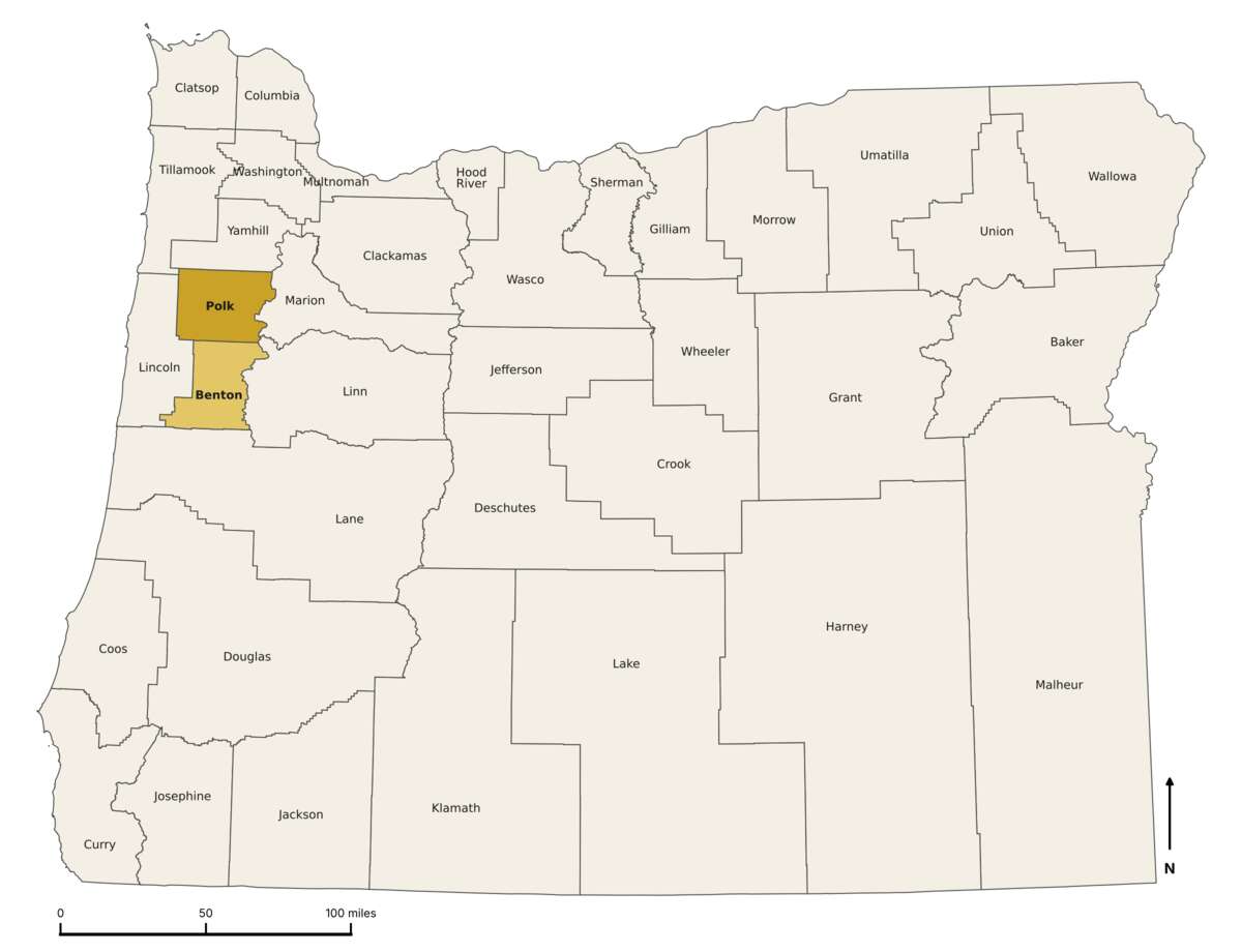
Figure 25.1. Oregon's 36 counties. Find your land, then your county: its clerk, assessor and surveyor keep the records for everything inside its lines. The tree farm near Pedee is in Polk County (dark), just north of Benton County (light), on the west side of the Willamette Valley. Drawn for this guide from U.S. Census Bureau county boundary files, 2023. Public domain.
Polk County, the tree farm's county
Website. polkcountyor.gov; the county's older address, co.polk.or.us, now forwards there. Clerk. Records land documents; Monday to Friday, 8 a.m. to noon and 1 to 5 p.m., with a 4:30 p.m. cutoff for recording and certified copies. The Digital Research Room searches recorded documents online (apps2.co.polk.or.us/DigitalResearchRoom; accept the disclaimer to enter). The State Archives' inventory lists the county's deed books from 1851 on microfilm at the clerk's office, indexes to deeds from 1856, a Historical Index of Land Deeds for 1854 to 1985 on the county website, and scans of deed volumes 75 to 110 (1920 to 1942) on FamilySearch. Assessor. Property Search Online (apps2.co.polk.or.us/PSO) covers more than 36,000 tax accounts; the county warns that its online applications "are not guaranteed to be accurate." Surveyor. Filed surveys, partition plats and corner records; reach the office through the county's main website. On the tree farm. The 1993 partition plat is county survey CS 12769, and the deeds from 1877 to 1989 are the farm's largest gap.14
Benton County, a second example
Assessor. Property Account Search and maps; 4500 SW Research Way, Corvallis, OR 97333; 541-766-6855; assessment.bentoncountyor.gov. Records. An online index to recorded deeds, mortgages and liens from 1966 to the present. "Online information is currently limited to index data," and document images come by request or in person. The deed index for 1848 to 1966 can be used only in person. Same address; 541-766-6756; Monday to Friday, 8 a.m. to 5 p.m.; re.bentoncountyor.gov. On the tree farm. None; the farm is in Polk County. Benton is here because it shows how differently two neighboring counties put their records online.
People, newspapers and burials
Historic Oregon Newspapers, University of Oregon
What it holds. More than 3.5 million pages of Oregon newspapers from 1846 to 2026, searchable by any word in them, with a list of titles and a map of places. Cost. Free. Website. oregonnews.uoregon.edu. On the tree farm. The Polk County Observer of May 26, 1905, reports a logger at Pedee "getting out 4,000,000 feet of logs on the Big Luckiamute."15
Chronicling America, Library of Congress
What it holds. The Library of Congress's national collection of digitized historic American newspapers. Cost. Free. Website. loc.gov/collections/chronicling-america. On the tree farm. Not yet searched for Pedee or the farm's families.
FamilySearch
What it holds. "Billions of ancestor profiles, photographs, and historical documents," with full-text search and a catalog. Filmed county deed books and Oregon's donation land claim files (National Archives microfilm M815) are reachable through it. Cost. Free, but you must "Create a free account" to see most images. It is run by The Church of Jesus Christ of Latter-day Saints. Website. familysearch.org. On the tree farm. Claim certificates 4751 and 4753 should hold the Tedrows' and John Johnson's sworn statements, and Polk County deed volumes 75 to 110, for 1920 to 1942, are scanned here.16
Find a Grave and Oregon's historic cemeteries
What they hold. Find a Grave lists "over 265 million memorials created by the community since 1995," searchable by name, dates and place; treat its volunteer records as leads, not proof. The Oregon Historic Cemeteries Program, in the Oregon Parks and Recreation Department, keeps a county-by-county list of historic cemeteries and guidance for their care. Polk County's volunteer-compiled pioneer cemetery records are at polkcountycemetery.org. Cost. Free. Websites. findagrave.com; oregon.gov/oprd/OH/pages/historic-cemeteries-program.aspx. On the tree farm. John and Phebe Johnson share a monument in Taylor Cemetery, about half a mile southwest of the Pedee store, and a Charles W. Pagett (1841 to 1905) is buried at Montgomery Cemetery.17
Tribal nations and archaeology
Confederated Tribes of Grand Ronde, Cultural Resources Department
What it does. Its Historic Preservation Office handles archaeology, research and cultural protection and reviews projects in the Tribe's ceded and ancestral homelands. Its Cultural Collections Program "provides access to archival materials and artifact collections," and the Chachalu Museum and Cultural Center "shares the Tribes' story." Where. Tribal headquarters, 9615 Grand Ronde Road, Grand Ronde, OR 97347; 800-422-0232 or 503-879-5211; info@grandronde.org. Chachalu is at 8720 Grand Ronde Road. Websites. grandronde.org; chachalu.org. On the tree farm. Grand Ronde lists the Luckiamute and Mary's River bands among the bands of the 1855 treaty that ceded the farm's township.18
Confederated Tribes of Siletz Indians, cultural program
What it does. Carries on the Tribe's history and language programs, with artifacts and historical documents kept at the Siletz Tribal Cultural Center. Agencies and others seeking "consultation; protected sites; site disturbances" write to CulturalResources@ctsi.nsn.us. Where. Siletz Tribal Community Center, 402 Government Hill Road, Siletz, OR 97380; main line 541-444-2532. Website. ctsi.nsn.us. On the tree farm. The Forest Service's record of the 1855 cession that includes the farm names the Siletz among the nations of today.19
Oregon State Historic Preservation Office
What it does. Oversees archaeology on land that is not federal: "An Oregon Archaeological Permit is needed to excavate or collect from an archaeological site" on public or private land. If you find an artifact: "Do not move or collect the artifact." Photograph it with a scale, and email the picture and its location to arch.permits@oprd.oregon.gov; 503-986-0690. For human remains, see Chapter 16. The office also keeps the Oregon Historic Sites Database, which lists surveyed buildings by address, at heritagedata.prd.state.or.us/historic. Website. oregon.gov/oprd/OH. On the tree farm. The farm's 2012 management plan records that no artifacts have been found on the property. If one ever is, this office is the first call.20
The author's own sources
Oregon Websites and Watersheds Project (ORWW)
What it is. "An educational, nonprofit 501 c(3) corporation founded in Philomath, Oregon in December 1996," offering "Online Tools for the Study and Stewardship of Oregon's Watershed Resources." It hosts Bob Zybach's Coquelle Trails and Tiller reports and the Kalapuya-Amin papers of 2006. Cost. Free. Website. orww.org. On the tree farm. The habits the farm's history follows come from the studies posted here (Chapter 4).
NW Maps Co.
What it is. The publisher of this guide, in Cottage Grove, Oregon. Its website carries Bob Zybach's books, his curriculum vitae, a page of free material and his 1999 Soap Creek Valley thesis. Website. nwmapsco.com. On the tree farm. The thesis lists 18 people of the "Luckymute Nation" by name from the Grand Ronde census rolls of 1860 and 1888 (Chapter 4).21
Before you go
Addresses, telephone numbers, hours and costs in this chapter were checked on October 10, 2026. Offices move, hours change and websites are rebuilt. If a web address fails, search for the name of the office or the collection, which lasts longer than the address, and call ahead before you drive to any office.
Notes
- A History of the Land (2026), "1871 to 1900: Railroad land and a seven-acre homestead," from Bureau of Land Management, General Land Office Records.
- A History of the Land (2026), annotated bibliography and "1871 to 1900."
- A History of the Land (2026), "Next steps for this property."
- Oregon State Archives, Oregon Historical County Records Guide, Polk County inventory, "Assessment and Tax Rolls," checked October 10, 2026.
- Oregon Historical Society Research Library, Mss 3100, John Johnson residence plans (1934), catalog entry, as read in A History of the Land (2026), annotated bibliography.
- A History of the Land (2026), "The twentieth century, seen from the air"; Oregon State University Libraries, Sanborn Fire Insurance Maps of Oregon, 1879-1956, collection guide, Archives West, checked October 10, 2026.
- Oregon State Archives, County Records Guide, Polk County inventory, checked October 10, 2026.
- Partition Plat No. 1993-0029, June 24, 1993, Polk County survey CS 12769.
- Oregon Department of Geology and Mineral Industries, Oregon Geologic Data Compilation and lidar (2011), as read for Chapter 13.
- Clarence A. Knezevich, Soil Survey of Polk County, Oregon (1982); NRCS Web Soil Survey.
- U.S. Geological Survey, topographic maps of the Pedee area, 1942 and 1974 with 1984 revisions, from topoView, as used in Chapter 11.
- NOAA National Centers for Environmental Information, Climate at a Glance, Polk County, Oregon, yearly precipitation from 1895.
- Partition Plat No. 1993-0029 (1993).
- Same; A History of the Land (2026), "Next steps for this property."
- Polk County Observer (Dallas, Oregon), May 26, 1905, in Historic Oregon Newspapers, University of Oregon.
- A History of the Land (2026), "Next steps for this property"; Oregon State Archives, County Records Guide, Polk County inventory, "Deed Records," checked October 10, 2026.
- Polk County Pioneer Cemeteries, Taylor and Montgomery cemetery records, as cited in A History of the Land (2026), "1855: Two claims and two houses" and "1871 to 1900."
- Confederated Tribes of Grand Ronde, "Treaties," grandronde.org; USDA Forest Service, Tribal Cession Lands, cession 352.
- USDA Forest Service, Tribal Cession Lands, cession 352.
- Sullivan Tree Farm Management Plan (2012), as quoted in A History of the Land (2026), "Before the surveyors."
- Bob Zybach, Using Oral Histories to Document Changing Forest Cover Patterns: Soap Creek Valley, Oregon, 1500-1999 (MAIS thesis, Oregon State University, 1999), Appendix D, Table D.1, pp. 250-251.