
Chapter 22. One tree farm from beginning to end
Thomas Hutchinson would not know the place. In 1855 he described prairie, oak and fir timber. In 1955 an aerial photograph shows open grass and scattered trees. Today the farm is almost entirely Douglas-fir plantation.1 This chapter follows the farm through every kind of evidence in order, as a model of a first pass, and ends with what is still unknown. Each step names the chapter where its method is taught.
The place and the questions
The Sullivan tree farm is about 211 acres of forest in Sections 28 and 33 of Township 9 South, Range 6 West, Willamette Meridian, in Polk County. It lies in the Coast Range foothills just west of Pedee. The west side drains to Pedee Creek and the east side straight to the Luckiamute River.2 Dave Sullivan bought it in December 1989. Two questions started the research in October 2026. Was the land really "homesteaded around the turn of the century," as its management plan said? And what was it like before it was a tree farm?3
What the records showed
The first pass took a few evenings, almost all of them spent with free records online. The table lists what each kind of record contributed, and the chapter of this guide that explains it.4
| Question | Where the answer came from | What it showed | Chapter |
|---|---|---|---|
| The rock | Oregon's geologic map, around Pedee | Mostly Tyee Formation sandstone, laid down on an ancient sea floor, with river deposits along the Luckiamute | 13 |
| The soil | The county soil survey, around Pedee | Jory and Peavine soils on the uplands; Waldo and Chehalis soils on the valley floor | 13 |
| The rain | NOAA's county records since 1895 | Polk County has averaged about 66 inches of precipitation a year | 14 |
| The river | U.S. Geological Survey stream gages | The largest flood on record came on December 22, 1964 | 14 |
| The first people | The 1855 treaty; tribal and published histories | Homeland of the Luckiamute, a Kalapuyan people, ceded by the treaty dated January 22, 1855 | 16 |
| The first survey | Daniel Murphy's field notes, March 1854 | Prairie, timber, and settlers' houses already standing | 6 |
| The claim surveys | Thomas H. Hutchinson's field notes, 1855 | Two donation land claims, each part rich prairie and part timber | 6, 7 |
| The corner trees | Both surveyors' field notes | Of 23 trees marked at corners on and near the farm, 15 were oaks and one was a Douglas-fir | 6, 15 |
| The first owners | Federal patents and the BLM historical index | Five patents, probably six: two claims, railroad grant land and one homestead | 7 |
| From the air | USDA photographs of 1936, 1955 and 1978 | Tree clumps and open ground, then open grass, then young plantation | 12 |
| The owner's files | The 2012 management plan and the 1993 survey | Grazing in earlier years, planting about 1976, logging in 1989, replanting in 1990 | 3, 18 |
The story in order
The ground
The farm sits on an old sea floor. Most of the upland around Pedee is Tyee Formation sandstone, laid down about 50 million years ago, with river deposits along the Luckiamute below it. Jory and Peavine soils cover the uplands (Chapter 13).5
The first people
The farm lies in the homeland of the Luckiamute, one of the Kalapuyan peoples of the Willamette Valley, who lived along the river and its creeks from about Rickreall south to Corvallis.6 Their leaders signed the treaty concluded at Dayton and dated January 22, 1855, by which the valley's bands ceded nearly the whole Willamette Valley. In the winter of 1855 to 1856 the bands were removed to Grand Ronde, and the Luckiamute arrived there in February or March 1856.7 Today the Confederated Tribes of Grand Ronde count the Luckiamute among the bands of that treaty. The farm's management plan records that no artifacts have been found on the property, and no record yet ties a named person to the farm itself.8 Chapter 16 tells this history at the scale of the river, where it belongs.
The surveyors and the two claims
In March 1854 deputy surveyor Daniel Murphy ran the section lines around what is now the farm (Chapter 6). He was not crossing empty country. From the section corner just east of the farm he wrote, "Mr Tedroe's dwelling bears S 51½° W," meaning: stand at the corner, face south, and turn 51½ degrees toward the west. Elsewhere he sighted the dwellings of Johnson and Taylor. Fifteen chains (990 feet; a chain is 66 feet) along the line between Sections 28 and 33, he wrote "Leave prairie & enter Timber."9
In the summer of 1855 deputy surveyor Thomas H. Hutchinson surveyed the settlers' donation land claims, the free grants made under the act of 1850, one by one: Mary Gilliam's on July 13 and 14, John W. Tedrow's on August 10 and 11, and John Johnson's on September 14 and 15.10 About 150 of the farm's acres lie in Claim No. 54, the 322 acres of John W. and Rachel Tedrow. About 12 more, on the east side, lie in Claim No. 53, the 323.5 acres of John Johnson. Of the Tedrow claim Hutchinson wrote, "There is but little improvement on the claim," and then, "but it is valuable on account of the timber on Luckiamute river and the rich prairie." Of Johnson's: "Three fourths of this claim is rich level prairie, one fourth is timbered. The claim is highly improved."11
The trees the surveyors marked at the corners tell the same story another way. Of the 23 bearing trees, the trees marked and measured so that a corner could be found again, that the two men recorded at 13 corners on and near the farm, 15 were oaks and only one was a "red fir," their name for Douglas-fir (Chapters 6 and 15).12
Two houses about 400 feet apart
Hutchinson tied both families' houses to one corner, the southwest corner of Johnson's claim, which lies inside today's farm. "Tedrow's house" stood S 40° E, 100 links (66 feet; a link is a hundredth of a chain) from it. "Johnson's house" stood N 40° E, about 6 chains (about 396 feet) from it. Work out the geometry and the two families lived only about 400 feet apart. Plotted from the notes, both houses fall inside what is now the tree farm. Murphy's two compass sightings on the Tedrow dwelling the year before, taken from two different points, agree within about 2 degrees.13
Nobody has yet walked the two sites with the notes in hand, and nothing has been found there. This guide gives the surveyor's bearings and distances, as the record does, and does not draw the sites on any map. Chapter 16 explains why.
The patents, and the story that needed correcting
The patents show that the farm left federal hands in five pieces, by five patents and probably a sixth, under three different laws (Chapter 7 and Figure 22.1).14
| Part of today's farm | First owner after the United States | Patent | Acres (about) |
|---|---|---|---|
| Most of the farm | John W. and Rachel Tedrow, donation land claim 54 | June 14, 1877 | 150 |
| The east side | John Johnson, donation land claim 53 | 1877 | 12 |
| The west side | Oregon and California Railroad, land grant | January 30, 1897, and November 29, 1899 | 31 |
| A small lot in the northeast | Oregon and California Railroad (probably) | July 12, 1871 | 7 |
| A strip along the north edge | Charles W. Pagett, homestead | October 12, 1900 | 7 |
The acreages are estimates from county map layers. They add up to about 207 acres, against the 211 the county assesses. Homesteading accounts for about 7 of them, and even Pagett was not the first to try: three earlier homestead entries on his tract, made in 1881, 1886 and 1887, were all cancelled, the last in October 1894.15 The error in the farm's story showed once the dates of the land laws were checked, and the lesson is general. Family stories, and even your own files, are leads to check.
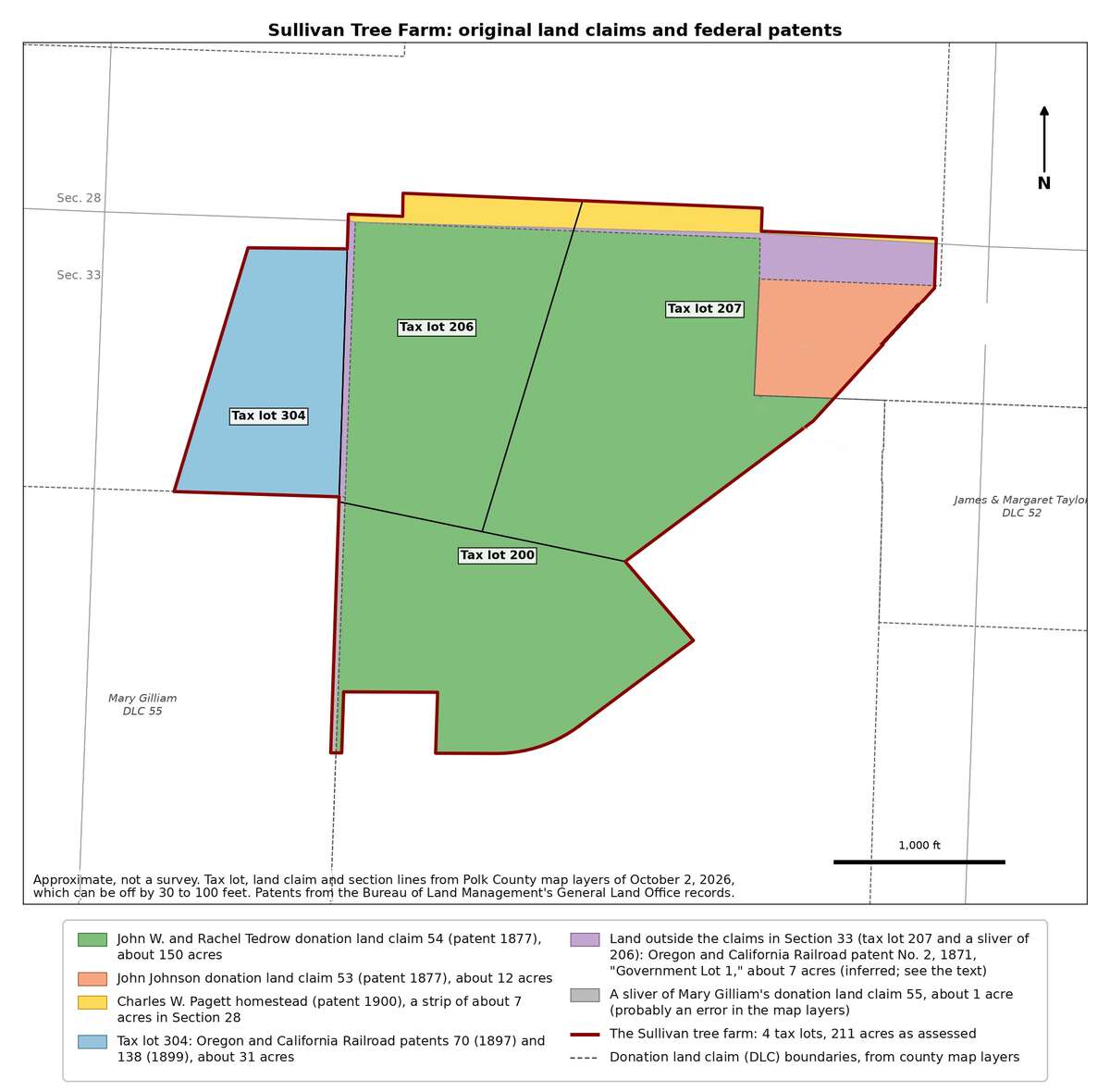
Figure 22.1. One farm, five ways out of federal ownership. Most of the farm was the Tedrow claim. The east side was Johnson's claim, the west side and, probably, the small northeast lot were railroad grant land, and the thin strip along the north edge is the only homestead land. The dashed lines are the old claim boundaries. Approximate, not a survey. Drawn for this guide from Polk County map layers (retrieved October 2, 2026) and Bureau of Land Management patent records.
From the air
The aerial photographs carry the story through the twentieth century (Chapter 12). The earliest, taken in 1936, covers about two-thirds of the farm: a patchwork of dark tree clumps and lighter open ground, with fields, orchards and the Valley and Siletz Railroad toward Pedee to the east. A dirt-floored dwelling of about the 1930s stood on the farm's east side; it had collapsed by 1990 and is now lost under blackberry.16
In 1955 the whole farm is in view (Figure 22.2): open grassland with scattered trees, crossed by tracks, with denser timber in the northeast and on the west side. The management plan says the property was fenced and grazed by cattle before its present owner's time, and the photograph fits. About 1976 Publishers Paper planted the open areas with Douglas-fir seedlings, each in a tube to keep the deer off, and the planting took. The 1978 photograph shows more trees, with pale open patches between them (Figure 22.3).17
Each outline on these photographs was fitted to the modern map by matching roads, and it fits only to within 100 to 250 feet. That is close enough to show what grew where. It is not close enough to find a corner or a tree.18
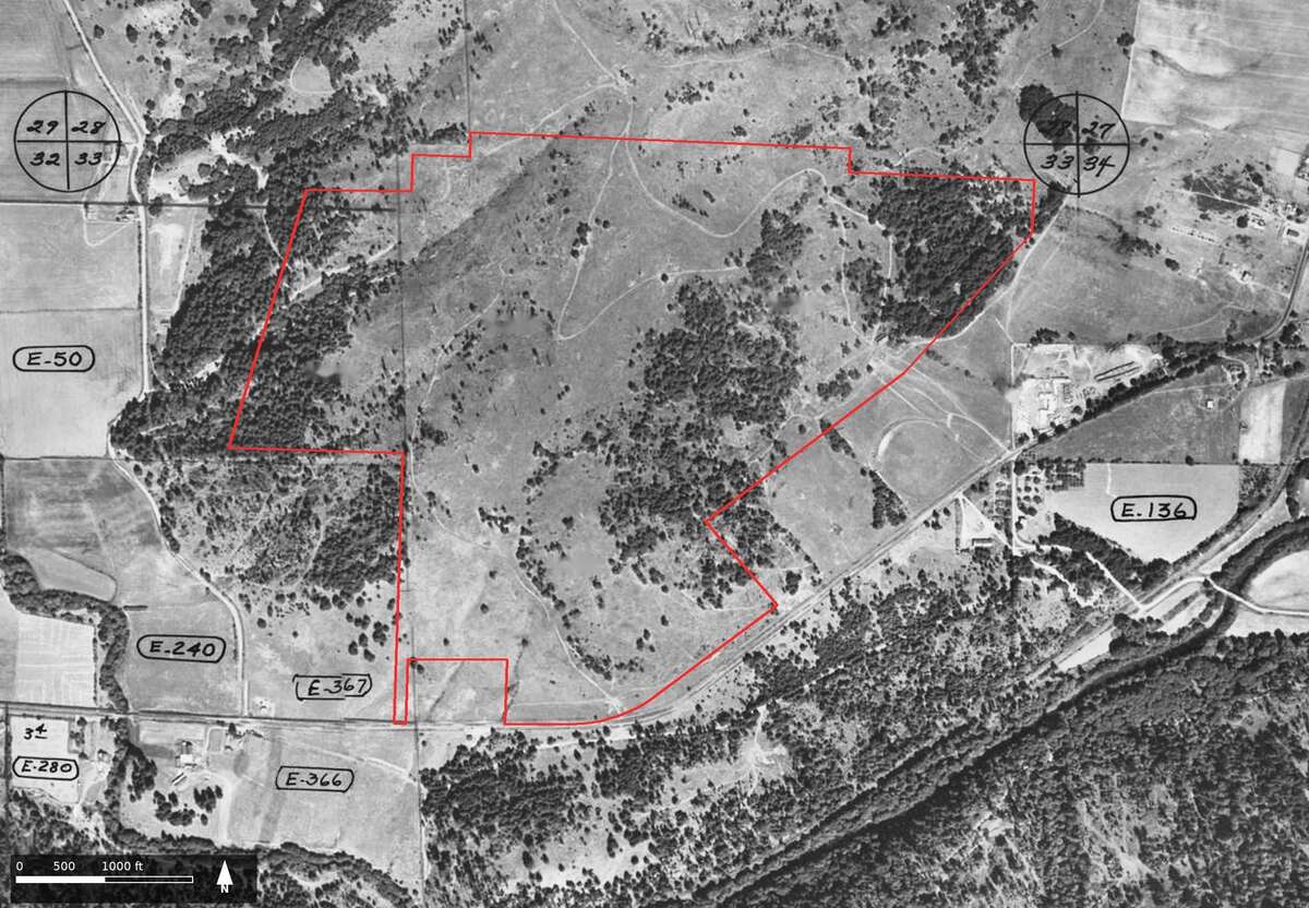
Figure 22.2. The farm in 1955. Look for the pale tracks crossing open grassland, the darker timber in the northeast and on the west side, and the two inked circles marking section corners. U.S. Department of Agriculture aerial photograph, Polk County, 1955. Oregon State University Libraries, through Oregon Digital. Outline approximate, fitted to within about 100 to 250 feet.
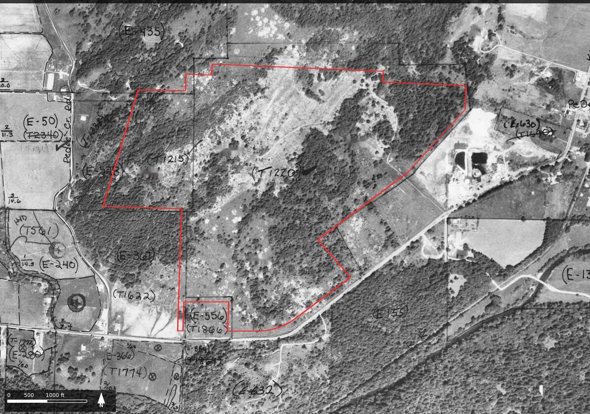
Figure 22.3. The farm in 1978. About two years after the planting of about 1976. Compare the tree cover with 1955. The inked labels, such as "T1215" and "T1220," are tract labels someone added to the print; they are part of the record, not this guide's. U.S. Department of Agriculture aerial photograph 41053-178-099-R, Polk County, 1978. Oregon State University Libraries, through Oregon Digital. Outline approximate.
Becoming a tree farm
In 1988 Publishers Paper sold the property to WTD Industries. WTD built a network of dirt roads and, in the spring of 1989, logged nearly all the merchantable timber, leaving about two-thirds of the land as bare dirt and brush piles. That December WTD sold the cutover, unplanted land to Dave Sullivan, for what his management plan calls "a bit over $300/acre."19
In 1990 he planted about 25,000 Douglas-fir seedlings himself and supervised students from Oregon State University's floor-hockey club, who planted about 25,000 more. Helicopters sprayed for grass control in 1990 and 1991, and he thinned the young trees on the 50 acres Publishers Paper had planted. In 1993 he had the main tract surveyed and divided into three parcels, by a survey that still finds its way by the 1855 claim corners (Chapter 3).20 Today conifer forest covers most of the farm (Figure 22.4).
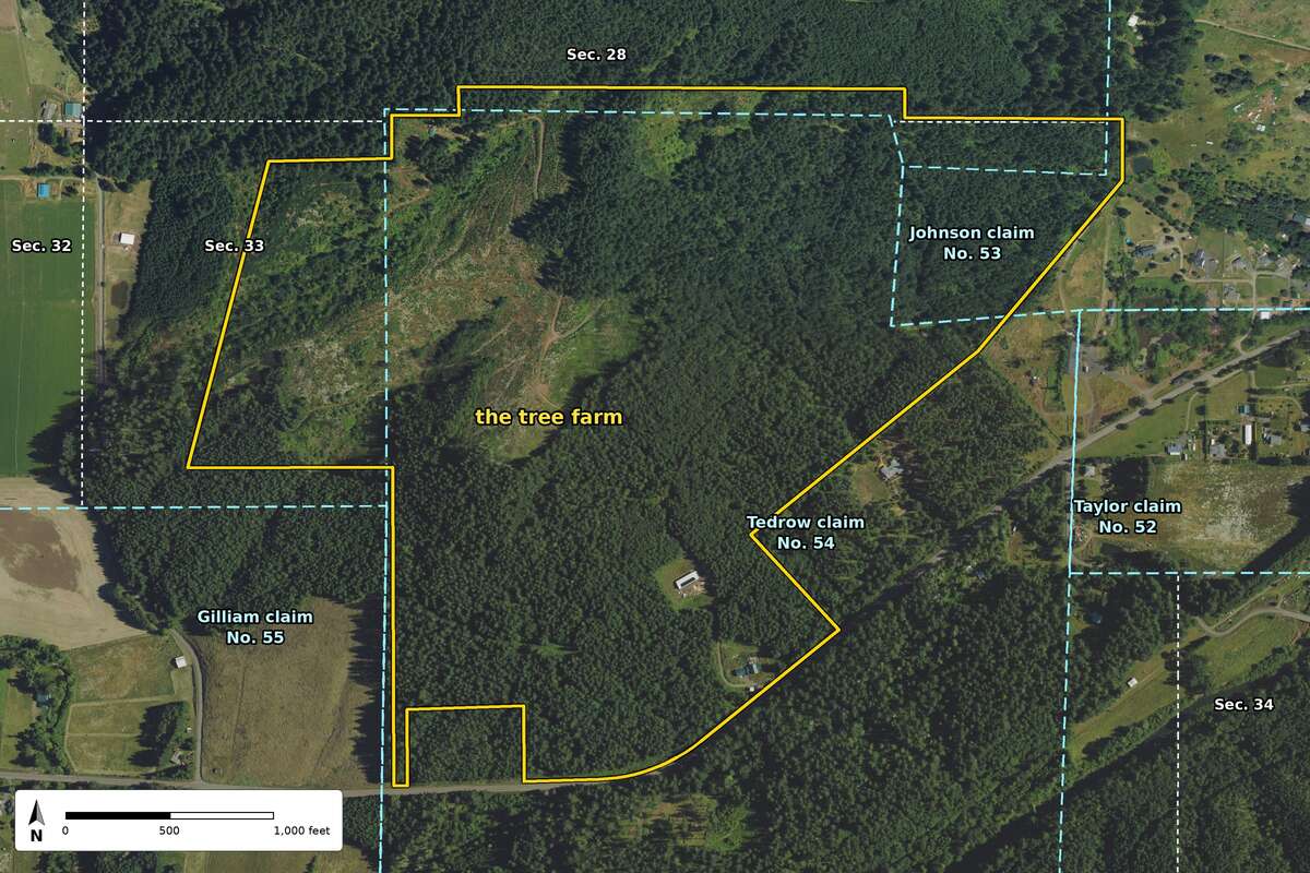
Figure 22.4. The farm today. Conifer forest covers most of the farm. The yellow line is the farm's outline. The blue dashed lines are the donation land claims Hutchinson surveyed in 1855, and the white dotted lines are section lines where they bound land outside the claims; both still shape the county's map. Compare the open ground of Figure 22.2. U.S. Department of Agriculture, National Agriculture Imagery Program, photographs of June 25 and July 11, 2022, through the U.S. Geological Survey's National Map. Public domain. Claim and section lines from Bureau of Land Management survey data. Outline approximate, not a survey.
A first timeline
The timeline puts the whole story in one list. Its gaps are as useful as its entries (Chapter 19).21
| Date | What happened | Source |
|---|---|---|
| Before 1856 | Homeland of the Luckiamute, a Kalapuyan people | Tribal and published histories |
| March 1854 | Section lines surveyed; prairie, timber and settlers' houses noted | Murphy's field notes |
| January 22, 1855 | Willamette Valley treaty concluded at Dayton | The treaty |
| May 1, 1855 | Township plat approved | The plat |
| August and September 1855 | Tedrow and Johnson claims surveyed | Hutchinson's field notes |
| Winter of 1855 to 1856 | The valley's bands removed to Grand Ronde | Published histories |
| July 12, 1871 | Railroad patent, probably covering the northeast lot | BLM historical index |
| 1877 | Patents for both claims, the Tedrows' on June 14 | BLM patent records |
| September 1881 | Railroad reaches Airlie | The Oregon Encyclopedia |
| 1881 to 1894 | Three homestead entries on Pagett's later tract, all cancelled | BLM historical index |
| 1897 and 1899 | Railroad grant patents for the west side | BLM patent records |
| October 12, 1900 | Homestead patent to Charles W. Pagett | BLM patent records |
| 1912 | Valley and Siletz Railroad incorporated | OSU history of Hoskins |
| 1934 | John Johnson house at Pedee drawn by the Historic American Buildings Survey | Oregon Historical Society catalog |
| 1936 | Earliest aerial photograph | USDA |
| 1955 | Aerial photograph shows open grassland and scattered trees | USDA |
| About 1976 | Open areas planted with Douglas-fir | Management plan |
| 1978 to 1979 | Valley and Siletz Railroad abandoned and taken up | OSU history of Hoskins and others |
| 1988 | Publishers Paper sells the land to WTD Industries | Management plan |
| Spring 1989 | Nearly all merchantable timber logged | Management plan |
| December 1989 | Dave Sullivan buys the land | Management plan |
| 1990 | About 50,000 seedlings planted | Management plan |
| June 24, 1993 | Main tract surveyed and divided | Partition plat |
What is still to do
The first pass ended with a list, and the list is the next chapter of the farm's history.22
- Trace the deeds from the patents to 1989 (Chapter 8). The 1993 survey cites a 1960 county survey and three easements by book and page to start from.
- Read the claimants' sworn statements in the donation land claim files, certificates 4751 and 4753 on National Archives microfilm M815, free on FamilySearch (Chapter 7). They should settle where the Tedrows married and confirm which John Johnson held Claim 53.
- Order Charles W. Pagett's homestead case file, final certificate 5919, from the National Archives, and copies of the unscanned railroad patents, among them the patent of 1871, from the Bureau of Land Management's public room (Chapters 7 and 25).
- Look for the estate files of John Johnson, who died in 1877, and Charles Pagett, who died in 1905 (Chapter 25).
- See the 1934 drawings of the John Johnson house at the Oregon Historical Society (Chapter 10).
- Find the farm on the forest maps of 1914 and the 1930s (Chapter 15).
- Record the owner's memories first, then those of earlier owners and neighbors (Chapter 18).
- Walk the old corners with the field notes in hand, and visit Taylor and Montgomery cemeteries (Chapter 17).
What the example shows
The first pass did not finish the history. It replaced a wrong story with a documented one, and it showed where the rest of the evidence is kept. That is what a first pass is for. A history that says plainly where its evidence stops is one that can be improved.
On the tree farm
Here is one record from the farm, read with care. In March 1854, 15 chains (990 feet) along the line between Sections 28 and 33, Daniel Murphy wrote "Leave prairie & enter Timber."23 Read it in four steps. What the record says: at a measured point on one section line, the surveyor passed from open prairie into timber, with settlers already living nearby. What it suggests: part of the farm that is forest today was open ground in 1854. What it does not say: how far the prairie reached on either side of the line, what kept it open, or when the trees filled in. What was checked next: the plat, the 1855 claim surveys, the trees marked at the corners and the aerial photographs, which is the order this chapter has followed.
Notes
- Hutchinson (1855), vol. D0022; USDA aerial photograph of Polk County, 1955, Oregon Digital; A History of the Land (2026), "December 1989 to today: becoming a tree farm."
- A History of the Land (2026), "The land today."
- Same, opening section; Sullivan Tree Farm Management Plan (2012).
- The rock: Oregon Department of Geology and Mineral Industries, Oregon Geologic Data Compilation; S. Taylor, B. Dutton and P. Poston, Field Guide to the Luckiamute River Watershed (2002). The soil: Clarence A. Knezevich, Soil Survey of Polk County, Oregon (1982), and the NRCS Web Soil Survey. The rain: NOAA, Climate at a Glance, Polk County series. The river: U.S. Geological Survey peak-flow records, stations 14190000 and 14190500. The first people: "Treaty with the Kalapuya, etc., 1855," 10 Stat. 1143. The rest: the records named in the notes that follow.
- Oregon Department of Geology and Mineral Industries, Oregon Geologic Data Compilation, unit descriptions for the country around Pedee; Taylor, Dutton and Poston (2002); Knezevich (1982).
- David G. Lewis, "Luckimauke Band of Calapooia Indians Reservation 1855," The Quartux Journal, May 15, 2016.
- "Treaty with the Kalapuya, etc., 1855," January 22, 1855, 10 Stat. 1143, in Charles J. Kappler, ed., Indian Affairs: Laws and Treaties, vol. 2; Melinda Jette, "Kalapuya Treaty of 1855," The Oregon Encyclopedia, updated March 17, 2022; Lewis (2016).
- Confederated Tribes of Grand Ronde, "Treaties," grandronde.org; Sullivan Tree Farm Management Plan (2012), as quoted in A History of the Land (2026), "Before the surveyors."
- Daniel Murphy, field notes of the section lines, T9S R6W, March 1854, BLM Oregon land records, vol. R0029, p. 331; A History of the Land (2026), "1852 to 1854: The surveyors arrive and find neighbors." Murphy wrote "prarie."
- Thomas H. Hutchinson, field notes of the donation land claim surveys, T9S R6W, 1855, BLM Oregon land records, vol. D0022; A History of the Land (2026), "1855: Two claims and two houses." The BLM index lists these surveys under 1856; the field notes are dated 1855 (Chapter 19).
- Hutchinson (1855), vol. D0022, p. 351 (Tedrow) and the closing page of the Johnson survey; A History of the Land (2026), "1855: Two claims and two houses."
- A History of the Land (2026), "The witness trees," a tally from Murphy (1854) and Hutchinson (1855).
- Hutchinson (1855), vol. D0022, pp. 347 and 363; Murphy (1854); A History of the Land (2026), "1855: Two claims and two houses."
- Bureau of Land Management, General Land Office Records, and the BLM historical index for T9S R6W, as tabulated in A History of the Land (2026), "1871 to 1900: Railroad land and a seven-acre homestead."
- Same.
- USDA aerial photograph of Polk County, 1936, Oregon Digital; A History of the Land (2026), "The twentieth century, seen from the air."
- USDA aerial photographs of Polk County, 1955 and 1978, Oregon Digital; Sullivan Tree Farm Management Plan (2012); A History of the Land (2026), "The twentieth century, seen from the air."
- A History of the Land (2026), "The twentieth century, seen from the air."
- Sullivan Tree Farm Management Plan (2012), as quoted in A History of the Land (2026), "December 1989 to today: becoming a tree farm."
- Same; Partition Plat No. 1993-0029, June 24, 1993, Polk County survey CS 12769.
- The records named in the table and in the notes above, with Richard Engeman, "Community of Airlie (Benton County)," The Oregon Encyclopedia (2022), for Airlie; Oregon State University Libraries, "Local History: Hoskins," and "Valley and Siletz Railroad," Wikipedia (both checked October 10, 2026), for the railroad; and Oregon Historical Society Research Library, Mss 3100, for the drawings of 1934.
- A History of the Land (2026), "Next steps for this property."
- Murphy (1854), vol. R0029, p. 331. Murphy wrote "prarie."