
Chapter 17. What you can see on the ground
In July 1855 Thomas Hutchinson marked the northeast corner of Mary Gilliam's land claim with two white oaks, 30 and 23 inches through. The corner lies on what is now the west line of the tree farm's main tract.1 In 1993 a surveyor dividing the main tract went looking for that corner. All he found was a fence corner, "there being no bearing tree evidence that I could accept." He set his marker on the line at the fence corner, but he would "not call it the DLC corner," the corner of the donation land claim.2
The ground is a record too. Much of what the old records describe can still be found on it, and some things on the ground appear in no record at all.
What to look for
- Old trees. A tree with wide, low limbs grew up in the open, even if it stands in a forest now (Figure 17.1). A line of old trees may mark a fence, a road or a property edge.
- Stumps. Their size, height and state of decay suggest when a stand was cut and how. A notch cut into an old stump held a springboard, the plank early loggers stood on to saw above the swell of the trunk (Figure 17.2). On a fresh stump you can count one ring for each year of growth.
- What grows where. Patches of plants that belong to open ground, to wet ground or to old gardens often outlast the conditions that brought them. Fruit trees, lilacs and daffodils in the woods usually mean a house stood nearby.
- Fence lines and corners. Old wire grown into trees, rock piles at field corners, and survey markers.
- Marks on trees. Blazes and old signs, such as the trail marker in Figure 17.3.
- Road and railroad grades. A level bench cut across a slope, often clear in lidar even where brush hides it (Chapter 13).
- Building sites. Foundation stones, a filled well, a level pad, bricks or glass.
- Water works. Ditches, ponds, spring boxes and the remains of dams.
- On a town lot. A change in the foundation or siding where a room was added, a hitching ring at the curb, a date stamped in the sidewalk.3
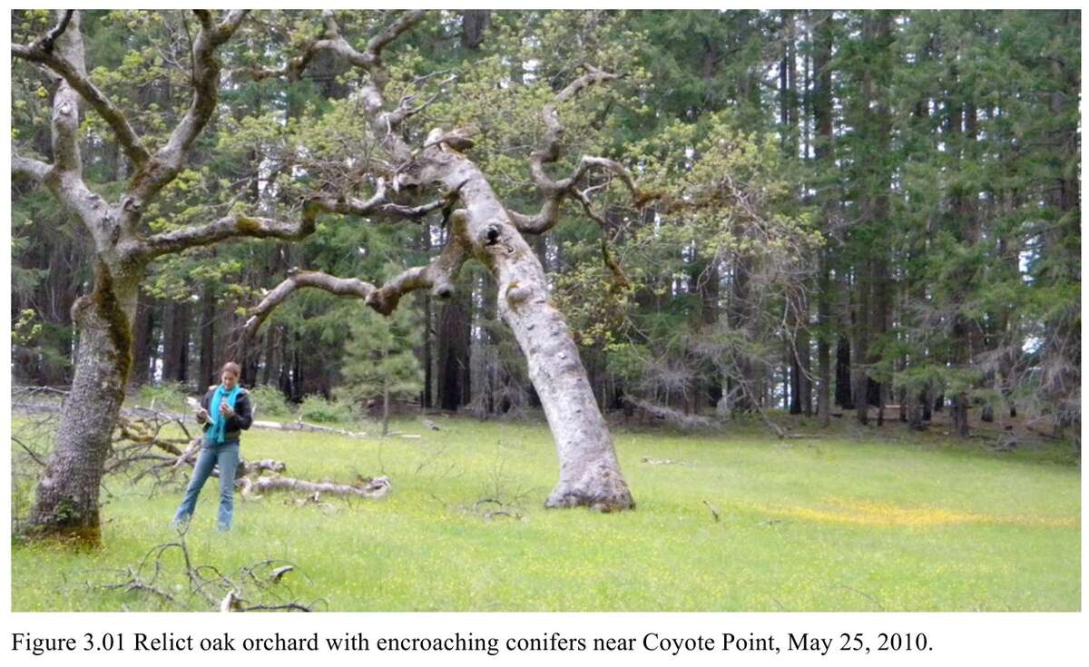
Figure 17.1. Old, wide-crowned oaks in a meadow near Coyote Point, in the South Umpqua headwaters, May 25, 2010. Notice the low, spreading limbs, the shape of a tree that grew up in the open, and the younger conifers closing in behind them. Bob Zybach, Tiller Pre-Contact Reference Condition Study (2011), Figure 3.01.
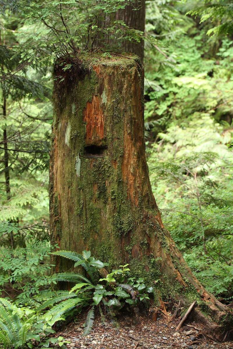
Figure 17.2. A springboard notch in an old stump, Lake Twenty-Two Trail, Washington. Loggers cut the notch, set a plank in it, and stood on the plank to saw above the swell of the trunk. A notch like this marks logging done by hand. Walter Siegmund, Wikimedia Commons. CC BY-SA 3.0.
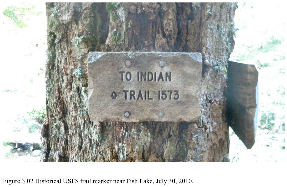
Figure 17.3. An old Forest Service trail marker on a tree near Fish Lake, in the South Umpqua headwaters, July 30, 2010. A mark on a tree can outlast the trail, the fence or the line it marked. Bob Zybach, Tiller Pre-Contact Reference Condition Study (2011), Figure 3.02.
How to record what you find
Photograph each thing in place, with something in the picture for scale. Record where it is, the date, and which way you were facing. Write down what you see first. Then, in a separate sentence, write down what you think it means, and at least one other thing it might mean.3 "A wide-crowned oak, about 30 inches through, standing among young firs" is an observation. "It grew up in open prairie" is one reading of it. "It grew up beside an old field" is another.
Leave it where it is
An object taken from the ground loses most of what it could tell anyone. If something may be very old, or may be a grave, stop and ask (Chapter 16).3
Predict, then look
The best use of a walk is to test what the records say. Mark on a map where the survey notes, old maps and aerial photographs say something should be: a corner, a trail, a house, the edge of a prairie. Then go and look. When the ground and the records agree, you can trust both more.3
Bob Zybach's study of the South Umpqua headwaters near Tiller, Oregon, worked this way. It moved through four overlapping steps: "archival research and literature review, predictive field map construction, 'ground-truthing' the predictive map (field research), and synthesis."4 From the records he marked where old ridgeline trails met and where camps and springs were named. On the ground, the evidence he expected "was readily found at each of these exact locations."5
What it costs
Walking your own land costs nothing but time. Walking anyone else's needs the owner's permission, every time.
On the tree farm
The next step on the farm is a walk with the survey notes in hand. Murphy and Hutchinson recorded 23 bearing trees at 13 corners on and near the farm, each with its kind, its diameter, and its compass bearing and distance from the corner.6 Most of those trees are surely long gone. The maps made for the farm's history plot them from the county's digital map, not from a survey, so they show where to look, not where an oak still stands.7 Several trees stood far from their corners, and one white oak stood 546 feet away.7 At that distance an error of 1 degree in the bearing moves the spot about 10 feet sideways, and an error of 5 degrees about 48 feet. So begin at an old corner that a modern survey has found and marked. The 1993 survey began at the county's brass cap at the northwest corner of the Tedrow claim.8 Look for a big stump, the hollow where one rotted away, or an old, wide-crowned oak among the firs, and photograph whatever you find where it lies. Two 1855 house sites also lie inside today's farm.9 Like any old house site, they are for looking and photographing, never for digging (Chapter 16).
Notes
- Thomas H. Hutchinson, field notes of the donation land claim surveys, T9S R6W, July 1855, BLM Oregon land records, vol. D0022, as read in A History of the Land (2026), "The witness trees"; the corner's place on the main tract's west line from Partition Plat No. 1993-0029, drawing (point 4).
- Partition Plat No. 1993-0029, June 24, 1993, narrative. Polk County survey CS 12769.
- Zybach, B., How to Research Your Land's History, review draft, October 7, 2026, "What you can see on the ground."
- Bob Zybach, Tiller Pre-Contact Reference Condition Study, final report, February 14, 2011 (Oregon Websites and Watersheds Project, for Resource Management Services, Roseburg, Oregon), p. 8.
- Same, p. 26.
- Daniel Murphy, field notes of the section lines, T9S R6W, March 1854, BLM Oregon land records, vol. R0029; Hutchinson (1855), vol. D0022; tally in A History of the Land (2026), "The witness trees."
- A History of the Land (2026), "The witness trees."
- Partition Plat No. 1993-0029, surveyor's certificate and drawing.
- Hutchinson (1855), vol. D0022, as read in A History of the Land (2026), "Two houses."