
Chapter 16. The first people on the land
On May 1, 1851, at Champoeg, three men spoke for the Luckiamute, the people of the river that runs past Pedee, and for their neighbors, the Marys River people. The two nations together were down to 44 men, women and children. Federal commissioners asked them to move east of the Cascade Mountains. Scho-la-que, also called "John," answered that they "did not wish to leave the country where they had always lived."1 Then he and the other two, Daboe, called "Jim," and Yuh-kow, signed an agreement to sell their land for $20,000. It took in most of Benton and Polk counties, and they were to keep a small reserve near present-day Airlie. The Senate never ratified the agreement, which means it never approved it, so it never took effect.2
People have lived in North America for many thousands of years, and on almost any piece of land the written record covers only the last small part of that time.3
The long human past
What it tells you. Archaeology is the study of people in the past through what they left behind: tools, hearths, house sites, trails, and the changes they made to the land. Regional studies can tell you how long people have lived in your area, how they lived, and what kinds of places they used.3
Where to find it. For Oregon, Oregon Archaeology, by C. Melvin Aikens, Thomas J. Connolly and Dennis L. Jenkins (Oregon State University Press, 2011), covers the whole state. The University of Oregon Museum of Natural and Cultural History is the state's official home for archaeological collections. The Oregon State Historic Preservation Office has plain-language guidance for landowners, including a short bulletin, Archaeological Sites on Private Lands.4
What you will not find. You will not find a public map of archaeological sites. Their locations are kept confidential, because sites that are published get looted. Each state's historic preservation office keeps the records, and Oregon's site records are open only to professional archaeologists and researchers who qualify.5 This guide follows the same rule. Research at the scale of a valley, a river or a township is right. Publishing the location of a site or a burial is not.
If you find something on your land
Leave it where it is. Oregon's preservation office asks you not to move or collect an artifact. Photograph it in place beside something for scale, such as a coin, a pen or a ruler, and send the picture and its location to the office's archaeologists at arch.permits@oprd.oregon.gov. In Oregon, a state permit is needed to dig or collect at an archaeological site on any land that is not federal, private land included.6 Keep the location private.
If you find what may be human remains, stop work and call the state police. Oregon law requires that remains thought to be Native be reported to the state police, the State Historic Preservation Officer, the appropriate tribe and the Commission on Indian Services.7 Other states have similar laws. This is general information, not legal advice.
The history the records keep
What it tells you. Who lived on the land before American settlement, how it passed out of their hands, and which nations are their descendants today. In the Willamette Valley much of that history is written down, and the records name people.
The Luckiamute were one of the Kalapuyan peoples of the Willamette Valley. They lived along the Luckiamute River and its creeks, from about Rickreall south to Corvallis.8 Their neighbors were the Marys River people, also called the Chapanafa, whose homeland took in present-day Corvallis. Sickness, probably malaria, struck the valley in 1831 and 1832 and killed a great many Kalapuyans. By 1841 only a few hundred were left in the whole valley.9
The treaty that took in most of the valley was made at Dayton in January 1855. Joel Palmer, the federal superintendent of Indian affairs, signed it for the United States. The Senate ratified it on March 3, 1855, and the President proclaimed it on April 10.10 In it the bands ceded, or gave up, nearly the whole Willamette Valley (Figure 16.1). The United States promised yearly payments for 20 years, starting at $10,000 a year, and the bands agreed to move to a permanent home to be chosen later.11 In the winter of 1855 to 1856 the valley's bands were forced to move to Grand Ronde. An order of President James Buchanan of June 30, 1857, made Grand Ronde a reservation.12
A law passed in 1954, the Western Oregon Indian Termination Act, ended the federal government's relationship with the Grand Ronde tribes in 1956. A law signed on November 22, 1983, restored it.13 The Confederated Tribes of Grand Ronde today list the Luckiamute and the Mary's River bands among the bands of the 1855 treaty.14 The federal record of the land ceded in 1855 names two more nations today, the Confederated Tribes of Siletz Indians and the Confederated Tribes of Warm Springs.15 The Coast Reservation of 1855, where the federal Siletz Agency stood, was meant in part for Willamette Valley peoples.16
Where to find it.
- The tribes themselves. Most tribes have a cultural resources office or a Tribal Historic Preservation Office. For the Luckiamute country, the Confederated Tribes of Grand Ronde keep their Cultural Resources Department and Historic Preservation Office at the Chachalu Museum and Cultural Center. The Confederated Tribes of Siletz Indians keep a cultural program at Siletz (Chapter 25). The national directory of tribal preservation offices is at nathpo.org. In Oregon, the Legislative Commission on Indian Services can tell you which tribes to contact for each part of the state.17
- Treaties. The texts are printed in Charles J. Kappler's Indian Affairs: Laws and Treaties and transcribed in the Tribal Treaties Database of Oklahoma State University. The signed original of the 1855 treaty is in the National Archives as Ratified Indian Treaty 282.18
- Cession maps. Charles C. Royce's Indian Land Cessions in the United States (1899) numbers each area given up by treaty. The Willamette Valley cession of 1855 is area 352 (Figure 16.1).19
- Histories by tribal scholars. For western Oregon, David G. Lewis's Tribal Histories of the Willamette Valley (2023) and his online Quartux Journal. The Oregon Encyclopedia adds short signed articles, among them Henry Zenk's "Kalapuyan Peoples," Melinda Jette's "Kalapuya Treaty of 1855" and Lewis's "Confederated Tribes of Grand Ronde."20
- Native voices in the record. In 1913 and 1914, William Hartless, a Marys River man born about 1844 where Corvallis now stands, dictated Marys River Kalapuya stories to the anthropologist Leo Frachtenberg. Melville Jacobs published them in Kalapuya Texts (1945).21
- Native Land Digital (native-land.ca), a map of traditional territories, which says plainly that it does not show official or legal boundaries.20
How to go about it. Find the treaty that covers your area and read it. Read at least one history written by, or with, the tribes concerned. Note what the early surveyors and travelers recorded about trails, camps and burned or open ground in your township (Chapter 6). If your questions go beyond the published sources, write to the tribe's cultural resources office and ask, and accept that some knowledge is not shared. Work at the scale of the valley, the river or the township. Never publish the location of a site or a burial. Treat each tribe as the authority on its own history.20
What it costs. Nothing but a library visit, or a letter or email to a tribe's cultural office.
A caution. A cession map shows lines that the United States drew, not where people lived. Councils, treaties and rolls were written down by government clerks, who spelled names as they heard them. Dabo of 1855 may be the Daboe of 1851, or he may not.22 Government records describe Native people from the outside, so read them beside the histories the tribes keep.
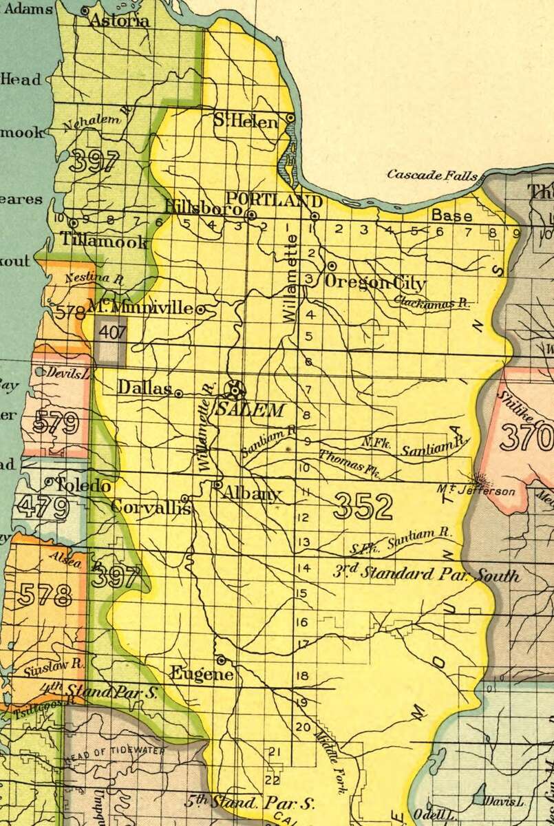
Figure 16.1. The Willamette Valley cession on an 1899 federal map. The yellow area numbered 352 is the land ceded in the treaty of January 22, 1855, from the Columbia River south past Eugene. The lines are the ones the United States drew, not where people lived. Charles C. Royce, Indian Land Cessions in the United States (1899), detail. Library of Congress. Public domain.
On the tree farm
The farm's own files said almost nothing about its first people. Its 2012 management plan says only that Native people "undoubtedly lived in the general area near the Luckiamute River" and that no artifacts have been found on the property.23 The records of the river say more. On January 4, 1855, three men signed the treaty for the "Cheluk-i-ma-uke band," which the historian David G. Lewis identifies as the Luckiamute: "Dabo, or Jim, first chief"; "Sco-la-quit, or John, second chief"; and "Yah-kow, or Kompetine, third chief."24 On March 14, 1855, two Polk County settlers agreed to let the band stay on about 25 acres of their land claims. Lewis places the 25 acres on the Luckiamute between Pedee and Monmouth, and he says the exact spot is his assumption.25 The Luckiamute reached Grand Ronde in February or March 1856, and a census there that year lists John as principal chief of a Luckiamute band of 22 people.25 The reservation rolls of 1860 and 1888 name 18 "Luckymute" people, among them Samanthy Wheeler, born about 1816; Peter Wheeler, called "Luckiamute Pete"; and James Durbin, called "Luckiamute Jim."26 No record found so far ties any of them to the farm itself. The Luckiamute are among the peoples of the Confederated Tribes of Grand Ronde, and that nation is the one to ask.27
Notes
- Bob Zybach, Using Oral Histories to Document Changing Forest Cover Patterns: Soap Creek Valley, Oregon, 1500-1999 (MAIS thesis, Oregon State University, 1999), pp. 137-138, quoting the council record as printed in Harold Mackey, The Kalapuyans: A Sourcebook on the Indians of the Willamette Valley (1974). The thesis names "the Chapanafa and Luckymute (or, Luckiamute)" nations at the council and reads the 44 as "the combined survivors of two nations." The newspaper count of that week gives the 44 as Luckiamute alone: the Oregon Spectator of May 8, 1851, "the Luckiamukes number forty-four," as quoted by David G. Lewis, "Luckimauke Band of Calapooia Indians Reservation 1855," The Quartux Journal, May 15, 2016.
- Zybach (1999), p. 137, and Map 13, p. 138; Melinda Jette, "Kalapuya Treaty of 1855," The Oregon Encyclopedia, Oregon Historical Society, updated March 17, 2022. The council record spells the third name Yuh-kow; the Spectator calls him Kone (Lewis 2016).
- Zybach, B., How to Research Your Land's History, review draft, October 7, 2026, "People before the written records" and "Archaeology and the long human past."
- Same; C. Melvin Aikens, Thomas J. Connolly and Dennis L. Jenkins, Oregon Archaeology (Oregon State University Press, 2011); Oregon State Historic Preservation Office, Archaeological Sites on Private Lands, Bulletin 1 (2019).
- Zybach, review draft, "Archaeology and the long human past"; Oregon State Historic Preservation Office, archaeology page, checked October 10, 2026.
- Oregon State Historic Preservation Office, archaeology page, checked October 10, 2026.
- Zybach, review draft, "Archaeology and the long human past"; Oregon Revised Statutes 97.745(4).
- Lewis (2016).
- Zybach (1999), pp. 30, 72 and 191, citing Robert Boyd (1990) on the epidemic and Charles Wilkes (1845) on the numbers.
- "Treaty with the Kalapuya, etc., 1855," January 22, 1855, 10 Stat. 1143, in Charles J. Kappler, ed., Indian Affairs: Laws and Treaties, vol. 2, as transcribed in the Tribal Treaties Database, Oklahoma State University Libraries.
- Same, articles 1 and 2; Jette (2022).
- Jette (2022); David Lewis, "Confederated Tribes of Grand Ronde," The Oregon Encyclopedia, updated November 13, 2023.
- Lewis, "Confederated Tribes of Grand Ronde" (2023).
- Confederated Tribes of Grand Ronde, "Treaties," grandronde.org, read October 8, 2026.
- USDA Forest Service, Tribal Cession Lands, cession 352 (after Royce 1899), retrieved October 8, 2026.
- Jette (2022); Lewis, "Confederated Tribes of Grand Ronde" (2023).
- Confederated Tribes of Grand Ronde, Cultural Resources page, and Confederated Tribes of Siletz Indians, Heritage page, both checked October 10, 2026; Oregon State Historic Preservation Office, archaeology page, checked October 10, 2026; Zybach, review draft, "Native peoples and their history on the land."
- Kappler, vol. 2; National Archives, Ratified Indian Treaty 282, National Archives Identifier 169820763.
- Charles C. Royce, Indian Land Cessions in the United States, in the Eighteenth Annual Report of the Bureau of American Ethnology, part 2 (1899).
- Zybach, review draft, "Native peoples and their history on the land."
- Zybach (1999), p. 30; Yvonne P. Hajda, Mary's River Kalapuyan: A Descriptive Phonology (MA thesis, Portland State University, 1976), p. 7; Henry Zenk, "The Kalapuyan Presence in Oregon's Geographic Names" (2006), note 6; Melville Jacobs, Kalapuya Texts (University of Washington Publications in Anthropology, vol. 11, 1945).
- Treaty of 1855 (Kappler, vol. 2); Zybach (1999), p. 137.
- Sullivan Tree Farm Management Plan (2012), as quoted in A History of the Land (2026), "Before the surveyors."
- Treaty of 1855 (Kappler, vol. 2), signatures of January 4, 1855; Lewis (2016).
- Lewis (2016), quoting the agreement of March 14, 1855, and the 1856 Grand Ronde census.
- Zybach (1999), Appendix D, Table D.1, pp. 250-251, compiled from Leonard Whitlow II, Grande Ronde Indian Reservation, Yamhill County, Oregon: 1860 Census, 1888 Census, 1901 Family Register (1988).
- Confederated Tribes of Grand Ronde, "Treaties," grandronde.org, read October 10, 2026: it lists the Luckiamute and Mary's River bands among the tribes and bands of the Willamette Valley Treaty of 1855.