
Chapter 21. All four kinds of evidence at once: the Oregon Coast Range
The rule fits in one line: "research questions are answered based on the 'weight of evidence' from multiple sources."1 Bob Zybach wrote it in 2003 about a whole mountain range. It works just as well for 211 acres.
The study it comes from, The Great Fires: Indian Burning and Catastrophic Forest Fire Patterns of the Oregon Coast Range, 1491-1951, asked how the burning done by Native people was related to the great forest fires of the Coast Range over 460 years. No single kind of record could answer that, so the study used all four kinds of evidence in this guide.
- Written documents. The journals of early travelers, and the notes of the land surveyors who followed them. The study warns that "all of the journalists were white males, so a certain amount of demographic bias needs to be taken into account for these narratives."2
- Images. Survey maps, early forest maps and aerial photographs. The government survey maps and notes locate trails, homesites, berry patches and fields of root and grain crops, mapping that, in the study's words, "cannot be duplicated by any other source of information."3
- The land itself. The patterns of forest, prairie and old burns.
- Living memory. Oral histories and interviews, including the interviews anthropologists made between 1910 and 1936 with members of the Siletz and Grand Ronde reservations.4
Every record in the study was tied to the same survey grid (Figure 21.1). Answers were chosen on the balance of the evidence, and the study expected them "to change or be modified as more information is made available."5
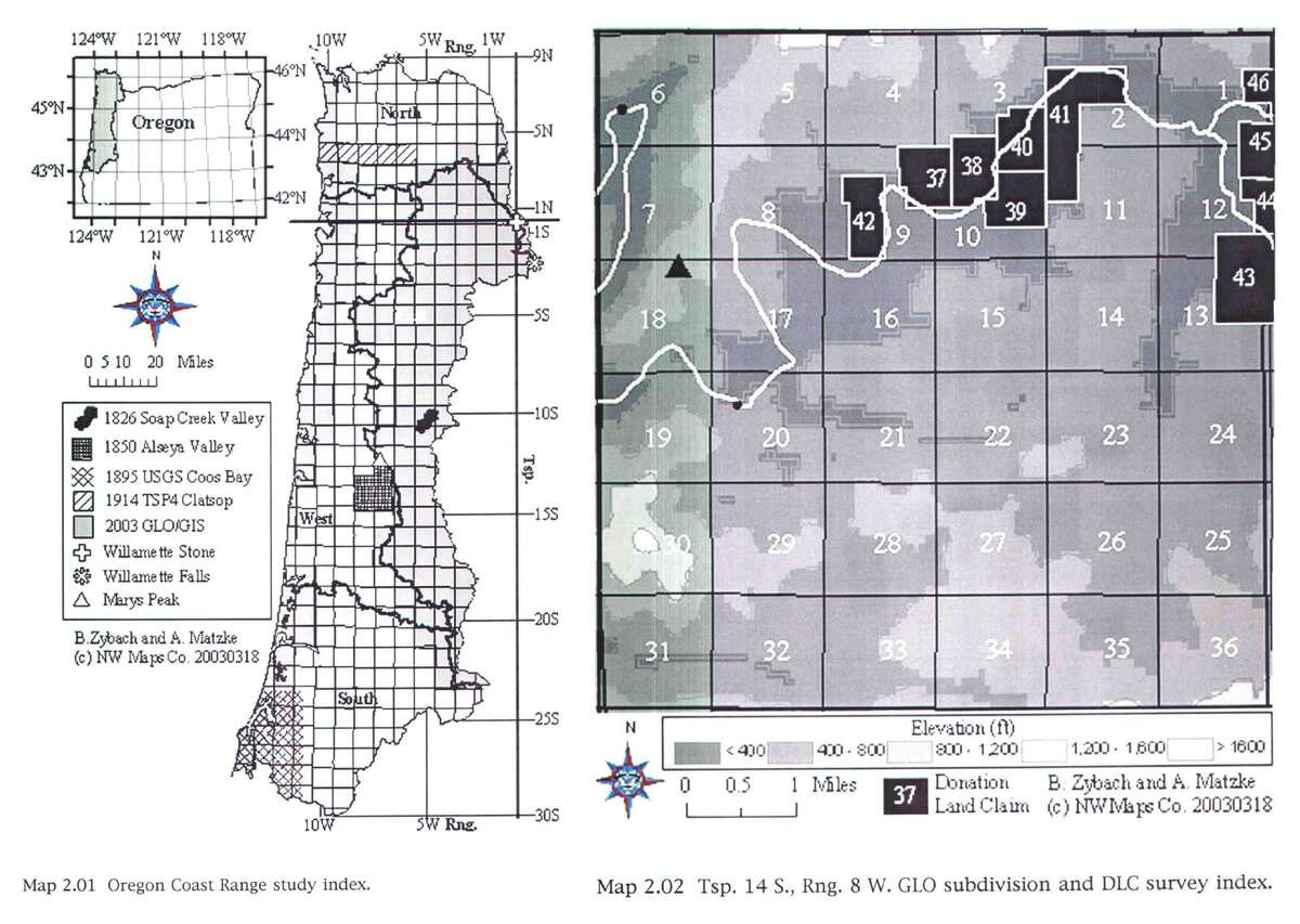
Figure 21.1. One grid for every record. On the left, the survey grid laid over the whole Oregon Coast Range, with the study's sample areas marked. On the right, one township, Township 14 South, Range 8 West, with its 36 sections and its numbered donation land claims. Journals, maps, photographs and memories were all placed on this grid before they were compared. Bob Zybach, The Great Fires (2003), Maps 2.01 and 2.02, maps by B. Zybach and A. Matzke, NW Maps Co.
Habit one: learn how each record was made
In the Alsea Valley, a line drawn around the valley's prairies on a General Land Office map of the early 1850s (the study's "1850 GLO Map") seemed to match a line drawn around the same prairies on a map of 1936. "However, the two were drawn in entirely different fashions." The 1936 line followed the innermost edge of the forest and the burns. The 1850 line followed the outermost edge of the grassland.6 Two lines in the same place meant two different things. Before you compare two records, find out how each one was made.
Habit two: say no more than the evidence supports
After weighing all four kinds of evidence across the range, the study found "a strong correlation between Indian burning practices in the Oregon Coast Range and subsequent Great Fire events; however, it has not demonstrated a cause and effect relationship between the two."7 That sentence is a model. It says what the evidence shows, and in the same breath it says what the evidence does not show.
On the tree farm
The farm's history weighs the same four kinds of evidence on 211 acres. The surveyors' notes of the 1850s, the aerial photograph of 1955 and the owner's management plan were made by different people, for different reasons, and none copied another. All three describe open ground where Douglas-fir plantation stands today.8 The history also follows habit two. It calls the surveyors' 23 corner trees, 15 of them oaks, a small sample chosen by surveyors, "not a survey of the vegetation," and it leaves open what kept the prairie open and when the trees closed in.9 Chapter 22 follows the farm through every kind of evidence in order.
Notes
- Bob Zybach, The Great Fires: Indian Burning and Catastrophic Forest Fire Patterns of the Oregon Coast Range, 1491-1951 (PhD dissertation, Oregon State University, 2003), p. 53.
- Zybach (2003), p. 77.
- Same, p. 96.
- Same, p. 83.
- Same, p. 53.
- Same, p. 122, and Map 2.14.
- Same, p. 296.
- Murphy (1854) and Hutchinson (1855); USDA aerial photograph of 1955, Oregon Digital; Sullivan Tree Farm Management Plan (2012); all as read in A History of the Land (2026), "The witness trees" and "The twentieth century, seen from the air."
- A History of the Land (2026), "The witness trees."