
The Sullivan tree farm near Pedee
Tax lots 9.6.33 lot 200, 9.6.33 lot 206, 9.6.33 lot 207 and 9.6.33 lot 304 · 211 acres by the county’s record · Polk County, Oregon
Township 9 South, Range 6 West, Willamette Meridian
The center of this land lies inside the outline of Donation Land Claim 54, which the patent record shows was granted to John W Tedrow and Rachel Tedrow on June 14, 1877, under the Oregon-Donation Act, covering 322 acres. Bearing-tree readings from the Hutchinson notes list 23 trees at 13 corners, mostly oaks. see the record
The 1855 township plat shows house squares labeled “Tedroe”, “Johnson”, “Taylor” and “A. Gage” on and near this land, and Hutchinson’s 1855 field notes name a road, “Roade to King’s Valley”, on this land. see the families
The sample report is Dave and Barb Sullivan’s own tree farm, at 12875 Kings Valley Highway in Polk County, Oregon. Researching its history is what gave them the idea for this site, so we use it as the example: in the software business that is called eating your own dog food.
Top 5 facts
- Soil map unit on the property: Peavine silty clay loam, 3 to 30 percent slopes (55D), about 4.9 acres, 71% of the land; well drained; hydrologic soil group C; land capability class 6; bedrock from about 30 inches; not prime farmland.1 USDA NRCS, Soil Survey Geographic Database via Soil Data Access (public domain), Sep 8, 2026. Open at the source
- Land patent to John Johnson, June 14, 1877, under Oregon-Donation Act (grant), 323.521 acres.2 Bureau of Land Management, General Land Office Records (public domain), Jun 14, 1877. Open at the source
- Field notes for the survey of Donation Land Claim 53: field-note book D0022, pages 363–367; Thomas H. Hutchinson; surveyed 1856 (BLM's index); approved February 20, 1859; original survey.3 Bureau of Land Management, Oregon/Washington land records (public domain), 1856. Open at the source
- Original township plat (cadastral survey), Township 9 South, Range 6 West, Willamette Meridian: dated May 1, 1855.4 Bureau of Land Management, Oregon/Washington land records (public domain), May 1, 1855. Open at the source
- Geologic map unit on the property: Tyee Formation (Tt), Eocene marine sedimentary rocks, about 100% of the land. Marine turbidite sandstone.5 Oregon Department of Geology and Mineral Industries, Oregon Geologic Data Compilation release 6 (OGDC-6), compiled by R. L. Smith and W. P. Roe. Open at the source

Contents
- Top facts
- Current information
- The last 50 years
- This land today
- Property tax
- Compare maps
- Water and weather
- Getting here
- 10 to 50 years ago
- Seen from above
- 50 to 100 years ago
- The families
- 100 to 200 years ago
- The surveyors arrive
- First owners
- More than 200 years ago (prehistory)
- The ground
- The people before the surveyors
- Timeline
- If you’re hooked
- Appendix: what we checked
Detail changes how much is shown. It never starts a new search. Written for: same facts, different words (Kids: to read with a child; Adults: plain English; Experts: full citations and the surveyors’ own terms).
Current information
The last 50 years
In your own report this part comes first, before everything else on the page: the tax account and map and tax lot, the values and taxes, the owner of record and the last sale, buildings by year, and recent aerial photographs, each with its source and the day we read it. The sample leaves them out: they belong to the people who live there.
This land today
211 acres by the county’s record; 206 acres measured from this outline.
Township 9 South, Range 6 West, Willamette Meridian · Polk County, Oregon
The record says: 1 record behind this part
Where this land sits on the survey grid
- In Township 9 South, Range 6 West, Willamette Meridian; touches Section 28, Section 33, Section 33, Donation Land Claim 53, Donation Land Claim 54. (our reading)6
Property tax
Tax values are shown only in your own private report, never on the sample.
How Oregon property tax works
Two values. Each year the assessor sets a real market value (RMV), roughly what the property would sell for on January 1, and a maximum assessed value (MAV). The tax is figured on the lower of the two, called the assessed value (AV). (Oregon Department of Revenue, Property tax: taxable value limitation)
Measure 50 (1997) and the 3% cap. Measure 50 set each property’s first MAV at 90% of its 1995–96 real market value and replaced most local levies with permanent tax rates. MAV may grow by no more than 3% a year, unless the property changes: new buildings or major improvements, a partition or subdivision, rezoning, or losing an exemption or special assessment. Because MAV follows a formula, two similar houses side by side can have very different assessed values and taxes. (Oregon Department of Revenue, Maximum Assessed Value Manual (150-303-438); ORS 308.146, maximum assessed value; Benton County Assessment, How Are Taxes Calculated?)
Measure 5 (1990) limits. The Oregon Constitution caps the taxes on each property at $5 per $1,000 of real market value for schools and $10 per $1,000 for general government. If a property’s taxes go over a limit they are reduced, or “compressed”, local option levies first. Most bond levies are outside these limits. Voters can approve short-term local option levies and bonds on top of the permanent rates. (Benton County Assessment, How Are Taxes Calculated?; Oregon Department of Revenue, Property tax: taxable value limitation)
Tax code areas. Each county assessor draws code areas every year, one for each combination of taxing districts (school district, city, fire district and so on) that overlap. Every property is in one code area, and all the property in a code area pays the same combined rate per $1,000 of assessed value. (ORS 310.147, code area system)
Your tax is, in short, the code area’s combined rate times the assessed value, less any Measure 5 compression and exemptions. (Benton County Assessment, How Are Taxes Calculated?)
Compare maps
Put any two maps side by side and drag the line between them: today’s air photo, older dated air photos, today’s topographic map, lidar of the bare ground, and the original survey plat, where they exist for this place. Where we have read the old records, old house sites and roads are marked on top, each with its evidence and source.
Open the map comparison
Loading the maps…
Water and weather
The weather record for the area is a county-wide average, not a reading taken on this land. In Polk County, yearly rain and snow averaged 66.9 inches in 1895–1924 and 67.5 inches in 1996–2025.7 The yearly average temperature in Polk County averaged 50.5 °F in 1895–1924 and 52.2 °F in 1996–2025.8 The county figures come from NOAA's county series, which covers 131 years, 1895 to 2025. The source notes that hills and valleys within the county differ, so the conditions on this land may not match these averages.9
Getting here
The nearest named places to this land are Pedee, a populated place about 0.6 miles away, and Pedee Creek, a stream about 0.9 miles away, both in Polk County.12 Grant Hill, a summit about 1.1 miles away, and McTimmonds Creek, a stream about 1.3 miles away, are also in the region around this land.13 The index also lists Maddux Reservoir (historical), about 1.6 miles away, which it marks as a historical hydrographic point, along with Link Creek, Ritner Creek and several other streams between about 1.8 and 2.1 miles away.14 These distances come from a gazetteer index and are only approximate; the index does not show that any of these features lies on this land, and the access routes to the land are not recorded in these sources.15
The record says: 19 records behind this part
Where the names of creeks, hills and roads came from
Beside this land
- Pedee (Populated Place), about 0.6 miles away.16
- Pedee Creek, a stream named in the national place-names list, near this land.17
- Grant Hill (Summit), about 1.1 miles away.18
- McTimmonds Creek, a stream named in the national place-names list, near this land.19
- Maddux Reservoir (historical) (Reservoir), about 1.6 miles away.20
- Link Creek, a stream named in the national place-names list, near this land.21
- Ritner Creek, a stream named in the national place-names list, near this land.22
- South Fork Pedee Creek, a stream named in the national place-names list, near this land.23
- North Fork Pedee Creek, a stream named in the national place-names list, near this land.24
- Kinsey Creek, a stream named in the national place-names list, near this land.25
- Clayton Creek, a stream named in the national place-names list, near this land.26
- McTimmonds Valley (Valley), about 2.2 miles away.27
- Morgan Reservoir (Reservoir), about 2.8 miles away.28
- Dry Creek, a stream named in the national place-names list, near this land.29
- Jahn Reservoir (Reservoir), about 4.1 miles away.30
- Tater Hill (Summit), about 5.7 miles away.31
- Glaze Creek, a stream named in the national place-names list, near this land.32
- Grant Creek, a stream named in the national place-names list, near this land.33
- Luckiamute River, a stream named in the national place-names list, near this land.34
10 to 50 years ago
Seen from above
The topographic map record for Township 9 South, Range 6 West, Willamette Meridian lists a series of USGS map editions that cover this property, beginning with a 1942 map of the Dallas, OR quadrangle at 1:62,500 scale.35 A 1953 Salem, OR map at 1:250,000 scale, followed by a 1954 edition of the same sheet, also covers the property according to the index.36 The Dallas, OR quadrangle at 1:62,500 scale appears again in 1957, and the Salem, OR 1:250,000 sheet is listed again for 1960, 1962 and 1963.37 A larger-scale map appears in the index for 1974: a Falls City, OR 1:24,000 quadrangle, which gives the most detailed view of the property among the listed editions.38 The last listed edition is a 1980 Corvallis, OR map at 1:100,000 scale. Across the whole series, the index records map editions only and does not describe the terrain shown on them.39
The record says: 9 records behind this part
The old topographic maps
- Topographic map covering the property: USGS 1:62500-scale Quadrangle for Dallas, OR 1942.40
- Topographic map covering the property: USGS 1:250000-scale Quadrangle for Salem, OR 1953.41
- Topographic map covering the property: USGS 1:250000-scale Quadrangle for Salem, OR 1954.42
- Topographic map covering the property: USGS 1:62500-scale Quadrangle for Dallas, OR 1957.43
- Topographic map covering the property: USGS 1:250000-scale Quadrangle for Salem, OR 1960.44
- Topographic map covering the property: USGS 1:250000-scale Quadrangle for Salem, OR 1962.45
- Topographic map covering the property: USGS 1:250000-scale Quadrangle for Salem, OR 1963.46
- Topographic map covering the property: USGS 1:24000-scale Quadrangle for Falls City, OR 1974.47
- Topographic map covering the property: USGS 1:100000-scale Quadrangle for Corvallis, OR 1980.48
What am I looking at? What air photos and topographic maps show
Air photos. Federal agencies have flown aerial photographs since 1937, first in black and white, later in color and color-infrared. Old photos show fields, orchards, clearcuts, roads, buildings and stream courses as they were; comparing years shows change. Scale and quality vary from flight to flight. (U.S. Geological Survey EROS, Aerial Photo Single Frames)
Topographic maps. The U.S. Geological Survey has published topographic maps since 1884. They show the height and shape of the land with contour lines, plus streams, roads, buildings, woodland, boundaries, mines and place names. Each edition is a snapshot of its year, so older editions show roads, schools and settlements that are gone. All editions from 1884 to 2006 are scanned and free; the current “US Topo” maps began in 2009. (U.S. Geological Survey, topoView help; U.S. Geological Survey, Historical Topographic Maps)
50 to 100 years ago
The families
Named on the old maps
The maps and survey notes read for the map comparison name these people and places. Each line says only what the record shows: a label on a plat, a line in the field notes. Whether any of them lived in a household here is not in these records.
- The 1855 township plat shows a house square labeled “Tedroe”; Hutchinson’s 1855 field notes call it “Tedrow’s house”, on John W. Tedrow’s Donation Land Claim 54. On this land. Placed to about 50 feet. From General Land Office township plat, T9S R6W, Willamette Meridian, approved May 1, 1855; Thomas H. Hutchinson, field notes, 1855, BLM Oregon volume D0022, page 347 (John W. Tedrow, Claim 54, north boundary). See it on the map comparison.
- The 1855 township plat shows a house square labeled “Johnson”; Hutchinson’s 1855 field notes call it “Johnson’s house”, on John Johnson’s Donation Land Claim 53. On this land. Placed to about 200 feet. From General Land Office township plat, T9S R6W, Willamette Meridian, approved May 1, 1855; Thomas H. Hutchinson, field notes, 1855, BLM Oregon volume D0022, page 363 (John Johnson, Claim 53, south boundary). See it on the map comparison.
- Hutchinson’s 1855 field notes name a road, “Roade to King’s Valley”, where it crossed the line between Mary Gilliam’s Donation Land Claim 55 and John W. Tedrow’s Donation Land Claim 54. On this land. Placed to about 100 feet. From Thomas H. Hutchinson, field notes of Donation Land Claim surveys, 1855, BLM Oregon volume D0022, page 345 (Mary Gilliam, Claim 55, east boundary). See it on the map comparison.
- The 1855 township plat draws a road across Section 33 from the southwest, between the Tedroe and Johnson house squares; the plat does not name it. On this land. Placed to about 600 feet. From General Land Office township plat, T9S R6W, Willamette Meridian, approved May 1, 1855. See it on the map comparison.
- The 1855 township plat draws a road north from the fork near the Johnson house square, through Section 28; the plat does not name it. Near this land, not shown to be on it. Placed to about 600 feet. From General Land Office township plat, T9S R6W, Willamette Meridian, approved May 1, 1855. See it on the map comparison.
- The 1855 township plat draws a road northeast from the same fork, across Section 34 into Section 27; the plat does not name it. Near this land, not shown to be on it. Placed to about 600 feet. From General Land Office township plat, T9S R6W, Willamette Meridian, approved May 1, 1855. See it on the map comparison.
- The 1855 township plat shows a house square labeled “Taylor”, on the Taylor Donation Land Claim 52, next to the Tedrow claim; the plat gives the surname only. Near this land, not shown to be on it. Placed to about 300 feet. From General Land Office township plat, T9S R6W, Willamette Meridian, approved May 1, 1855. See it on the map comparison.
- The 1855 township plat shows a house square labeled “A. Gage”, inside a hatched field on the line between Sections 28 and 29; the plat gives no more than the label. Near this land, not shown to be on it. Placed to about 400 feet. From General Land Office township plat, T9S R6W, Willamette Meridian, approved May 1, 1855. See it on the map comparison.
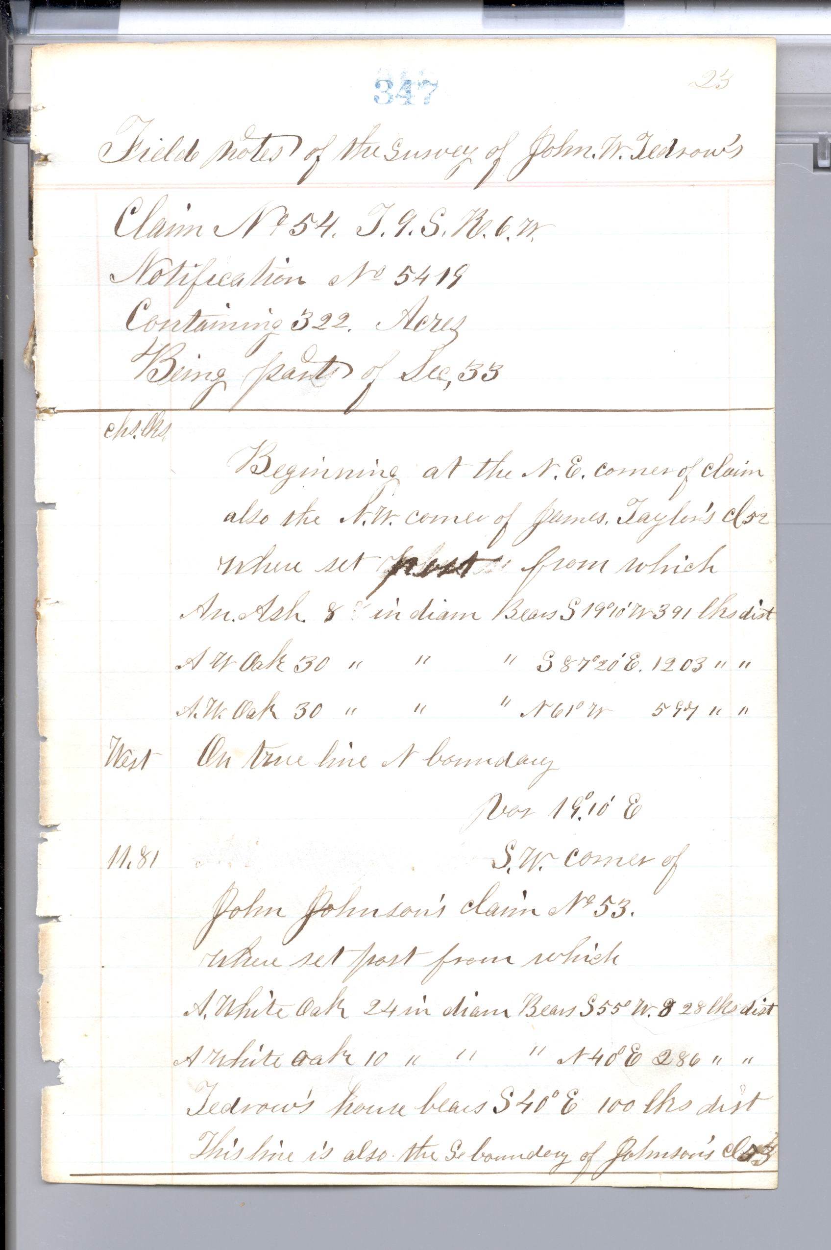
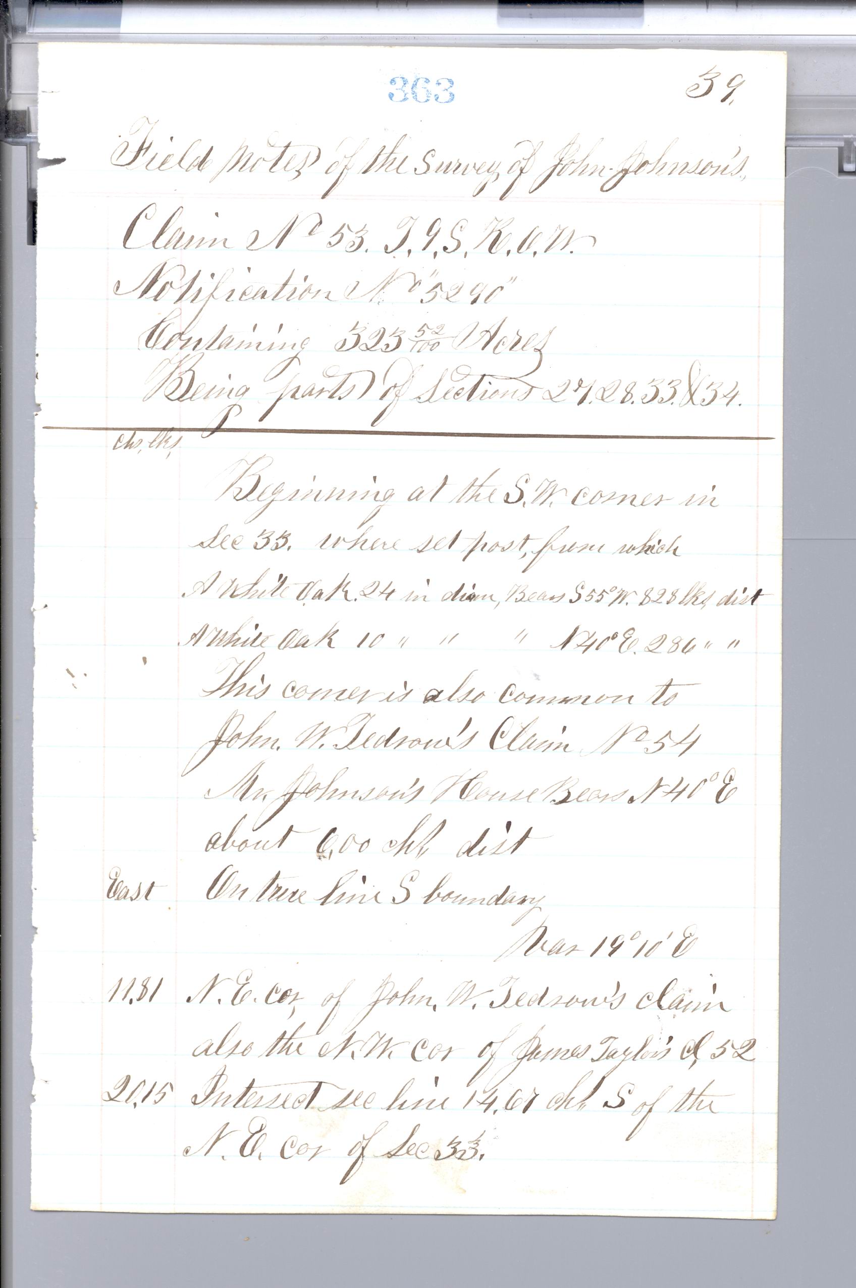
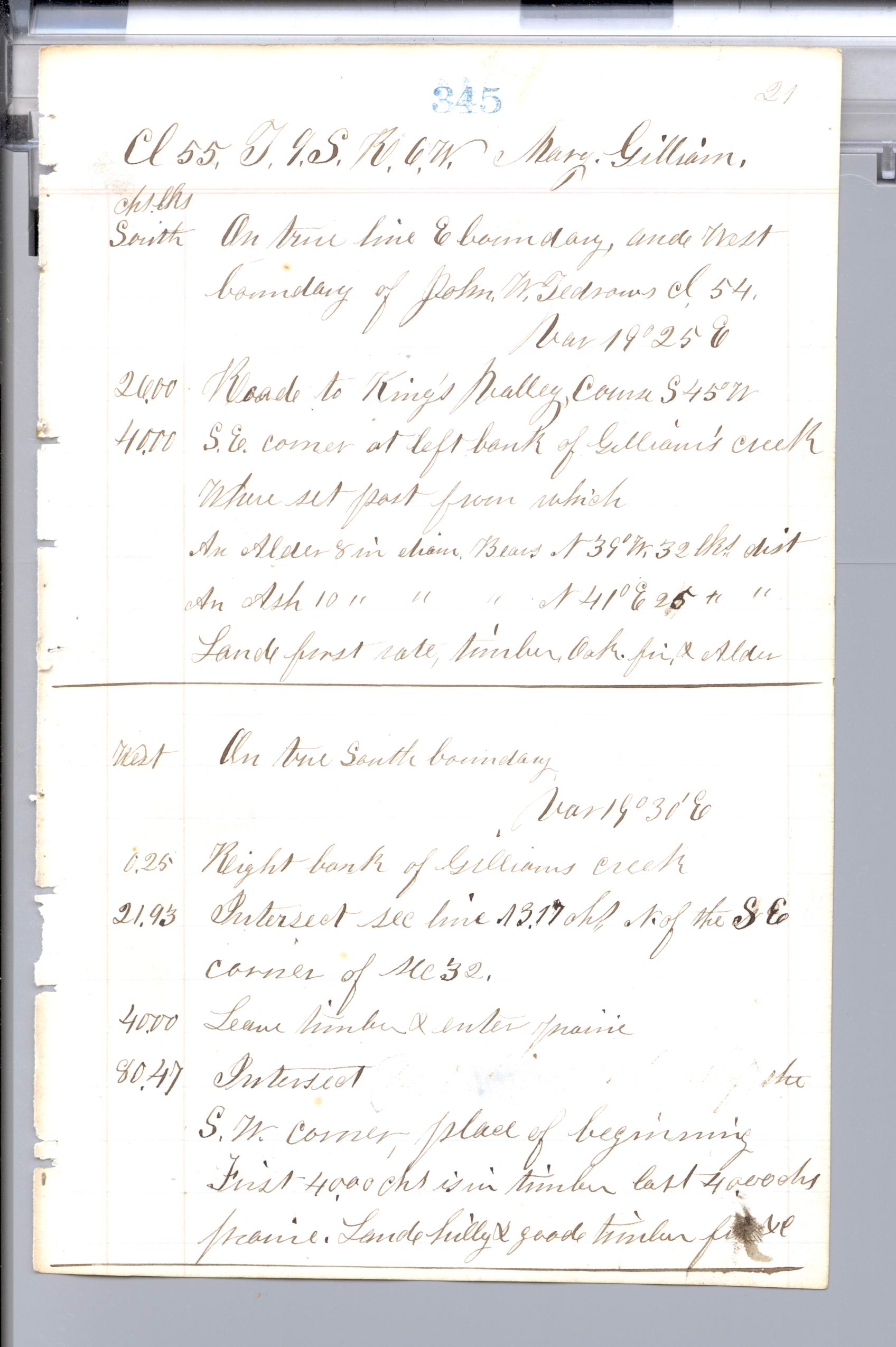
People named: John W. Tedrow (Donation Land Claim 54); John Johnson (Donation Land Claim 53); Mary Gilliam (Donation Land Claim 55); Taylor (Donation Land Claim 52), surname only, as the plat writes it; A. Gage, initial and surname only, as the plat writes it.
The record says: 1 record behind this part
Households in the census, through 1950
Around this valley
- Polk County had 62,380 people in 2000, 75,403 people in 2010 and 87,433 people in 2020 (U.S. Census).49
100 to 200 years ago
The surveyors arrive
The first township plat for Township 9 South, Range 6 West, Willamette Meridian is dated May 1, 1855, and the patent record shows it as an original cadastral survey.50 Fieldwork for the survey of Donation Land Claim 54 is dated by the notes to August 10–11, 1855, while BLM's index gives the year as 1856; the survey was approved February 20, 1859.51 Thomas H. Hutchinson is named as surveyor of Donation Land Claim 53 and Donation Land Claim 54, and the index dates that work to 1856 with approval on February 20, 1859.52 A plat dated February 11, 1861 shows Donation Land Claim 53 and Donation Land Claim 54 together, and the index identifies the claims as the first township plat approved on or after February 20, 1859.53 Subdivision field notes by Daniel Murphy, dated by the index to 1854 and approved April 18, 1855, are recorded as original survey work for this township.54 Bearing-tree readings from the Hutchinson notes list 23 trees at 13 corners, mostly oaks.55 Near this land, a bearing tree at the northwest corner of Donation Land Claim 54 is recorded as a white oak 20 inches in diameter.56

oak Douglas-fir other kinds the corner post. North is up in every panel. Each panel has its own scale: read the distance on its ring.
- Corner 1 3 trees
- Corner 2 2 trees
- Corner 3 2 trees
- Corner 4 2 trees
- Corner 5 no trees
- Corner 6 2 trees
- Corner 7 no trees
- Corner 8 3 trees
- Corner 9 2 trees
- Corner 10 2 trees
- Corner 11 1 tree
- Corner 12 2 trees
- Corner 13 2 trees
| Corner | Which corner | Kind | Diameter | Bearing | Distance | Surveyor, year | Field notes |
|---|---|---|---|---|---|---|---|
| Corner 1 | Northwest corner of Donation Land Claim 54 (John W. Tedrow), true northwest corner on north boundary | White oak | 20 inches | S 23° W | 23 links (15 feet) | Thomas H. Hutchinson, 1855 | OR D0022, page 348 |
| Corner 1 | Northwest corner of Donation Land Claim 54 (John W. Tedrow), true northwest corner on north boundary | White oak | 16 inches | S 41° E | 4 chains 5 links (267 feet) | Thomas H. Hutchinson, 1855 | OR D0022, page 348 |
| Corner 1 | Northwest corner of Donation Land Claim 54 (John W. Tedrow), true northwest corner on north boundary | White oak | 15 inches | N 62° E | 46 links (30 feet) | Thomas H. Hutchinson, 1855 | OR D0022, page 348 |
| Corner 2 | Northeast corner of Donation Land Claim 55 (Mary Gilliam), on west line of Donation Land Claim 54 | White oak | 30 inches | S 44° W | 2 chains 89 links (191 feet) | Thomas H. Hutchinson, 1855 | OR D0022, page 344 |
| Corner 2 | Northeast corner of Donation Land Claim 55 (Mary Gilliam), on west line of Donation Land Claim 54 | White oak | 23 inches | N 81½° W | 2 chains 24 links (148 feet) | Thomas H. Hutchinson, 1855 | OR D0022, page 344 |
| Corner 3 | Donation Land Claim 54 "N.E. corner on N side of claim", on section line 19.68 chains (1,299 feet) east of quarter-section post between Sections 28 and 33 | Douglas-fir (written as red fir) | 12 inches | S 18° W | 22 links (15 feet) | Thomas H. Hutchinson, 1855 | OR D0022, page 348 |
| Corner 3 | Donation Land Claim 54 "N.E. corner on N side of claim", on section line 19.68 chains (1,299 feet) east of quarter-section post between Sections 28 and 33 | Cherry | 5 inches | S 20° E | 16 links (11 feet) | Thomas H. Hutchinson, 1855 | OR D0022, page 348 |
| Corner 4 | Northwest corner on west side of the "El" of Donation Land Claim 53 (John Johnson), north boundary of the El | White oak | 8 inches | S 3° W | 1 chain 22 links (81 feet) | Thomas H. Hutchinson, 1855 | OR D0022, page 366 |
| Corner 4 | Northwest corner on west side of the "El" of Donation Land Claim 53 (John Johnson), north boundary of the El | White oak | 24 inches | S 41½° E | 9 chains 42 links (622 feet) | Thomas H. Hutchinson, 1855 | OR D0022, page 366 |
| Corner 6 | Quarter-section corner between Sections 28 and 33 (true line between Sections 28 and 33) | Oak | 10 inches | N 55½° W | 1 chain 65 links (109 feet) | Daniel Murphy, 1854 | OR R0029, page 331 |
| Corner 6 | Quarter-section corner between Sections 28 and 33 (true line between Sections 28 and 33) | Oak | 24 inches | S 35° W | 3 chains 39 links (224 feet) | Daniel Murphy, 1854 | OR R0029, page 331 |
| Corner 8 | Northeast corner of Donation Land Claim 54 (John W. Tedrow), also the northwest corner of Donation Land Claim 52 (James Taylor) | Ash | 8 inches | S 19°10' W | 3 chains 91 links (258 feet) | Thomas H. Hutchinson, 1855 | OR D0022, page 347 |
| Corner 8 | Northeast corner of Donation Land Claim 54 (John W. Tedrow), also the northwest corner of Donation Land Claim 52 (James Taylor) | White oak | 30 inches | S 87°20' E | 12 chains 3 links (794 feet) | Thomas H. Hutchinson, 1855 | OR D0022, page 347 |
| Corner 8 | Northeast corner of Donation Land Claim 54 (John W. Tedrow), also the northwest corner of Donation Land Claim 52 (James Taylor) | White oak | 30 inches | N 61° W | 5 chains 97 links (394 feet) | Thomas H. Hutchinson, 1855 | OR D0022, page 347 |
| Corner 9 | Southwest corner of Donation Land Claim 53 (John Johnson), on north boundary of Donation Land Claim 54 | White oak | 24 inches | S 55° W | 8 chains 28 links (546 feet) | Thomas H. Hutchinson, 1855 | OR D0022, page 347 |
| Corner 9 | Southwest corner of Donation Land Claim 53 (John Johnson), on north boundary of Donation Land Claim 54 | White oak | 10 inches | N 40° E | 2 chains 86 links (189 feet) | Thomas H. Hutchinson, 1855 | OR D0022, page 347 |
| Corner 10 | Corner of Sections 28, 29, 32 and 33 | Oak | 24 inches | S 10° E | 4 chains 48 links (296 feet) | Daniel Murphy, 1854 | OR R0029, page 330 |
| Corner 10 | Corner of Sections 28, 29, 32 and 33 | Oak | 8 inches | N 56° E | 2 chains 66 links (176 feet) | Daniel Murphy, 1854 | OR R0029, page 330 |
| Corner 11 | Quarter-section corner between Sections 32 and 33 (in Mrs Gilliam's door yard) | Alder | 6 inches | S 88° W | 1 chain 56 links (103 feet) | Daniel Murphy, 1854 | OR R0029, page 330 |
| Corner 12 | Quarter-section corner between Sections 33 and 34 | Cherry | 6 inches | S 24° W | 63 links (42 feet) | Daniel Murphy, 1854 | OR R0029, page 318 |
| Corner 12 | Quarter-section corner between Sections 33 and 34 | Willow | 7 inches | S 65° E | 26 links (17 feet) | Daniel Murphy, 1854 | OR R0029, page 318 |
| Corner 13 | Southeast corner of Donation Land Claim 55 (Mary Gilliam), at left bank of Gilliam's creek, on west line of Donation Land Claim 54 | Alder | 8 inches | N 39° W | 32 links (21 feet) | Thomas H. Hutchinson, 1855 | OR D0022, page 345 |
| Corner 13 | Southeast corner of Donation Land Claim 55 (Mary Gilliam), at left bank of Gilliam's creek, on west line of Donation Land Claim 54 | Ash | 10 inches | N 41° E | 25 links (17 feet) | Thomas H. Hutchinson, 1855 | OR D0022, page 345 |
- Corner 5 Northwest corner of Donation Land Claim 53 (John Johnson), on west side of claim, 59.59 chains (3,933 feet) south on west boundary. rock 12 in long & 4 thick, post, trench, mound
- Corner 7 Corner of Sections 27, 28, 33 and 34. post, charred stake, mound, trench
Typed copies of the field notes
The original field notes are handwritten. Where a county surveyor or a library has typed them up and put them online, we link the typed copy here, next to the scans. We opened Polk County’s survey-records pages on October 22, 2026: they hold filed surveys and corner records and point to the Bureau of Land Management scans, but no typed copy of the original field notes.
- The notes drawn on maps. Oregon Tech Library, GLO Survey Notes Mapping. The field notes hand-transcribed onto U.S. Geological Survey 7.5-minute quadrangle maps for Oregon. Maps, not text. Find the quadrangle that holds your land. Link checked October 22, 2026.
- Scans. Bureau of Land Management Oregon/Washington, cadastral survey records. Image scans of the field-note books for every township in Oregon and Washington: the handwritten originals, with some later surveys typed. No text search. By township and range. Link checked October 22, 2026.
- Scans. Bureau of Land Management, General Land Office Records. Image scans of the township plats and, for many states, the field notes. By legal land description. Link checked October 22, 2026.
Paper copies of the field notes also sit in some county surveyors’ offices; the Oregon State Archives’ county records inventories list them (for example, Lane County’s volumes A to R). Those are not online. From Chaney’s source check of October 22, 2026; send a missing county’s link to hello@yourlandhistory.org.
The record says: 48 records behind this part
The first survey map
- Original township plat (cadastral survey), Township 9 South, Range 6 West, Willamette Meridian: dated May 1, 1855.57
- Township plat (cadastral survey), Township 9 South, Range 6 West, Willamette Meridian: dated September 28, 1857.58
- Plat showing Donation Land Claim 53 and Donation Land Claim 54 (cadastral survey), Township 9 South, Range 6 West, Willamette Meridian: dated February 11, 1861.59
- Township plat (cadastral survey), Township 9 South, Range 6 West, Willamette Meridian: dated January 6, 1896.60
- Township plat (cadastral survey), Township 9 South, Range 6 West, Willamette Meridian: dated September 9, 1935.61
- Township plat (cadastral survey), Township 9 South, Range 6 West, Willamette Meridian: dated November 22, 1976.62
- Township plat (cadastral survey), Township 9 South, Range 6 West, Willamette Meridian: dated July 9, 1982.63
- Township plat (cadastral survey), Township 9 South, Range 6 West, Willamette Meridian: dated March 14, 2023.64
Beside this land
- Plat of the township's outer lines (exterior plat), Township 9 South, Range 6 West, Willamette Meridian: dated June 15, 1854.65
What the first surveyors wrote about this ground
- Field notes for the survey of Donation Land Claim 53: field-note book D0022, pages 363–367; Thomas H. Hutchinson; surveyed 1856 (BLM's index); approved February 20, 1859; original survey.66
- Field notes for the survey of Donation Land Claim 54: field-note book D0022, pages 347–351; Thomas H. Hutchinson; the notes date the fieldwork to August 10–11, 1855 (page 351); BLM's index gives the year as 1856; approved February 20, 1859; original survey.67
- Subdivision field notes, Township 9 South, Range 6 West, Willamette Meridian: field-note book R0029, pages 279–340; Daniel Murphy; surveyed 1854 (BLM's index); original survey.68
- Subdivision field notes, Township 9 South, Range 6 West, Willamette Meridian: field-note book R0029, pages 281–339; Daniel Murphy; surveyed 1855 (BLM's index); approved April 18, 1855; original survey.69
- Subdivision field notes, Township 9 South, Range 6 West, Willamette Meridian: field-note book R0052, pages 591–594; A Smith; surveyed 1856 (BLM's index); approved September 28, 1857; original survey.70
- Subdivision field notes, Township 9 South, Range 6 West, Willamette Meridian: field-note book D0022, page 338; T Hutchinson; surveyed 1855 (BLM's index); approved February 20, 1859; resurvey.71
- Subdivision field notes, Township 9 South, Range 6 West, Willamette Meridian: field-note book R0596, pages 261–279; Bureau of Land Management resurvey, 1973; approved November 22, 1976.72
- Subdivision field notes, Township 9 South, Range 6 West, Willamette Meridian: field-note book R0616, pages 170–174; Tuers; surveyed 1979 (BLM's index); approved July 9, 1982; original survey.73
- Subdivision field notes, Township 9 South, Range 6 West, Willamette Meridian: field-note book R0703, pages 217–219; Bureau of Land Management resurvey, 2020; approved March 14, 2023.74
Beside this land
- North boundary field notes, Township 9 South, Range 6 West, Willamette Meridian: field-note book R0017, pages 353–354; Butler Ives; surveyed 1852 (BLM's index); original survey.75
- South boundary field notes, Township 9 South, Range 6 West, Willamette Meridian: field-note book R0017, pages 369–370; Butler Ives; surveyed 1852 (BLM's index); original survey.76
- East boundary field notes, Township 9 South, Range 6 West, Willamette Meridian: field-note book R0017, pages 353–354; Butler Ives; surveyed 1852 (BLM's index); original survey.77
- East boundary field notes, Township 9 South, Range 6 West, Willamette Meridian: field-note book R0017, pages 363–370; Butler Ives; surveyed 1852 (BLM's index); original survey.78
- North boundary field notes, Township 9 South, Range 6 West, Willamette Meridian: field-note book R0029, pages 31–38; Daniel Murphy; surveyed 1853 (BLM's index); original survey.79
- South boundary field notes, Township 9 South, Range 6 West, Willamette Meridian: field-note book R0029, pages 43–49; Daniel Murphy; surveyed 1853 (BLM's index); original survey.80
- East boundary field notes, Township 9 South, Range 6 West, Willamette Meridian: field-note book R0020, pages 252–255; R. Elder; surveyed 1853 (BLM's index); resurvey.81
- West boundary field notes, Township 9 South, Range 6 West, Willamette Meridian: field-note book R0029, page 31; Daniel Murphy; surveyed 1853 (BLM's index); original survey.82
- West boundary field notes, Township 9 South, Range 6 West, Willamette Meridian: field-note book R0029, pages 39–44; Daniel Murphy; surveyed 1853 (BLM's index); original survey.83
- Claim field notes, Township 9 South, Range 6 West, Willamette Meridian: field-note book D0018, pages 1–9; D Stump; surveyed 1854 (BLM's index); original survey.84
- East boundary field notes, Township 9 South, Range 6 West, Willamette Meridian: field-note book R0029, pages 301–308; Daniel Murphy; surveyed 1854 (BLM's index); resurvey.85
- Claim field notes, Township 9 South, Range 6 West, Willamette Meridian: field-note book D0022, pages 277–317; Thomas H. Hutchinson; surveyed 1856 (BLM's index); original survey.86
- Claim field notes, Township 9 South, Range 6 West, Willamette Meridian: field-note book D0022, pages 471–494; Thomas H. Hutchinson; surveyed 1856 (BLM's index); approved February 22, 1858; original survey.87
- Claim field notes, Township 9 South, Range 6 West, Willamette Meridian: field-note book D0018, pages 171–176; D Stump; surveyed 1854 (BLM's index); approved August 30, 1858; original survey.88
- North boundary field notes, Township 9 South, Range 6 West, Willamette Meridian: field-note book R0218, page 272; W Wright; surveyed 1880 (BLM's index); approved November 24, 1880; resurvey.89
- South boundary field notes, Township 9 South, Range 6 West, Willamette Meridian: field-note book R0218, page 260; W Wright; surveyed 1880 (BLM's index); approved November 24, 1880; resurvey.90
- West boundary field notes, Township 9 South, Range 6 West, Willamette Meridian: field-note book R0218, page 260; W Wright; surveyed 1880 (BLM's index); approved November 24, 1880; resurvey.91
- West boundary field notes, Township 9 South, Range 6 West, Willamette Meridian: field-note book R0218, pages 266–272; W Wright; surveyed 1880 (BLM's index); approved November 24, 1880; resurvey.92
- North boundary field notes, Township 9 South, Range 6 West, Willamette Meridian: field-note book R0596, pages 258–261; Bureau of Land Management resurvey, 1973; approved November 22, 1976.93
- West boundary field notes, Township 9 South, Range 6 West, Willamette Meridian: field-note book R0596, pages 255–258; Bureau of Land Management resurvey, 1973; approved November 22, 1976.94
- North boundary field notes, Township 9 South, Range 6 West, Willamette Meridian: field-note book R0600, pages 368–371; Bureau of Land Management resurvey, 1974; approved June 28, 1977.95
- South boundary field notes, Township 9 South, Range 6 West, Willamette Meridian: field-note book R0600, page 354; Bureau of Land Management resurvey, 1974; approved June 28, 1977.96
- West boundary field notes, Township 9 South, Range 6 West, Willamette Meridian: field-note book R0600, page 354; Bureau of Land Management resurvey, 1974; approved June 28, 1977.97
- West boundary field notes, Township 9 South, Range 6 West, Willamette Meridian: field-note book R0600, pages 364–370; Bureau of Land Management resurvey, 1974; approved June 28, 1977.98
- North boundary field notes, Township 9 South, Range 6 West, Willamette Meridian: field-note book R0616, page 172; Bureau of Land Management resurvey, 1979; approved July 9, 1982.99
- South boundary field notes, Township 9 South, Range 6 West, Willamette Meridian: field-note book R0616, page 181; Bureau of Land Management resurvey, 1979; approved July 9, 1982.100
- West boundary field notes, Township 9 South, Range 6 West, Willamette Meridian: field-note book R0616, page 181; Bureau of Land Management resurvey, 1979; approved July 9, 1982.101
- North boundary field notes, Township 9 South, Range 6 West, Willamette Meridian: field-note book R0703, pages 225–229; Bureau of Land Management resurvey, 2020; approved March 14, 2023.102
- West boundary field notes, Township 9 South, Range 6 West, Willamette Meridian: field-note book R0703, page 229; Bureau of Land Management resurvey, 2020; approved March 14, 2023.103
The trees at the corners in the 1850s
- Bearing-tree register: 23 bearing trees at 13 corners: 15 oaks (11 white oak, 4 oak), 2 alder, 2 ash, 2 cherry, 1 Douglas-fir, 1 willow. (our reading)104
What am I looking at? How the government surveyors worked
On this land: the corners near here were first surveyed in 1852 (the records here run to 1880) by Daniel Murphy and Thomas H. Hutchinson, according to the field notes. That is early: the first contracted surveys in Oregon ran from 1851 to 1855 and covered the western interior valleys. (Oregon Encyclopedia, Oregon Land Survey, 1851–1855 (Kay Atwood))
The grid. Oregon’s rural land is laid out in the federal rectangular survey. Surveyors first ran a north–south principal meridian and an east–west base line, then townships six miles square, each divided into 36 sections of about one square mile. In Oregon the starting point, the Willamette Meridian, was set on June 4, 1851, about four miles west of Portland, at what is now Willamette Stone State Park. (Oregon Encyclopedia, Oregon Land Survey, 1851–1855 (Kay Atwood))
The work. Deputy surveyors worked under contract to the Surveyor General. A crew had a surveyor running a solar compass or transit, flagmen, axemen who marked trees and hewed posts, and chainmen. They measured with Gunter’s chain, 66 feet long with 100 links; 80 chains make a mile. On the meridian they used two chains and compared them at every half-mile and mile. (Oregon Encyclopedia, Oregon Land Survey, 1851–1855 (Kay Atwood); Bureau of Land Management Oregon, Land Description Diagram)
Witness trees. At each corner the surveyor set a post or stone and marked nearby “bearing trees”: blazed, notched, cut with the township, range and section, and written into the field book with the kind of tree, its diameter, and its bearing and distance from the corner. Those entries are why the notes are now a record of the old forest. (Surveyor General of Oregon, Instructions to deputy surveyors, 1851 (BLM National Training Center); Oregon Encyclopedia, Oregon Land Survey, 1851–1855 (Kay Atwood))
When. The first surveyor general, John B. Preston, and his surveyors measured the western interior valleys from 1851 to 1855; the surveys then went on for decades east of the Cascades and along the coast. (Oregon Encyclopedia, Oregon Land Survey, 1851–1855 (Kay Atwood))
How accurate. Surveyors today still use the old notes to find corners and settle boundaries, and many note the care of the early work. But field notes can hold measuring and copying errors, and some contract surveys in Oregon were partly or wholly made up; later retracements found them. Treat a single bearing or distance as good evidence, not as exact. (Oregon Encyclopedia, Oregon Land Survey, 1851–1855 (Kay Atwood); Bureau of Land Management, Glossaries of BLM Surveying and Mapping Terms; The American Surveyor, Tale of a Troubled Township (2024), on fictitious field notes in Oregon)
What am I looking at? How to read a township plat and the field notes
The plat is the surveyor general’s map of one township. Sections are numbered 1 to 36, starting at the northeast corner and running back and forth: 1 to 6 westward across the top row, 7 to 12 back eastward, and so on, ending with 36 in the southeast corner. A section is 640 acres, split into quarters (160 acres) and quarter-quarters (40 acres), which is how a deed says “the NE¼ of the SW¼ of Section 14”. Distances are in chains. (Bureau of Land Management Oregon, Land Description Diagram)
Settlers’ claims drawn on the plat cut across the grid with their own numbered outlines; those are the donation land claims, surveyed separately. (Bureau of Land Management Oregon/Washington, Land Status and Cadastral Survey Records; Oregon Encyclopedia, Oregon Donation Land Law (William G. Robbins))
The field notes read like a walking diary along each section line: the bearing of the line, then distances in chains where the crew crossed a stream, entered timber or prairie, met a trail or a house, then the corner and its bearing trees, and at the end of each mile a short description of the land, soil and timber. Plats and notes for each township are on the Bureau of Land Management’s land records site. (Surveyor General of Oregon, Instructions to deputy surveyors, 1851 (BLM National Training Center); Bureau of Land Management Oregon/Washington, Land Status and Cadastral Survey Records)
First owners
The center of this land lies inside the outline of Donation Land Claim 54, which the patent record shows was granted to John W Tedrow and Rachel Tedrow on June 14, 1877, under the Oregon-Donation Act, covering 322 acres.105 The claim's surveyed outline overlaps this land by about 154.2 acres, roughly 75 percent of that outline, and the township's historical index gives the patent as number 4751 for 322.00 acres.106 Part of this land, about 55.5 acres or 27 percent of the outline but not its center, falls within Donation Land Claim 53, patented to John Johnson on June 14, 1877, for 323.521 acres.107 Oregon And California Rr Co received a railroad grant patent dated January 30, 1897, which covers about 15 acres of this land in the northwest quarter of the northwest quarter of Section 33, a share of about 7 percent.108 A second railroad grant patent to the same company, dated November 29, 1899, covers about 10.7 acres of this land in lots 2, 3 and 4 of Section 33, roughly 5 percent of the outline.109 Charles W Pagett received a homestead patent dated October 12, 1900, which covers about 6 acres of this land, about 3 percent, in Section 28.110 The index for Township 9 South, Range 6 West, Willamette Meridian has been saved with this report, but its entries have not been read yet, so the patent figures above come from the patent records and need checking against the index.111 The matching uses survey polygons whose edges are generalized to about 15 feet, so where a center lies close to a boundary line its side cannot be certain, and a patent is a historical record, not current title.112
The record says: 18 records behind this part
Settlers' donation land claims
- First owner of record at the center of this land: John W Tedrow and Rachel Tedrow, by donation land claim patent 4751 under Oregon-Donation Act (grant), June 14, 1877, Donation Land Claim 54, 322 acres; the center of this land lies inside the claim's surveyed outline, and the outline overlaps it by about 154.2 acres (75% of the outline). The township's historical index lists it as donation land claim patent 4751, June 14, 1877, 322.00 acres; historical index page 3 of 6.113
- Also a first owner on part of this land: John Johnson, by donation land claim patent 4753 under Oregon-Donation Act (grant), June 14, 1877, Donation Land Claim 53, 323.521 acres; it covers about 55.5 acres of the outline (27%), not its center. The township's historical index lists it as donation land claim patent 4753, June 14, 1877, 323.52 acres; historical index page 3 of 6.114
- Also a first owner on part of this land: Oregon And California Rr Co, by railroad grant patent 70 under Grant-RR O and C, January 30, 1897, 190.17 acres in all (the record covers land in other townships too); it covers about 15 acres of the outline (7%), not its center. The township's historical index lists it as railroad grant patent 70, January 30, 1897, 40.00 acres (08S 01E); historical index page 5 of 6.115
- Also a first owner on part of this land: Oregon And California Rr Co, by railroad grant patent 138 under Grant-RR O and C, November 29, 1899, 72.67 acres in all (the record covers land in other townships too); it covers about 10.7 acres of the outline (5%), not its center. The township's historical index lists it as railroad grant patent 138, November 29, 1899, 17.55 acres (03S 01E); historical index page 5 of 6.116
- Also a first owner on part of this land: Charles W Pagett, by homestead patent 5919 under Homestead EntryOriginal, October 12, 1900, 104.35 acres; it covers about 6 acres of the outline (3%), not its center. The township's historical index lists it as homestead patent 5919, October 12, 1900, 104.35 acres; historical index page 5 of 6.117
The first owners from the government
- BLM's historical index for Township 9 South, Range 6 West, Willamette Meridian (scanned June 17, 2006) is saved with this report; its entries for patents have not been read yet. (our reading)118
Beside this land
- Land patent to W N Okelly, December 19, 1885, under Homestead EntryOriginal, 110.88 acres.119
Elsewhere in the same section
- Land patent to Alexander Gage; Rebecca J Gage, March 27, 1866, under Oregon-Donation Act (grant), 641.53 acres.120
- Land patent to Oregon State, February 9, 1872, under Oregon-Lieu Selection; part of a 40,571-acre selection in many places.121
- Land patent to Polly Aldridge; William Aldridge, June 14, 1877, under Oregon-Donation Act (grant), 640.41 acres.122
- Land patent to James Taylor; Margaret Taylor, June 14, 1877, under Oregon-Donation Act (grant), 318.52 acres.123
- Land patent to Bartlett Whitlow; Polly Whitlow, June 30, 1879, under Oregon-Donation Act (grant), 306.93 acres.124
- Land patent to Mary Gilliam, June 13, 1881, under Oregon-Donation Act (grant), 320.94 acres.125
- Land patent to Albert H Simpson, April 10, 1882, under Homestead EntryOriginal, 160.46 acres.126
- Land patent to Severen A Nebel, June 11, 1897, under Sale-Cash Entry, 40 acres.127
- Land patent to Northern Pacific Railway Co, March 19, 1917, under Grant-RR Northern Pacific, 930.04 acres.128
School land
- The property is not in Section 16 or 36, the school sections (by the BLM's survey map). Nearest school section: Section 16, about 2.6 miles from this land’s center. (our reading)129
- BLM's historical index for Township 9 South, Range 6 West, Willamette Meridian (scanned June 17, 2006) is saved with this report; its entries for lieu selections and state grants have not been read yet. (our reading)130
What am I looking at? Claims, homesteads and patents: how this land left federal hands
On this land: the report found a donation land claim record here. Claims like it were made under the 1850 law described below. (Oregon Encyclopedia, Oregon Donation Land Law (William G. Robbins))
The Donation Land Law (1850) confirmed settlers’ claims in Oregon: 320 acres to a qualifying white male citizen and 320 more to his wife; those arriving after 1850 got half that. Claimants had to live on and improve the land, four years at first, cut to one year in 1854. The law excluded Black and Hawaiian settlers, and it worked hand in hand with the push to extinguish Native title. It ended in 1855; some 7,000 claimants took about 2.5 million acres, mostly west of the Cascades. (Oregon Encyclopedia, Oregon Donation Land Law (William G. Robbins))
Why the survey mattered. Settlers needed their land measured to prove and sell it, and pressed for the surveys; Congress extended the law in 1853 because of slow surveying. (Oregon Encyclopedia, Oregon Land Survey, 1851–1855 (Kay Atwood); Oregon Encyclopedia, Oregon Donation Land Law (William G. Robbins))
Homesteads (from 1862). The Homestead Act gave adult heads of families 160 acres of surveyed public land for a small filing fee and five years of living on it. (National Archives, Homestead Act (1862))
Patents. When a claim or entry was proved, the government issued a patent, the first deed from the United States. After that, the land passed by private deeds kept by the county. Federal patents are searchable at the General Land Office Records site. (Bureau of Land Management, General Land Office Records)
More than 200 years ago (prehistory)
The ground
The geologic map compilation for the Central and Southern Willamette Valley places the whole property, about 205 acres, in the Tyee Formation (Tt), a marine sedimentary unit of Eocene age made of turbidite sandstone.131 The soil survey volumes for Polk County from 1928 and 1982 both list the township T. 9 S., R. 6 W. among the terms searched, and each is scanned at the Internet Archive; the index does not show what those volumes say about this land.132 The current soil survey data places most of the property in Peavine silty clay loam, 3 to 30 percent slopes (55D), about 12.9 acres of the land in that unit by one measure and about 104.5 acres by another; the two figures do not agree and need checking against the source.133 Peavine silty clay loam, 30 to 60 percent slopes (55E), covers about 35.4 acres, or 23 percent of the land, and Honeygrove silty clay loam, 3 to 25 percent slopes (34D), covers about 14.1 acres, or 9 percent.134 All the soil map units listed for this land are marked not prime farmland, and the Peavine unit is described as well drained, hydrologic soil group C, land capability class 6, with bedrock from about 30 inches down.135 The state-scale regional map shows Tyee Formation sandstone in the property, while nearby in the township it also shows alluvial deposits, landslide and debris-flow deposits, lacustrine and fluvial sediments, mafic intrusions, and Yamhill Formation siltstone.136
Your soils
- 55D Peavine silty clay loam, 3 to 30 percent slopes: about 128 acres (70%)
- 55E Peavine silty clay loam, 30 to 60 percent slopes: about 37 acres (21%)
- 34D Honeygrove silty clay loam, 3 to 25 percent slopes: about 14 acres (8%)
- 24D Cumley silty clay loam, 2 to 20 percent slopes: about 2.2 acres (1%)
| Unit | Acres | Share | Soil name | Slope | Drainage | Bedrock depth | Water held | Douglas-fir site index, ft at 50 yr (King 1966 (795)) / CMAI, cu ft per acre per yr | Farmland | Capability class |
|---|---|---|---|---|---|---|---|---|---|---|
| 55D | 128 | 70% | Peavine silty clay loam, 3 to 30 percent slopes | 2 to 30% | Well drained | 30 in | 5.2 in | 124 / 186 | Not prime farmland | 6 |
| 55E | 37 | 21% | Peavine silty clay loam, 30 to 60 percent slopes | 30 to 60% | Well drained | 30 in | 5.2 in | 124 / 186 | Not prime farmland | 6 |
| 34D | 14 | 8% | Honeygrove silty clay loam, 3 to 25 percent slopes | 3 to 25% | — | not within 6 ft or not rated | — | — | Not prime farmland | — |
| 24D | 2.2 | 1% | Cumley silty clay loam, 2 to 20 percent slopes | 2 to 20% | — | not within 6 ft or not rated | — | — | Not prime farmland | — |
What this means for you
- Trees. Douglas-fir site index 124 feet at 50 years (King 1966 (795) curves) on 55D and 55E: the survey expects Douglas-fir here to grow about 186 cubic feet of wood per acre per year at the age when yearly growth peaks (culmination of mean annual increment). Harvest equipment operability: Moderately suited (for - strength limitation (2)) on 55D; poorly suited (for - slope limitation (<20% to >35%) and for - strength limitation (2)) on 55E.137138
- Crops and pasture. Land capability class 6 on 55D and 55E: soils with severe limitations that make them generally unsuited to cultivation and that limit their use mainly to pasture, range, forestland, or wildlife food and cover. Not prime farmland (55D, 55E, 34D and 24D).139140141142
- Wells and septic. Septic tank absorption fields: Very limited (percolation 60 - 180cm (24-72"), shallow to bedrock 100 - 180cm and slope 8 to > 15%) on 55D; very limited (percolation 60 - 180cm (24-72"), slope 8 to > 15% and shallow to bedrock 100 - 180cm) on 55E. Hydrologic soil group C on 55D and 55E: moderately high runoff potential when thoroughly wet; water passes through only somewhat restricted. The soil survey does not cover well yield: it describes the top 5 or 6 feet, not the water-bearing rock below. Well logs are kept by the state's water resources department.143144145146
- Building and roads. Dwellings with basements: Very limited (slope 8 to > 15%, shrink-swell (lep wtd_avg above bedrock or 60") (revised) and shallow to soft bedrock < 100cm (40") (revised)) on 55D and 55E. Natural-surface roads: Moderately suited (slope limitation (<8% to >25%)-id,or,wa and strength limitation (2)) on 55D; poorly suited (slope limitation (<8% to >25%)-id,or,wa and strength limitation (2)) on 55E. Erosion hazard on roads and trails: Erosion hazard severe (for - slope, k, fragments limitation) on 55D; erosion hazard severe (for - steep slope percent 25 to 50 and for - slope, k, fragments limitation) on 55E. Bedrock begins about 30 inches down on 55D and 55E.147148149150
“Very limited” means one or more features are unfavorable; poor performance and high maintenance can be expected unless major reclamation, special design or expensive installation overcome them. “Moderately suited” means one or more features are unfavorable but can be overcome or lessened by special planning or design. “Poorly suited” means one or more features are unfavorable; poor performance and high maintenance can be expected. Ratings are for the main soil of each map unit and come from the National Cooperative Soil Survey's interpretations, not from a visit to this land.
The county's published soil surveys
- Soil Survey of Polk County, Oregon (1928) (1928), scanned at the Internet Archive. A search of the scanned text for “T. 9 S., R. 6 W.” found no page.151
- Soil Survey of Polk County, Oregon (1982) (1982), scanned at the Internet Archive. A search of the scanned text for “T. 9 S., R. 6 W.” found no page.152
Found by a title search of the Internet Archive for this county; page numbers are the scan's leaf numbers, not the printed page numbers.
The record says: 26 records behind this part
The rock under this land
- Geologic map unit on the property: Tyee Formation (Tt), Eocene marine sedimentary rocks, about 100% of the land. Marine turbidite sandstone.153
Around this valley
- Regional geologic map (state scale) shows the property in Tyee Formation (Tt), Middle Eocene; sandstone.154
- Also mapped in this township at state scale: Alluvial deposits (Qal), Holocene; sand, gravel, silt.155
- Also mapped in this township at state scale: Landslide and debris-flow deposits (Qls), Pleistocene to Holocene; coarse-detrital.156
- Also mapped in this township at state scale: Lacustrine and fluvial sedimentary rocks (Qs), Pleistocene; clay, silt, sand.157
- Also mapped in this township at state scale: Mafic intrusions (Ti), Oligocene; gabbro.158
- Also mapped in this township at state scale: Yamhill Formation and related rocks (Ty), Middle Eocene to Late Eocene; siltstone.159
The soils and what they are good for
- Published county soil survey covering this land: Soil Survey of Polk County, Oregon (1928) (1928); scanned at the Internet Archive.160
- Published county soil survey covering this land: Soil Survey of Polk County, Oregon (1982) (1982); scanned at the Internet Archive.161
- Soil map unit on the property: Peavine silty clay loam, 3 to 30 percent slopes (55D), about 4.9 acres, 71% of the land; well drained; hydrologic soil group C; land capability class 6; bedrock from about 30 inches; not prime farmland.162
- Soil map unit on the property: Peavine silty clay loam, 30 to 60 percent slopes (55E), about 2 acres, 29% of the land; well drained; hydrologic soil group C; land capability class 6; bedrock from about 30 inches; not prime farmland.163
- Soil map unit on the property: Peavine silty clay loam, 3 to 30 percent slopes (55D), about 5.4 acres, 100% of the land; well drained; hydrologic soil group C; land capability class 6; bedrock from about 30 inches; not prime farmland.164
- Soil map unit on the property: Peavine silty clay loam, 3 to 30 percent slopes (55D), about 12.9 acres, 93% of the land; not prime farmland.165
- Soil map unit on the property: Cumley silty clay loam, 2 to 20 percent slopes (24D), about 1 acres, 7% of the land; not prime farmland.166
- Soil map unit on the property: Peavine silty clay loam, 3 to 30 percent slopes (55D), about 104.5 acres, 67% of the land; not prime farmland.167
- Soil map unit on the property: Peavine silty clay loam, 30 to 60 percent slopes (55E), about 35.4 acres, 23% of the land; not prime farmland.168
- Soil map unit on the property: Honeygrove silty clay loam, 3 to 25 percent slopes (34D), about 14.1 acres, 9% of the land; not prime farmland.169
- Soil map unit on the property: Cumley silty clay loam, 2 to 20 percent slopes (24D), about 1.2 acres, 1% of the land; not prime farmland.170
- Peavine (85% of unit 55D), classified as Fine, mixed, active, mesic Typic Haplohumults, formed in Colluvium derived from Sedimentary rock, Colluvium derived from Siltstone, Colluvium derived from Shale, Residuum derived from Sedimentary rock, Residuum derived from Siltstone and Residuum derived from Shale; paralithic bedrock at about 30 inches; surface erodibility factor K 0.24.171
- Forest productivity of Peavine (unit 55D) for Douglas-fir: site index 124 feet (King 1966 (795) curves); 186 cubic feet per acre per year at culmination of mean annual increment.172
- Ecological site of Peavine (unit 55D): Mesic Udic Warm Forest (F001XD413OR).173
- NRCS ratings for Peavine (unit 55D): septic tank absorption fields: very limited (percolation 60 - 180cm (24-72"), shallow to bedrock 100 - 180cm and slope 8 to > 15%); dwellings with basements: very limited (slope 8 to > 15%, shrink-swell (lep wtd_avg above bedrock or 60") (revised) and shallow to soft bedrock < 100cm (40") (revised)); natural-surface roads: moderately suited (slope limitation (<8% to >25%)-id,or,wa and strength limitation (2)); erosion hazard on roads and trails: erosion hazard severe (for - slope, k, fragments limitation); harvest equipment operability: moderately suited (for - strength limitation (2)).174
- Peavine (85% of unit 55E), classified as Fine, mixed, active, mesic Typic Haplohumults, formed in Residuum derived from Shale, Residuum derived from Siltstone, Residuum derived from Sedimentary rock, Colluvium derived from Shale, Colluvium derived from Siltstone and Colluvium derived from Sedimentary rock; paralithic bedrock at about 30 inches; surface erodibility factor K 0.24.175
- Forest productivity of Peavine (unit 55E) for Douglas-fir: site index 124 feet (King 1966 (795) curves); 186 cubic feet per acre per year at culmination of mean annual increment.176
- Ecological site of Peavine (unit 55E): Mesic Udic Warm Forest (F001XD413OR).177
- NRCS ratings for Peavine (unit 55E): septic tank absorption fields: very limited (percolation 60 - 180cm (24-72"), slope 8 to > 15% and shallow to bedrock 100 - 180cm); dwellings with basements: very limited (slope 8 to > 15%, shrink-swell (lep wtd_avg above bedrock or 60") (revised) and shallow to soft bedrock < 100cm (40") (revised)); natural-surface roads: poorly suited (slope limitation (<8% to >25%)-id,or,wa and strength limitation (2)); erosion hazard on roads and trails: erosion hazard severe (for - steep slope percent 25 to 50 and for - slope, k, fragments limitation); harvest equipment operability: poorly suited (for - slope limitation (<20% to >35%) and for - strength limitation (2)).178
What am I looking at? Soil series, map units, site index, and how soil surveys were made
On this land: the survey maps 4 map units here (55D, 55E, 24D, 34D), in the Peavine, Cumley, Honeygrove series. The county's published soil surveys are dated 1928 and 1982; today's map is the current SSURGO data for the same survey area. The Douglas-fir site index here uses the King 1966 (795) curves at 50 years. (USDA NRCS, Soil Survey Geographic Database (SSURGO))
A soil series is the basic kind of soil the survey names: soils with the same sequence of layers, formed in the same kind of parent material, alike enough in depth, texture, color and drainage to be managed alike. Each series is named for a place near where it was first described (Jory, for example, is named for the Jory settlement in Marion County). A map unit is an area drawn on the map and labeled with a symbol such as 55D: usually one series within one slope range, and in most county surveys the letter at the end is the slope class (A flattest, steeper letters later). Every map unit includes small areas of other soils too small to draw, so the map describes the soil you will most often find, not every spot. (Soil Science Division Staff, Soil Survey Manual, USDA Handbook 18 (2017); USDA NRCS, SSURGO/STATSGO2 Structural Metadata and Documentation)
How the surveys were made. The federal soil survey began in 1899. The early county surveys (the 1900s to the 1930s) were made by soil scientists who traveled the county with an auger and a plane table or a base map, boring the soil, drawing boundaries by eye and by landform, and publishing a bound report with a colored map at a scale near one inch to the mile. From the late 1930s boundaries were drawn on aerial photographs in the field, which made the lines far more exact; the modern county surveys (the 1960s to the 1990s) were published on photo map sheets at about 1:20,000 with a full description and a set of use ratings for every map unit. SSURGO is the digital form of those surveys: the map-unit lines traced from the photo sheets, and the descriptions and ratings kept in tables that NRCS corrects and updates every year, so today's version can differ from the printed book. (Soil Science Division Staff, Soil Survey Manual, USDA Handbook 18 (2017); USDA NRCS, Soil Survey Geographic Database (SSURGO); USDA NRCS, SSURGO/STATSGO2 Structural Metadata and Documentation)
Site index is the survey's measure of how fast trees grow on a soil: the height, in feet, that the dominant trees of one species reach at a base age, 50 years for the King (1966) Douglas-fir curves used in western Oregon. A higher site index means a more productive soil for that species. The survey also gives the yield at culmination of mean annual increment (CMAI): the cubic feet of wood per acre per year at the age when the stand's average yearly growth is highest, which is the usual measure of a forest soil's productivity. Both come from the survey's forest productivity table (SSURGO coforprod), not from a measurement on this land. (USDA NRCS, SSURGO/STATSGO2 Structural Metadata and Documentation; King, James E., Site Index Curves for Douglas-fir in the Pacific Northwest, Weyerhaeuser Forestry Paper 8 (1966))
The ratings (septic tank absorption fields, dwellings, roads, harvest equipment) are the National Cooperative Soil Survey's interpretations: each soil's properties are scored against the needs of the use, and the worst feature sets the class. The land capability class (1 to 8) and the hydrologic soil group (A to D) are defined in the National Soil Survey Handbook. You can look up any of this yourself on Web Soil Survey. (USDA NRCS, National Soil Survey Handbook, Part 622, Interpretive Groups; USDA NRCS, Web Soil Survey)
What am I looking at? What lidar is and how to use it
What it is. Lidar is laser measuring from an aircraft: a laser range finder scans the ground at very high rates and records dense clouds of points, each with a position and height. In Oregon, DOGAMI and the Oregon Lidar Consortium have collected lidar for about 99 percent of the state. (DOGAMI, Collecting Lidar; Oregon Department of Geology and Mineral Industries, Lidar)
Bare earth. Some laser pulses reach the ground between the trees. A “bare-earth” map keeps only those, stripping away vegetation and buildings and shading the ground as if lit from the northwest. That shows the shape of the land itself: old cuts and grades of roads and railroads, landslides, stream channels and old ditches. Many people also look for skid trails, terraces and large stumps; read those as likely, not certain, and check on the ground. (DOGAMI, Lidar Viewer map layers; DOGAMI, Using Lidar)
How to use it. Look for straight lines and even curves that nature rarely makes; compare with the old survey notes (a trail or a house the surveyor met) and the 1930s and later air photos. Smooth flat “facets” in the image are usually water or places too dense for the laser, not real ground. You can explore it yourself on DOGAMI’s free viewer. (DOGAMI, Lidar Viewer map layers; DOGAMI Lidar Viewer)
The people before the surveyors

Around this valley
Nothing below is about this piece of land itself. It is the history of the valley around it. No record yet ties a named person to this exact land.
Pedee, less than a mile from this land, sits on the Luckiamute River.[11] The people of this river were the Luckiamute, one of the Kalapuyan nations of the Willamette Valley.[5] They lived along the river and its creeks, from about Rickreall south to Corvallis.[5] Their neighbors were the Marys River people, also called the Chapanafa, whose homeland took in present-day Corvallis.[4] Sickness, probably malaria, struck the valley in 1831 and 1832 and killed a great many Kalapuyans.[4] By 1841 only a few hundred were left in the whole valley.[4]
On May 1, 1851, at Champoeg, three men spoke for the Luckiamute.[4] The record counts 44 people.[4][5] The 1999 study behind this account says the three spoke for the Marys River people too.[4] One record spells their names Daboe, or "Jim"; Scho-la-que, or "John"; and Yuh-kow.[4] A newspaper of that week calls the third man Kone.[5] Federal commissioners asked them to move east of the Cascade Mountains.[4] Scho-la-que answered that they "did not wish to leave the country where they had always lived."[4] The three signed an agreement to sell their land, which included most of Benton and Polk counties, for $20,000.[4] They were to keep a small reserve near present-day Airlie.[4] The Senate never ratified the agreement, which means it never approved it, so it never took effect.[6]
The treaty that took in this land was made at Dayton in January 1855.[1][3] Joel Palmer, the federal superintendent of Indian affairs, signed for the United States.[1] The treaty is printed in the Statutes at Large, the official set of federal laws and treaties, at volume 10, page 1143.[1] The Senate ratified it on March 3, 1855, and the President proclaimed it on April 10.[1]
The treaty names a Cheluk-i-ma-uke band.[1] The historian who traced the 1855 reserve identifies it as the Luckiamute.[5] Its signers were Dabo, or Jim; Sco-la-quit, or John; and Yah-kow, or Kompetine.[1] The treaty also names a Chep-en-a-pho or Marysville band.[1] Marysville was the earlier name of Corvallis, and the Grand Ronde tribes list a Mary's River band in this treaty.[4][8] We read the two as the same people. (our reading) Its signers were Ah-mo, or George; Hinc-phor, or Hubbard; and Oh-no, or Tim.[1] All six signed on January 4.[1] The last bands signed on January 22, the date the treaty carries.[1] Two of the 1855 Luckiamute names, Dabo and Sco-la-quit, closely match two of the 1851 names.[1][4] (our reading)
The bands ceded, or gave up, nearly the whole Willamette Valley.[6] The treaty promised yearly payments for twenty years, starting at $10,000 a year.[1] The bands agreed to move to a permanent home that would be chosen later.[1]
On March 14, 1855, two Polk County settlers, Isaac Zumwalt and Rice W. Simpson, made an agreement with the Luckiamute.[5] The band could stay on about 25 acres of the two men's land claims.[5] The agreement runs its boundary past "the house occupied by Competine an Indian in his life time."[5] The historian who traced the agreement thinks he was likely Kompetine, the treaty's third Luckiamute signer.[5] The words "in his life time" suggest Competine had died by then, so that link is possible, not established. (our reading) The historian places the 25 acres on the Luckiamute River between Pedee and Monmouth.[5] He works from the 1854 survey maps of this township and the one east of it.[5] He calls the spot his assumption.[5] None of the neighboring claims in this part of the valley is a Zumwalt or Simpson claim. (our reading, from the patents for those claims) We have not yet found the two men's claims on the survey maps. Until we do, we cannot say how near that ground is to this land.
In the winter of 1855 and 1856 the valley's bands were forced to move to Grand Ronde.[6] The Luckiamute arrived there in February or March 1856.[5] The 1856 census at Grand Ronde lists John as principal chief of a Luckiamute band of 22 people.[5] President James Buchanan's order of June 30, 1857, made Grand Ronde a reservation.[7][8]
Some of these people are known by name. A 1999 study of Soap Creek Valley, in the same river basin, lists 45 of them.[4] The names come from the Grand Ronde census rolls of 1860 and 1888.[4] The study lists 27 under the heading "Chapanafa Nation" and 18 under "Luckymute Nation."[4] It explains these as the Marys River and Luckiamute peoples.[4] The Luckiamute include Samanthy Wheeler, born about 1816; Peter Wheeler, called "Luckiamute Pete"; and James Durbin, called "Luckiamute Jim."[4] The Marys River people include William Barlow, called "Marysville William," and George and Nancy Heartless.[4] Sawala, possibly their son, was born about 1844 where Corvallis now stands.[4] He was later called William Hartless.[4] In 1913 and 1914 he dictated Marys River stories to an anthropologist, Leo Frachtenberg, at Siletz and at the Chemawa Indian School.[12] The 1999 study dates one session to December 10, 1913.[4] Melville Jacobs published the stories in 1945 in a book called Kalapuya Texts.[12] The list below gives all 45 names.
A law passed in 1954 ended the federal government's ties with the Grand Ronde tribes in 1956.[7] A law signed on November 22, 1983, restored them.[7] Today the Confederated Tribes of Grand Ronde list the Luckiamute and Mary's River bands among the bands of this treaty.[8] Their headquarters is at 9615 Grand Ronde Road, Grand Ronde, Oregon 97347.[8] Their Cultural Resources Department, which includes the Historic Preservation Office, is at the Chachalu Museum and Cultural Center, 8720 Grand Ronde Road.[8]
The Forest Service map of the land this treaty ceded names two more nations today.[3] One is the Confederated Tribes of Siletz Indians, 201 SE Swan Avenue, Siletz, Oregon 97380.[9] Its cultural program is at the Siletz Tribal Community Center, 402 Government Hill Road.[9] The Coast Reservation of 1855, where the federal Siletz Agency stood, was meant in part for Willamette Valley peoples.[6][7] The other nation is the Confederated Tribes of Warm Springs, 1233 Veterans Street, Warm Springs, Oregon 97761.[10] The sources read for this report do not say why the map lists Warm Springs.
People the records name
Spoke at Champoeg, May 1, 1851
The record says these three spoke for the Luckiamute. The 1999 study adds the Marys River people. [4, p. 137; 5]
- Daboe, or "Jim"
- Scho-la-que, or "John"
- Yuh-kow in the council record; Kone in the newspaper
Signed the treaty, January 4, 1855
Names are as the treaty prints them. [1]
For the Cheluk-i-ma-uke band, identified as the Luckiamute [5]:
Dabo, or Jim, first chief
Sco-la-quit, or John, second chief
Yah-kow, or Kompetine, third chief
For the Chep-en-a-pho or Marysville band, read here as the Marys River people (our reading):
Ah-mo, or George, first chief
Hinc-phor, or Hubbard, second chief
Oh-no, or Tim, third chief
For the United States:
Joel Palmer, superintendent of Indian affairs
On the Grand Ronde census rolls of 1860 and 1888
These 45 names are from the 1999 study, Appendix D, Table D.1, pages 250 and 251. [4] The study takes them from a 1988 compilation of the rolls. Names, spellings and the two headings are as the table prints them. The study explains "Chapanafa" as the Marys River people and "Luckymute" as the Luckiamute. The table gives two cautions: birth years are approximate and may be off by ten years or more, and a few people may be listed under more than one name.
Chapanafa Nation
- Elkins, Old. Born about 1797. On the 1888 roll.
- Barlow, William "Marysville William". Born about 1807. On the 1860 and 1888 rolls.
- Voutrant, John the Baptist. Born about 1807. On the 1888 roll.
- Belknap, Lucy. Born about 1809. On the 1860 roll.
- Elkins, Nancy. Born about 1817. On the 1888 roll.
- Machell, Louisa. Born about 1817. On the 1860 roll.
- Sangaretta, Joseph. Born about 1823. On the 1860 and 1888 rolls.
- Heartless, George. Born about 1825. On the 1860 roll.
- Heartless, Nancy. Born about 1825. On the 1860 roll.
- Bill, Alsea. Born about 1826. On the 1888 roll.
- Churchill, Betsy. Born about 1826. On the 1860 roll.
- Churchill, Thomas "Muddy Tom". Born about 1826. On the 1860 roll.
- Sangaretta, Nancy. Born about 1827. On the 1860 and 1888 rolls.
- Belknap, Rachael. Born about 1829. On the 1860 roll.
- Menard, Elizabeth. Born about 1835. On the 1860 and 1888 rolls.
- Menard, Peter. Born about 1835. On the 1860 roll.
- Stewart, Lily. Born about 1835. On the 1860 roll.
- Barlow, Jennie. Born about 1837. On the 1888 roll.
- Machell, Louis. Born about 1837. On the 1860 roll.
- Machell, Susan. Born about 1837. On the 1860 roll.
- Stewart, James "Muddy Jim". Born about 1837. On the 1860 and 1888 rolls.
- Voutrant, Mary Ann. Born about 1837. On the 1888 roll.
- Barlow, Mary. Born about 1839. On the 1888 roll.
- Menard, John. Born about 1841. On the 1888 roll.
- Avery, David "Old David". Birth year not given. On the 1860 roll.
- Frigginger, John. Birth year not given. On the 1860 roll.
- Heartless, (unknown female). Birth year not given. On the 1860 roll.
Luckymute Nation
- Wheeler, Samanthy. Born about 1816. On the 1860 roll.
- Wheeler, Peter "Luckiamute Pete". Born about 1836. On the 1860 and 1888 rolls.
- Wheeler, Jenny. Born about 1836. On the 1860 roll.
- Jack, Calipooya. Born about 1837. On the 1888 roll.
- Wheeler, Jacob "Luckiamute Jake". Born about 1837. On the 1860 and 1888 rolls.
- Wheeler, Mary Ann. Born about 1837. On the 1860 roll.
- Davis, David. Born about 1839. On the 1860 and 1888 rolls.
- Charly, Mary. Born about 1841. On the 1888 roll.
- Davis, Sarah Jane. Birth year not given. On the 1860 and 1888 rolls.
- Durbin, James "Luckiamute Jim". Birth year not given. On the 1888 roll.
- Durbin, Sally. Birth year not given. On the 1860 roll.
- Holman, James. Birth year not given. On the 1860 roll.
- Judson, Charles. Birth year not given. On the 1860 roll.
- Judson, Mary (1). Birth year not given. On the 1860 roll.
- Judson, Mary (2). Birth year not given. On the 1860 roll.
- Judson, Sally. Birth year not given. On the 1860 roll.
- Wilson, Judge. Birth year not given. On the 1860 roll.
- Judson, Susan. Birth year not given. On the 1860 roll.
The record says: the sources behind this part
FOUND
Records about the region: the 1855 treaty [1]; the Forest Service record of the land the treaty ceded [3]; a 1999 study that lists 45 people by name [4]; a 2016 article on the Luckiamute band's 1855 reserve [5]; two articles in The Oregon Encyclopedia [6][7]; the three nations' own websites [8][9][10]; and the records of William Hartless's stories [12].
NOT FOUND
No record yet ties a named person to this exact land.
Not yet searched: the surveyors' field notes for this township, 1852 to 1856, for any mention of Native people, houses or trails. The handwriting has not been read yet.
Not yet searched: the 1854 survey maps of this township and the one east of it, for the Zumwalt and Simpson land claims.
WHERE MORE IS
1. The Confederated Tribes of Grand Ronde
Where: Historic Preservation Office, Cultural Resources Department, Chachalu Museum and Cultural Center, 8720 Grand Ronde Road, Grand Ronde, Oregon 97347. Telephone 503-879-1630 and email THPO@grandronde.org, as listed by the National Association of Tribal Historic Preservation Officers. The Tribe's main line is 503-879-5211. [8]
Ask for: What the Tribe is willing to share about Luckiamute families and places near Pedee.
Cost, time: Free to ask. We have not yet checked how long a reply takes.
Bring: Township 9 South, Range 6 West; the names in this section.
A note you could send: "I own land near Pedee, in Township 9 South, Range 6 West, Polk County. I am reading about the Luckiamute people who lived along this river before 1856. If the Tribe has anything it is willing to share about families or places near here, I would be grateful to learn of it. I understand that some knowledge is not shared, and I respect that."
2. The National Archives
Where: The National Archives catalog, online, at catalog.archives.gov/id/169820763. [2]
Ask for: Ratified Indian Treaty 282, and the page with the signatures of January 4, 1855.
Cost, time: Free to look. We have not yet confirmed that the signed pages can be viewed online.
Bring: The treaty's date, January 22, 1855.
3. A library
Where: A library that holds Harold Mackey, The Kalapuyans: A Sourcebook on the Indians of the Willamette Valley (Mission Mill Museum Association, Salem, 1974). [4]
Ask for: The record of the May 1851 council at Champoeg.
Cost, time: Free to read. We have not yet checked which libraries hold it.
Bring: The names Daboe, Scho-la-que and Yuh-kow.
Main telephone numbers of the other two nations: Confederated Tribes of Siletz Indians, 541-444-2532 [9]; Confederated Tribes of Warm Springs, 541-553-1161 [10].
Sources
All were read on Oct 8, 2026, except where an entry says otherwise.
1. The treaty. "Treaty with the Kalapuya, etc., 1855." Jan. 22, 1855. 10 Stat. 1143. Ratified Mar. 3, 1855; proclaimed Apr. 10, 1855. In Charles J. Kappler, ed., Indian Affairs: Laws and Treaties, vol. 2 (Treaties). Read in the transcription of the Tribal Treaties Database, Oklahoma State University Libraries; the printed pages were not examined. treaties.okstate.edu/treaties/treaty-with-the-kalapuya-etc-1855-0665
2. The original treaty. National Archives, Ratified Indian Treaty 282: Kalapuya and Others (Confederated Bands of the Willamette Valley), Dayton, Oregon Territory, January 22, 1855. National Archives Identifier 169820763. catalog.archives.gov/id/169820763 The original was not examined; its title and identifier are as listed by DigiTreaties. digitreaties.org/treaties/treaty/169820763/
3. The cession. USDA Forest Service, Tribal Cession Lands (after Royce 1899), cession 352: the record used elsewhere in this report, retrieved Oct 8, 2026. DigiTreaties, "Cession 352," lists the same date and the same three present-day nations. digitreaties.org/treaties/cession/352/
4. The 1999 study. Zybach, Bob. 1999. Using Oral Histories to Document Changing Forest Cover Patterns: Soap Creek Valley, Oregon, 1500–1999. Master of Arts in Interdisciplinary Studies thesis, Oregon State University, presented March 5, 1999. Pages used: abstract; 30; 72; 136–138, with Map 13; 191; 229; 249–251, Appendix D, Table D.1; 300–303, Appendix H. Read in a copy saved on this site. Also online: evergreenmagazine.com/content/files/2023/11/Zybach_MAIS_1999.pdf
Works cited in the study and not read for this report: Whitlow, Leonard II. 1988. Grande Ronde Indian Reservation, Yamhill County, Oregon: 1860 Census, 1888 Census, 1901 Family Register. Portland: Leonard Whitlow II. Mackey, Harold. 1974. The Kalapuyans: A Sourcebook on the Indians of the Willamette Valley. Salem: Mission Mill Museum Association. Boyd, Robert. 1990. "Demographic History, 1774–1874," in Handbook of North American Indians, vol. 7. Wilkes, Charles. 1845. Narrative of the United States Exploring Expedition, vol. 5. Gibbs, George, and Edward A. Starling. 1851. Sketch of the Wallamette Valley.
5. The 1855 reserve. Lewis, David G. "Luckimauke Band of Calapooia Indians Reservation 1855." The Quartux Journal, May 15, 2016. ndnhistoryresearch.com/2016/05/15/luckimauke-band-of-calapooia-indians-reservation-1855/ The Oregon Spectator of May 8, 1851, the agreement of March 14, 1855, and the 1856 census are quoted here as this article gives them.
6. The treaties in summary. Jette, Melinda. "Kalapuya Treaty of 1855." The Oregon Encyclopedia, Oregon Historical Society. Updated March 17, 2022. www.oregonencyclopedia.org/articles/kalapuya_treaty/
7. Grand Ronde's history in summary. Lewis, David. "Confederated Tribes of Grand Ronde." The Oregon Encyclopedia, Oregon Historical Society. Updated November 13, 2023. www.oregonencyclopedia.org/articles/confederated_tribes_of_grand_ronde/
8. Confederated Tribes of Grand Ronde. Treaties: www.grandronde.org/history-culture/history/treaties/ Cultural Resources: www.grandronde.org/services/cultural-resources/ Contact: www.grandronde.org/contact-us/ Chachalu Museum and Cultural Center, 8720 Grand Ronde Road: www.chachalu.org/ Historic Preservation Office telephone and email, from the National Association of Tribal Historic Preservation Officers directory: members.nathpo.org/thpodirectory/Details/confederated-tribes-of-the-grand-ronde-indian-community-of-oregon-1602640
9. Confederated Tribes of Siletz Indians. Contact: www.ctsi.nsn.us/contact/ Heritage: www.ctsi.nsn.us/heritage/
10. Confederated Tribes of Warm Springs. Contact: warmsprings-nsn.gov/contact/
11. Pedee and the river. U.S. Geological Survey site 14190000, "Luckiamute R at Pedee Oreg." reference.geoconnex.us/collections/gages/items/1015908 The distance from this land to Pedee is from this report's place-name record, U.S. Geological Survey, Geographic Names Information System.
12. William Hartless's stories. Hajda, Yvonne P. 1976. Mary's River Kalapuyan: A Descriptive Phonology. Master of Arts thesis, Portland State University; page 7 gives the years and the two places. pdxscholar.library.pdx.edu/open_access_etds/2491/ Zenk, Henry. 2006. "The Kalapuyan Presence in Oregon's Geographic Names," note 6. orww.org/Kalapuya-Amin_2006/Program/ZenkH/Kalapuyan_Names_20060908.pdf Smithsonian Institution, National Anthropological Archives, Manuscript 1923, Kalapuya notebooks of Leo J. Frachtenberg, 1913 and 1914. sova.si.edu/record/NAA.MS1923 Jacobs, Melville. 1945. Kalapuya Texts. University of Washington Publications in Anthropology, vol. 11. Seattle. The book itself was not read for this report; its page range is as Zenk gives it. archive.org/details/kalapuyatextspar0000jaco
Parts are placed by the dates of their records; a part with no dated records sits in its usual period. Records without a date stay in their part.
Timeline
The land in ten dates
- 1854 Subdivision field notes, Township 9 South, Range 6 West, Willamette Meridian: field-note book R0029, pages 279–340; Daniel Murphy; surveyed 1854 (BLM's index); original survey.•
- May 1, 1855 Original township plat (cadastral survey), Township 9 South, Range 6 West, Willamette Meridian: dated May 1, 1855.•
- Aug 10, 1855 Field notes for the survey of Donation Land Claim 54: field-note book D0022, pages 347–351; Thomas H. Hutchinson; the notes date the fieldwork to August 10–11, 1855 (page 351); BLM's index gives the year as 1856; approved February 20, 1859; original survey.•
- Feb 11, 1861 Plat showing Donation Land Claim 53 and Donation Land Claim 54 (cadastral survey), Township 9 South, Range 6 West, Willamette Meridian: dated February 11, 1861.•
- Jun 14, 1877 First owner of record at the center of this land: John W Tedrow and Rachel Tedrow, by donation land claim patent 4751 under Oregon-Donation Act (grant), June 14, 1877, Donation Land Claim 54, 322 acres; the center of this land lies inside the claim's surveyed outline, and the outline overlaps it by about 154.2 acres (75% of the outline). The township's historical index lists it as donation land claim patent 4751, June 14, 1877, 322.00 acres; historical index page 3 of 6.•
- Jun 14, 1877 Also a first owner on part of this land: John Johnson, by donation land claim patent 4753 under Oregon-Donation Act (grant), June 14, 1877, Donation Land Claim 53, 323.521 acres; it covers about 55.5 acres of the outline (27%), not its center. The township's historical index lists it as donation land claim patent 4753, June 14, 1877, 323.52 acres; historical index page 3 of 6.•
- Jan 30, 1897 Also a first owner on part of this land: Oregon And California Rr Co, by railroad grant patent 70 under Grant-RR O and C, January 30, 1897, 190.17 acres in all (the record covers land in other townships too); it covers about 15 acres of the outline (7%), not its center. The township's historical index lists it as railroad grant patent 70, January 30, 1897, 40.00 acres (08S 01E); historical index page 5 of 6.•
- Nov 29, 1899 Also a first owner on part of this land: Oregon And California Rr Co, by railroad grant patent 138 under Grant-RR O and C, November 29, 1899, 72.67 acres in all (the record covers land in other townships too); it covers about 10.7 acres of the outline (5%), not its center. The township's historical index lists it as railroad grant patent 138, November 29, 1899, 17.55 acres (03S 01E); historical index page 5 of 6.•
- Oct 12, 1900 Also a first owner on part of this land: Charles W Pagett, by homestead patent 5919 under Homestead EntryOriginal, October 12, 1900, 104.35 acres; it covers about 6 acres of the outline (3%), not its center. The township's historical index lists it as homestead patent 5919, October 12, 1900, 104.35 acres; historical index page 5 of 6.•
- Mar 14, 2023 Township plat (cadastral survey), Township 9 South, Range 6 West, Willamette Meridian: dated March 14, 2023.•
Every dated record about this land
- 1854 Subdivision field notes, Township 9 South, Range 6 West, Willamette Meridian: field-note book R0029, pages 279–340; Daniel Murphy; surveyed 1854 (BLM's index); original survey.•
- 1855 Subdivision field notes, Township 9 South, Range 6 West, Willamette Meridian: field-note book R0029, pages 281–339; Daniel Murphy; surveyed 1855 (BLM's index); approved April 18, 1855; original survey.•
- 1855 Subdivision field notes, Township 9 South, Range 6 West, Willamette Meridian: field-note book D0022, page 338; T Hutchinson; surveyed 1855 (BLM's index); approved February 20, 1859; resurvey.•
- 1855 The 1855 township plat shows a house square labeled “Tedroe”; Hutchinson’s 1855 field notes call it “Tedrow’s house”, on John W. Tedrow’s Donation Land Claim 54. (General Land Office township plat, T9S R6W, Willamette Meridian, 1855; see it on the map comparison)
- 1855 The 1855 township plat shows a house square labeled “Johnson”; Hutchinson’s 1855 field notes call it “Johnson’s house”, on John Johnson’s Donation Land Claim 53. (General Land Office township plat, T9S R6W, Willamette Meridian, 1855; see it on the map comparison)
- 1855 Hutchinson’s 1855 field notes name a road, “Roade to King’s Valley”, where it crossed the line between Mary Gilliam’s Donation Land Claim 55 and John W. Tedrow’s Donation Land Claim 54. (Thomas H. Hutchinson, field notes of the Donation Land Claim surveys, BLM Oregon volume D0022, 1855; see it on the map comparison)
- 1855 The 1855 township plat draws a road across Section 33 from the southwest, between the Tedroe and Johnson house squares; the plat does not name it. (General Land Office township plat, T9S R6W, Willamette Meridian, 1855; see it on the map comparison)
- 1855 The 1855 township plat draws a road north from the fork near the Johnson house square, through Section 28; the plat does not name it. (beside this land) (General Land Office township plat, T9S R6W, Willamette Meridian, 1855; see it on the map comparison)
- 1855 The 1855 township plat draws a road northeast from the same fork, across Section 34 into Section 27; the plat does not name it. (beside this land) (General Land Office township plat, T9S R6W, Willamette Meridian, 1855; see it on the map comparison)
- 1855 The 1855 township plat shows a house square labeled “Taylor”, on the Taylor Donation Land Claim 52, next to the Tedrow claim; the plat gives the surname only. (beside this land) (General Land Office township plat, T9S R6W, Willamette Meridian, 1855; see it on the map comparison)
- 1855 The 1855 township plat shows a house square labeled “A. Gage”, inside a hatched field on the line between Sections 28 and 29; the plat gives no more than the label. (beside this land) (General Land Office township plat, T9S R6W, Willamette Meridian, 1855; see it on the map comparison)
- May 1, 1855 Original township plat (cadastral survey), Township 9 South, Range 6 West, Willamette Meridian: dated May 1, 1855.•
- Aug 10, 1855 Field notes for the survey of Donation Land Claim 54: field-note book D0022, pages 347–351; Thomas H. Hutchinson; the notes date the fieldwork to August 10–11, 1855 (page 351); BLM's index gives the year as 1856; approved February 20, 1859; original survey.•
- 1856 Field notes for the survey of Donation Land Claim 53: field-note book D0022, pages 363–367; Thomas H. Hutchinson; surveyed 1856 (BLM's index); approved February 20, 1859; original survey.•
- 1856 Subdivision field notes, Township 9 South, Range 6 West, Willamette Meridian: field-note book R0052, pages 591–594; A Smith; surveyed 1856 (BLM's index); approved September 28, 1857; original survey.•
- Sep 28, 1857 Township plat (cadastral survey), Township 9 South, Range 6 West, Willamette Meridian: dated September 28, 1857.•
- Feb 11, 1861 Plat showing Donation Land Claim 53 and Donation Land Claim 54 (cadastral survey), Township 9 South, Range 6 West, Willamette Meridian: dated February 11, 1861.•
- Jun 14, 1877 First owner of record at the center of this land: John W Tedrow and Rachel Tedrow, by donation land claim patent 4751 under Oregon-Donation Act (grant), June 14, 1877, Donation Land Claim 54, 322 acres; the center of this land lies inside the claim's surveyed outline, and the outline overlaps it by about 154.2 acres (75% of the outline). The township's historical index lists it as donation land claim patent 4751, June 14, 1877, 322.00 acres; historical index page 3 of 6.•
- Jun 14, 1877 Also a first owner on part of this land: John Johnson, by donation land claim patent 4753 under Oregon-Donation Act (grant), June 14, 1877, Donation Land Claim 53, 323.521 acres; it covers about 55.5 acres of the outline (27%), not its center. The township's historical index lists it as donation land claim patent 4753, June 14, 1877, 323.52 acres; historical index page 3 of 6.•
- Jun 14, 1877 Land patent to John Johnson, June 14, 1877, under Oregon-Donation Act (grant), 323.521 acres.
- Jun 14, 1877 Land patent to John W Tedrow; Rachel Tedrow, June 14, 1877, under Oregon-Donation Act (grant), 322 acres.
- Jan 6, 1896 Township plat (cadastral survey), Township 9 South, Range 6 West, Willamette Meridian: dated January 6, 1896.•
- Jan 30, 1897 Also a first owner on part of this land: Oregon And California Rr Co, by railroad grant patent 70 under Grant-RR O and C, January 30, 1897, 190.17 acres in all (the record covers land in other townships too); it covers about 15 acres of the outline (7%), not its center. The township's historical index lists it as railroad grant patent 70, January 30, 1897, 40.00 acres (08S 01E); historical index page 5 of 6.•
- Jan 30, 1897 Land patent to Oregon And California Rr Co, January 30, 1897, under Grant-RR O and C, 190.17 acres.•
- Nov 29, 1899 Also a first owner on part of this land: Oregon And California Rr Co, by railroad grant patent 138 under Grant-RR O and C, November 29, 1899, 72.67 acres in all (the record covers land in other townships too); it covers about 10.7 acres of the outline (5%), not its center. The township's historical index lists it as railroad grant patent 138, November 29, 1899, 17.55 acres (03S 01E); historical index page 5 of 6.•
- Nov 29, 1899 Land patent to Oregon And California Rr Co, November 29, 1899, under Grant-RR O and C, 72.67 acres.•
- Oct 12, 1900 Also a first owner on part of this land: Charles W Pagett, by homestead patent 5919 under Homestead EntryOriginal, October 12, 1900, 104.35 acres; it covers about 6 acres of the outline (3%), not its center. The township's historical index lists it as homestead patent 5919, October 12, 1900, 104.35 acres; historical index page 5 of 6.•
- Oct 12, 1900 Land patent to Charles W Pagett, October 12, 1900, under Homestead EntryOriginal, 104.35 acres.•
- 1928 Published county soil survey covering this land: Soil Survey of Polk County, Oregon (1928) (1928); scanned at the Internet Archive.•
- Sep 9, 1935 Township plat (cadastral survey), Township 9 South, Range 6 West, Willamette Meridian: dated September 9, 1935.•
- 1942 Topographic map covering the property: USGS 1:62500-scale Quadrangle for Dallas, OR 1942.•
- 1953 Topographic map covering the property: USGS 1:250000-scale Quadrangle for Salem, OR 1953.•
- 1954 Topographic map covering the property: USGS 1:250000-scale Quadrangle for Salem, OR 1954.•
- 1957 Topographic map covering the property: USGS 1:62500-scale Quadrangle for Dallas, OR 1957.•
- 1960 Topographic map covering the property: USGS 1:250000-scale Quadrangle for Salem, OR 1960.•
- 1962 Topographic map covering the property: USGS 1:250000-scale Quadrangle for Salem, OR 1962.•
- 1963 Topographic map covering the property: USGS 1:250000-scale Quadrangle for Salem, OR 1963.•
- 1973 Subdivision field notes, Township 9 South, Range 6 West, Willamette Meridian: field-note book R0596, pages 261–279; Bureau of Land Management resurvey, 1973; approved November 22, 1976.•
- 1974 Topographic map covering the property: USGS 1:24000-scale Quadrangle for Falls City, OR 1974.•
- Nov 22, 1976 Township plat (cadastral survey), Township 9 South, Range 6 West, Willamette Meridian: dated November 22, 1976.•
- 1979 Subdivision field notes, Township 9 South, Range 6 West, Willamette Meridian: field-note book R0616, pages 170–174; Tuers; surveyed 1979 (BLM's index); approved July 9, 1982; original survey.•
- 1980 Topographic map covering the property: USGS 1:100000-scale Quadrangle for Corvallis, OR 1980.•
- 1982 Published county soil survey covering this land: Soil Survey of Polk County, Oregon (1982) (1982); scanned at the Internet Archive.•
- Jul 9, 1982 Township plat (cadastral survey), Township 9 South, Range 6 West, Willamette Meridian: dated July 9, 1982.•
- 2020 Subdivision field notes, Township 9 South, Range 6 West, Willamette Meridian: field-note book R0703, pages 217–219; Bureau of Land Management resurvey, 2020; approved March 14, 2023.•
- Mar 14, 2023 Township plat (cadastral survey), Township 9 South, Range 6 West, Willamette Meridian: dated March 14, 2023.•
If you’re hooked: what to do next
You have seen what the public record says from a distance. The rest is kept in offices, archives and websites. Here is where to start.
Trace the owners from the first patent to today
Polk County Clerk, deed records, Dallas.
Cost: Ask about fees. Time: Hours not yet checked.
Bring: Township 9 South, Range 6 West; John Johnson; John W Tedrow; Charles W Pagett.
See the surveyors’ own pages and the patents
The Bureau of Land Management’s General Land Office Records: the patents for your township and range on the Willamette Meridian (opens the BLM’s search; we do not fetch it).
Cost: Free. Time: Online at any hour.
Bring: Township 9 South, Range 6 West.
Look for state land sales, school land, probate files and old tax rolls
Oregon State Archives, Salem.
Cost: Ask about fees. Time: Hours not yet checked.
Bring: Township 9 South, Range 6 West; Polk County.
Learn the method, one source at a time
The User’s Manual, by Dr. Dave Sullivan, uses a tree farm near Pedee as the running example. Free to read on this site.
Read first: The User’s Manual: How to Make and Read Your Own Property Report.
More places for this land: 22, listed in the appendix, each with “Add to my research list.”
Appendix: what we checked
We looked at 15 kinds of records for this land. We found 10 about the land itself and 4 about land beside it or the region. 1 is kept in offices we can’t search from here.
Found 10 · Found nearby 4 · Searched, nothing 0 · Kept elsewhere 1 · Not yet looked at 53.
14 sources located · 160 records read · 86 tied to parcel · 10 answers found
What we looked up: 0 being looked up · 14 found · 1 not found · 14 not part of this report
0 being looked up · 14 found · 1 not found · 14 not part of this report
Looking up (0)
None — finished.
Found (14)
- Where this land sits on the survey grid · 1 record
This land today - The rock under this land · 7 records
The ground - The soils and what they are good for · 19 records
The ground - Rain, warmth and cold · nearby
Water and weather - The people who lived here before the surveyors · nearby
The people before the surveyors - The first survey map · 9 records
The surveyors arrive - What the first surveyors wrote about this ground · 38 records
The surveyors arrive - The trees at the corners in the 1850s · 26 records
The surveyors arrive - Settlers' donation land claims · 5 records
First owners - The first owners from the government · 16 records
First owners - School land · 2 records
First owners - Households in the census, through 1950 · nearby
The families - The old topographic maps · 9 records
Seen from above - Where the names of creeks, hills and roads came from · nearby
Getting here
Not found (1)
- Old air photos · kept elsewhere
Seen from above
Not part of this report (14)
- The county's description of this land · source not built yet
This land today - Height, slope and the way the land faces · source not built yet
This land today - Streams, springs and wetlands · source not built yet
This land today - Sale prices and assessed values · not run on first pass
The last 50 years - The buildings and their history · not run on first pass
The last 50 years - The land from the air today · source not built yet
The last 50 years - Building, septic and well permits · not run on first pass
The last 50 years - Creek flows and the biggest floods · source not built yet
Water and weather - What the newspapers said · source not built yet
The families - What grew here before settlement · source not built yet
Seen from above - Changes in land use since 1985 · source not built yet
Seen from above - The nearest school, post office, church and grange · source not built yet
Getting here - When the roads were built and paved · source not built yet
Getting here - Railroads and logging railroads · source not built yet
Getting here
Everything we looked at
| What we looked for | Part | What we found | Source and date | Where the rest is kept |
|---|---|---|---|---|
| Where this land sits on the survey grid | This land today | Found record in hand | Bureau of Land Management survey grid; Oct 10, 2026 | |
| The rock under this land | The ground | Found record in hand | Oregon Department of Geology and Mineral Industries geologic map; Oct 10, 2026. U.S. Geological Survey state geologic map; Oct 10, 2026 | |
| The soils and what they are good for | The ground | Found record in hand | Natural Resources Conservation Service soil survey; Oct 23, 2026 | |
| Rain, warmth and cold | Water and weather | Found nearby regional | National Oceanic and Atmospheric Administration climate records; Oct 10, 2026 | |
| The people who lived here before the surveyors | The people before the surveyors | Found nearby regional | U.S. Forest Service map of tribal land cessions (after Royce, 1899); Oct 10, 2026. Bob Zybach's published studies; Oct 10, 2026 | Tribal Treaties Database, Oklahoma State University |
| The first survey map | The surveyors arrive | Found record in hand | Bureau of Land Management, Oregon land records; Oct 10, 2026. Polk County filed plats (PolkMap surveys index); Oct 10, 2026 | |
| What the first surveyors wrote about this ground | The surveyors arrive | Found record in hand | Bureau of Land Management, Oregon land records; Oct 10, 2026 | |
| The trees at the corners in the 1850s | The surveyors arrive | Found record in hand | Bureau of Land Management, Oregon land records; Oct 10, 2026 | |
| Settlers' donation land claims | First owners | Found record in hand | Bureau of Land Management, General Land Office Records; Oct 23, 2026 | Genealogical Forum of Oregon Research Library; FamilySearch; Ancestry |
| The first owners from the government | First owners | Found record in hand | Bureau of Land Management, General Land Office Records; Oct 10, 2026. Bureau of Land Management, Oregon land records; Oct 10, 2026 | |
| School land | First owners | Found record in hand | Bureau of Land Management survey grid; Oct 10, 2026. Bureau of Land Management, Oregon land records; Oct 10, 2026 | |
| The old topographic maps | Seen from above | Found record in hand | U.S. Geological Survey historical topographic maps; Oct 10, 2026 | |
| Old air photos | Seen from above | Kept elsewhere site bars automated access | Oregon Digital; U.S. Geological Survey EarthExplorer; University of Oregon Libraries, Maps and Aerial Photography collection (Knight Library); USDA Farm Production and Conservation Business Center, Geospatial Enterprise Operations (formerly the Aerial Photography Field Office); University of California, Santa Barbara, aerial photograph library | |
| Households in the census, through 1950 | The families | Found nearby regional | Census Bureau; Oct 10, 2026 | FamilySearch; Ancestry; IPUMS historical census tables |
| Where the names of creeks, hills and roads came from | Getting here | Found nearby nearby | U.S. Geological Survey place names; Oct 10, 2026 |
Where the rest is kept
Polk County Assessor, 850 Main Street, Dallas, OR 97338, www.polkcountyor.gov/228/Assessor
For: The county's description of this land; Sale prices and assessed values; The buildings and their history. Cost: Ask about fees. Monday to Friday, 8:00 a.m. to 5:00 p.m.
Bring: The tax lot number (map and lot) or the account number.
Oregon's statewide tax-map viewer, www.ormap.net
For: The county's description of this land. Cost: Free. Hours not yet checked.
Bring: the township, range and section; the names in this report.
Oregon Historic Sites Database, heritagedata.prd.state.or.us
For: The buildings and their history. Cost: Free. Hours not yet checked.
Bring: the township, range and section; the names in this report.
Tribal Treaties Database, Oklahoma State University, treaties.okstate.edu
For: The people who lived here before the surveyors. Cost: Free. Hours not yet checked.
Bring: the township, range and section; the names in this report.
Genealogical Forum of Oregon Research Library, 2505 S.E. 11th Ave., Ste B018, Portland, OR 97202 (Ford Building, basement; use the callbox on 11th Street), gfo.org/who-we-are/visit-us/location-and-hours.html
For: Settlers' donation land claims. Cost: Ask about fees. Monday and Tuesday 9:30 a.m. to 5:00 p.m.; Wednesday 1:00 to 5:00 p.m.; Sunday and the 1st and 2nd Saturday 1:00 to 5:00 p.m.
Bring: The claimant’s name and claim number.
FamilySearch, www.familysearch.org
For: Settlers' donation land claims; Households in the census, through 1950. Cost: A fee; the amount is not yet checked. Hours not yet checked.
Bring: the township, range and section; the names in this report.
Ancestry, www.ancestry.com
For: Settlers' donation land claims; Households in the census, through 1950. Cost: A fee; the amount is not yet checked. Hours not yet checked.
Bring: the township, range and section; the names in this report.
IPUMS historical census tables
For: Households in the census, through 1950. Cost: Free. Hours not yet checked.
Bring: the township, range and section; the names in this report.
Historic Oregon Newspapers, University of Oregon, oregonnews.uoregon.edu
For: What the newspapers said. Cost: Free. Hours not yet checked.
Bring: the township, range and section; the names in this report.
paid newspaper sites, newspapers.com
For: What the newspapers said. Cost: A fee; the amount is not yet checked. Hours not yet checked.
Bring: the township, range and section; the names in this report.
Oregon Digital, oregondigital.org
For: Old air photos. Cost: Free. Hours not yet checked.
Bring: the township, range and section; the names in this report.
Using a copy: rights differ from item to item in this collection. Some are CC BY-NC-SA; many aerial photographs are still in copyright. Check each item’s rights statement before you put a copy in your own report.
U.S. Geological Survey EarthExplorer, earthexplorer.usgs.gov
For: Old air photos. Cost: Free. Hours not yet checked.
Bring: the township, range and section; the names in this report.
University of Oregon Libraries, Maps and Aerial Photography collection (Knight Library), Knight Library, 1501 Kincaid Street, Eugene, OR 97403, library.uoregon.edu/aerial-photography-collection
For: Old air photos. Cost: Ask about fees. Hours not yet checked.
Bring: The township, range and section; the years you want; flight and frame numbers from the index if you have them.
USDA Farm Production and Conservation Business Center, Geospatial Enterprise Operations (formerly the Aerial Photography Field Office), 125 S State St., Suite 6416, Salt Lake City, UT 84138, www.fpacbc.usda.gov/geospatial-services/customer-services/ordering-instructions
For: Old air photos. Cost: A 10 by 10 inch high-resolution TIFF scan is $13 (price list FPAC-ISD-441A, Feb 19, 2025); paid in advance through Pay.gov. Hours not yet checked.
Bring: The area (township, range and section, or a map); the year range; roll and frame numbers from the index card.
University of California, Santa Barbara, aerial photograph library
For: Old air photos. Cost: A fee; the amount is not yet checked. Hours not yet checked.
Bring: the township, range and section; the names in this report.
Not yet looked at: 53 questions
- The county's description of this land
- The zoning rules for this land
- Other recorded rights to cross or use this land
- Conservation easements and special tax programs
- Modern surveys of this land
- Sale prices and assessed values
- The bare ground under the trees
- Height, slope and the way the land faces
- Storms, floods, freezes and droughts
- Streams, springs and wetlands
- Creek flows and the biggest floods
- Wells and how deep they go
- Rights to use water
- Mapped flood zones
- Landslide, earthquake and wildfire hazard maps
- Mines and quarries
- Cleanup and contamination sites nearby
- Plants recorded near here
- What grew here before settlement
- The forest of 1914 and the 1930s
- Fires on this land
- Recent tree cutting and regrowth
- Wildlife, then and now
- Crops and livestock
- Old sites and artifacts: the law, and whom to call
- Native place names and trails
- The first owner's land entry papers
- Railroad and wagon-road grants
- Owners since the first patent
- Earlier taxpayers
- Names on the old ownership maps
- Other old maps
- The land from the air today
- Fire insurance maps of town buildings
- The buildings and their history
- Building, septic and well permits
- Births, deaths, marriages and estates
- Nearby cemeteries and burials
- What the newspapers said
- What the old county histories say
- The nearest school, post office, church and grange
- Local historical societies and museums
- Memories already recorded
- Old photographs in public collections
- When the roads were built and paved
- Railroads and logging railroads
- Mills, logging camps and other industry
- When electricity, telephone and mail arrived
- Changes in land use since 1985
- What earlier owners and neighbors remember
- Your family's photographs and papers
- Your own records
- What you can still find by walking the land
How sure we are
The corner trees and the other readings of the surveyors’ handwriting in this report were typed by machine and have not yet been checked by a person.
The field notes date one survey to Aug 10–11, 1855; the government’s index says 1856.
The township’s patent index is saved but not yet read; other early owners may be listed in it.
The outlines on the old maps are placed by hand on the scans, so they are approximate.
The weather figures are for the whole county, not readings taken on this land.
The outline comes from the county’s tax-lot map. Tax-lot lines are drawn for assessment, not survey.
Lines marked “our reading” are worked out from the records rather than copied from them.
DOGAMI compilation of published maps at many scales; not for legal, engineering or surveying use.
State-scale compilation: USGS: "intended for use at approximately 1:1,000,000 scale or smaller" (USGS_SGMC_Metadata.xml useconst).
A county average, not a reading on this land; hills and valleys in the county differ.
Quotations only, cited with page numbers (the author's terms); figures from this work appear only with his word.
Sources, part by part
This land today
- Bureau of Land Management, public land survey the BLM survey grid (public domain): 1 record; retrieved Oct 8, 2026.
The ground
- Oregon Department of Geology and Mineral Industries, Oregon Geologic Data Compilation release 6 (OGDC-6), compiled by R. L. Smith and W. P. Roe: 1 record; retrieved Oct 10, 2026.
- Horton, J.D., 2017, The State Geologic Map Compilation (SGMC) geodatabase of the conterminous United States (ver. 1.1, August 2017): U.S. Geological Survey data release, https://doi.org/10.5066/F7WH2N65: 6 records; retrieved Oct 8, 2026.
- Internet Archive: 2 records; retrieved Oct 23, 2026.
- USDA NRCS, Soil Survey Geographic Database via Soil Data Access (public domain): 17 records; retrieved Oct 10, 2026.
Water and weather
- NOAA National Centers for Environmental Information, Climate at a Glance (county time series): 2 records; retrieved Oct 8, 2026.
The people before the surveyors
- USDA Forest Service, Tribal Cession Lands (after Royce 1899): 2 records; retrieved Oct 8, 2026.
- Internet Archive: 2 records; retrieved Oct 8, 2026.
- Zybach, B. (1999) Soap Creek Valley thesis; The Great Fires (2003); Coquelle Trails (2013, copyright shared with the Coquille Indian Tribe); the Tiller study (2011): 2 records; retrieved Oct 8, 2026.
The surveyors arrive
- Bureau of Land Management, Oregon/Washington land records (public domain): 73 records; retrieved Oct 8, 2026.
First owners
- Bureau of Land Management, General Land Office Records (public domain): 20 records; retrieved Oct 8, 2026.
- Bureau of Land Management, Oregon/Washington land records (public domain): 2 records; retrieved Oct 8, 2026.
- Bureau of Land Management, public land survey the BLM survey grid (public domain): 1 record; retrieved Oct 8, 2026.
The families
- U.S. Census Bureau, decennial census (api.census.gov): 1 record; retrieved Oct 8, 2026.
Seen from above
- U.S. Geological Survey, topoView / The National Map (public domain): 9 records; retrieved Oct 8, 2026.
Getting here
- U.S. Geological Survey, Geographic Names Information System (public domain): 19 records; retrieved Oct 8, 2026.
For now, Your Land History opens files in Oregon and Utah; what it can find differs by county (see Coverage).
This is historical research, not title research. Where the county publishes it, a private report shows the owner of record from the county’s assessment roll, in the county’s own words; that is not proof of title, and the report does not settle where the legal boundaries lie. For those, ask a title company or a licensed land surveyor.
Most of this report was written automatically, using AI, from the records cited; the part about the people before the surveyors was written and checked by a person.
Version 3, Oct 10, 2026.