
Chapter 2. Start with your place and your question
What was this land like before it was a tree farm? That was one of the two questions behind the research on the farm near Pedee, and the oldest answer is four words long. In March 1854, 15 chains (990 feet) along the line between Sections 28 and 33, deputy surveyor Daniel Murphy wrote in his notebook: "Leave prairie & enter Timber."1 (A chain is the surveyor's measuring chain, 66 feet long. Chapter 6 explains the rest of his units.)
A small question can be answered. "Tell me everything about this property" has no stopping point. "Was this forest once open ground?" does, because a single record might answer part of it.
Begin with one question
A good first question is small enough that one record might answer part of it. Some examples:
- Was this open field once forest, or was this forest once an open field?
- When was the house built, and who built it?
- When did the road move to where it is now?
- Who received this land from the government, and when?
- What did the first surveyor see when he crossed this ground?
Write the question down. It will change as you work, and that is normal. Keep the earlier versions, so you can see how your thinking moved.
Start from today and work back
The surest way into the past starts with what is already in your own files: the deed, the tax statement, any survey of the land, old photographs, a management plan, the names of earlier owners. Each of these gives you a key to an older record. A deed names the seller, who bought the land from someone else. A survey cites older surveys by number. A tax statement gives the numbers the county uses to file everything about the land.
Say where the place is
Every record is filed by location, so you need to describe your place the way the records do. Different records use different descriptions.
| The description | Records filed this way |
|---|---|
| A street address | City directories, fire insurance maps, most online map viewers |
| Township, range and section | Land surveys, land patents, many county records |
| A tax lot or account number | County assessor and tax records |
| Latitude and longitude | Climate, soil, geology and satellite data |
You do not need all four on the first day. Chapter 3 shows how to find them.
Decide what an answer would look like
Before you search, name the kind of record that would settle the question. A dated aerial photograph could show that a field was open in a given year. A deed could show that a named person bought the land on a given date. An interview could show what a person remembers, and where that memory becomes uncertain.
Then check that the record you have in mind reaches back far enough. In western Oregon, newspapers begin in 1846 and the land surveys in 1851. Aerial photographs begin in the 1930s, and the memories of people living today reach back to about the 1940s (Figure 2.1). A question about the 1880s will not be answered by an aerial photograph. A question about the 1950s may be answered by one in an afternoon.
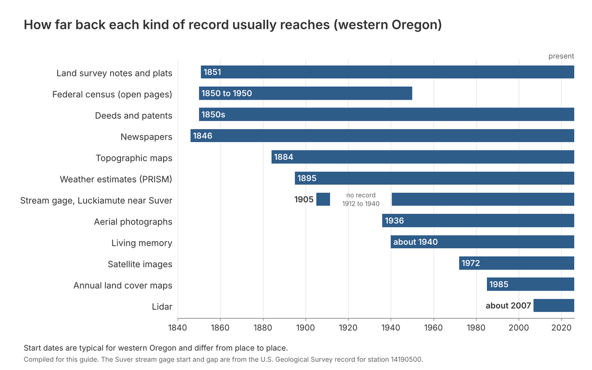
Figure 2.1. How far back each kind of record usually reaches in western Oregon. Before the 1850s the written record is thin; after the 1930s it is thick. Find the years your question is about, and read down the chart to see which kinds of record can help. Compiled for this guide. The stream gage dates are from the U.S. Geological Survey record for station 14190500, Luckiamute River near Suver.
Keep a research log from the first day
For every item you find, write down what it is, who made it, its date, where you found it, and the date you looked. Copy the exact words that matter. Then, in a separate line, write what you think they mean, and at least one other thing they could mean. Keeping the record's words apart from your reading of them is the most useful habit in this guide. Months later it lets you tell what you found from what you guessed.
A plain notebook or a simple spreadsheet is enough (Figure 2.2). Chapter 19 explains the log in full, and Chapter 24 has a form you can copy.
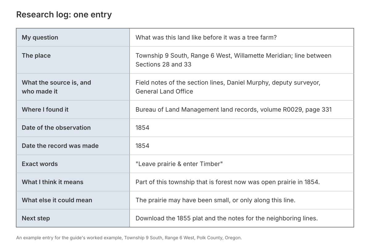
Figure 2.2. One entry in a research log. The surveyor's exact words sit in one row and the researcher's reading of them in another, with a second possible reading beside it. The last row says what to do next. Drawn for this guide from Daniel Murphy's field notes of 1854, Bureau of Land Management, Oregon land records, volume R0029, page 331.
On the tree farm
The owner's own files held a 2012 management plan and a 1993 survey of the land.2 The plan raised the first question: was the land really "homesteaded around the turn of the century"? The second question was older and wider: what grew there before the Douglas-fir?3 Each question pointed to a different record. A homestead leaves a federal patent, so the first question went to the Bureau of Land Management's patent records (Chapter 7). The second went to the survey notes of the 1850s. They gave the four words above, and on the same page, compass sightings on "Mr Tedroe's dwelling" and on a corner of Mr. Johnson's claim. Settlers were already living there when the surveyor came through.4 The log entry in Figure 2.2 records the first of those finds, and its last line says where the work went next: "Download the 1855 plat and the notes for the neighboring lines."
Notes
- Daniel Murphy, field notes of the section lines, T9S R6W, March 1854, BLM Oregon land records, vol. R0029, p. 331. Murphy wrote "prarie."
- Sullivan Tree Farm Management Plan (2012); Partition Plat No. 1993-0029, Polk County survey CS 12769; both listed in A History of the Land (2026), annotated bibliography.
- A History of the Land (2026), opening section.
- Murphy (1854), vol. R0029, p. 331.