
Chapter 1. Every piece of land has a story
For years the management plan for a 211-acre tree farm just west of Pedee, in the Coast Range foothills of Polk County, Oregon (Figure 1.1), said the land "was homesteaded around the turn of the century."1 It was a reasonable thing to believe, and it stood in the plan, unchallenged, for years.
In October 2026 a few evenings with public records told a different story. Homesteading accounts for about 7 of the farm's 211 acres. Most of the rest is two pioneer land claims surveyed in the summer of 1855, and much of what remains passed to a railroad under a federal land grant.2 In March 1854 a government surveyor walking the line between Sections 28 and 33, which runs through the farm, wrote "Leave prairie & enter Timber" in his notebook.3 And of the 23 trees that surveyors marked at corners on and near the farm in 1854 and 1855, 15 were oaks. Only one was a Douglas-fir.4
None of that was hidden. All of it was in public records, most of them free and online. It was scattered among offices and websites, written in old handwriting and old units, and filed by township and range rather than by address. This guide shows how to find records like these, read them, and put them together for your own land.
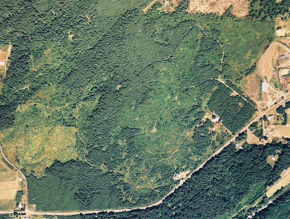
Figure 1.1. The Sullivan tree farm from the air, about 2002. Almost all of what you see inside the farm is Douglas-fir plantation, planted about 1976 and again in 1990. In 1955 most of the same ground was open grass with scattered trees; Chapter 22 follows the change through aerial photographs of 1936, 1955 and 1978. From the owner's files.
What a piece of land remembers
Every property has a past that is longer than its paperwork. Before the current deed there were earlier owners. Before them came the surveyors who first measured the land, and before the surveyors came the people who had lived in the country around it for thousands of years. Under all of that are the rock, the soil, the water and the weather, which decided what could grow there and what could be built.
A good history of a piece of land starts with the place as it is today, then goes back to the beginning and follows those layers, usually in this order:
- The ground. The rock underneath, the soil on top, the shape of the slopes.
- Water and weather. The streams and wells, the floods and the hard winters.
- The people before the surveyors. Who lived there before American settlement, and which nations are their descendants today.
- The surveyors. What the first government surveyors saw and wrote down.
- The first owners. How the land passed out of federal hands, to whom, and under which law.
- The families. Who owned it, lived on it and worked it afterward.
- Seen from above. What aerial photographs have shown since the 1930s.
- Getting there. The trails, roads and railroads that changed what the land was worth.
The website Your Land History tells its reports in the same order (Chapter 5), and Chapter 22 follows the tree farm through it from beginning to end.
What you can learn
With a few evenings of work, you can often learn:
- what the land is made of, and why its soil is what it is;
- what grew there before the present forest, field or lawn, and when that changed;
- which Native people lived in the valley, how the land passed out of their hands, and which tribes are their descendants today;
- when the land was first surveyed, and what the surveyor wrote about it;
- who first received title from the government, when, and under which law;
- what was built, farmed, logged or moved, and roughly when;
- what earlier owners and neighbors remember.
What this guide is not
This guide is about history. It can tell you who owned a piece of land in 1877. It cannot tell you who owns it now, where a boundary runs today, or whether anyone else has a right to cross it. Those are questions of title and survey, and they belong with a title company, a licensed surveyor or an attorney. Old records can explain a great deal about a property. They cannot settle a dispute about it.
What it costs
Most of the records in this guide are public, and most can be seen free online. Some need a free account, such as FamilySearch for census pages and filmed deed books. Some are kept in an office and cost a trip, a copy fee or a letter. A few cost real money. A scan of an old aerial photograph from the University of Oregon's collection, for example, cost $35 to set up an order plus $12 an image in October 2026.5 Each source in Part II says what it costs. The largest cost is time.
Four kinds of evidence
The evidence about any piece of land falls into four groups, and Part II takes them one at a time.
- Written documents. Survey notes, land patents (the government's first deeds), later deeds, tax rolls, census pages, newspapers, diaries and letters.
- Images. Survey maps (called plats), topographic maps, county atlases, photographs, aerial photographs and satellite images.
- The land itself. The rock, soil, water and climate of the place, what grows and lives on it, and the marks people left: old trees, stumps, fence lines, foundations and road grades.
- Living memory. What people who have known the place can tell you, and the papers and photographs families keep.
No single source gets the last word. Each record was made by one person, for one purpose, on one day. A surveyor in 1854 was measuring a line, not describing a farm. A county assessor was valuing a property, not dating its barn. The strongest answers come when sources that did not copy each other agree. When a traveler's journal, a surveyor's notes and an old neighbor's memory all describe the same open prairie, you can rely on it more than on any one of them. When they disagree, write the disagreement down, because it tells you where to look next.
Records also lead to each other. The township, range and section of your land open the survey notes and the patents. A patent names the first owner, and that name opens the deed index, the census and the cemetery records. A date in a deed sends you to the aerial photograph taken nearest that year. Chapter 19 follows the whole chain.
On the tree farm
On the farm near Pedee, three records made at different times, by different people, for different reasons, tell one story. The first is the surveyors' notes of the 1850s. In 1855 a deputy surveyor described one of the two land claims that cover most of the farm as valuable for "the timber on Luckiamute river and the rich prairie," and the trees he and the surveyor of 1854 marked at corners were mostly oaks: 15 of 23.6 (The township plat that letters "Level prairie and soil 1st rate" across Section 33 does not count as a second witness, because it was drawn from the same notes; see Figure 1.2.7) The second is an aerial photograph of 1955, which shows open grassland with scattered trees. The third is the owner's management plan, which says the land was fenced and grazed by cattle before he bought it.8 Today the farm is almost entirely Douglas-fir plantation, planted about 1976 and again in 1990.9 What kept the prairie open in the 1850s, and exactly when the trees closed in, the records gathered so far do not say.
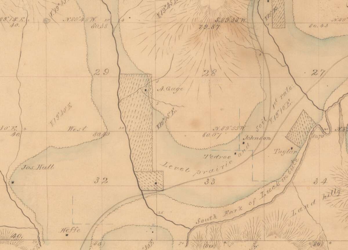
Figure 1.2. The first map of the place, 1855. Find the small black squares labeled "Tedroe," "Johnson" and "Taylor": settlers' houses that the surveyor sighted in March 1854. Then find "Level prairie and soil 1st rate" curving up from Section 33, where most of the farm lies. The large numbers are sections. The small figures along the lines, such as 80.07, are lengths in chains. General Land Office plat of Township 9 South, Range 6 West, Willamette Meridian, approved at Salem May 1, 1855 (detail). Bureau of Land Management, Oregon State Office. Public domain.
One farm runs through the whole guide
The running example is the Sullivan tree farm: about 211 acres of forest in Sections 28 and 33 of Township 9 South, Range 6 West, Willamette Meridian, in Polk County. It lies in the Coast Range foothills just west of the small community of Pedee. Monmouth is 15 miles to the northeast and Philomath 10 miles to the south. The west side of the farm drains to Pedee Creek and the east side straight to the Luckiamute River.10 Dave Sullivan bought it in December 1989.11
It was chosen because it is ordinary in the best way. It has the kinds of records much western Oregon land has: survey notes from the 1850s, land claims, a railroad grant, a homestead, aerial photographs from 1936 on, and a long gap in the middle where the deeds have not yet been traced. It also has an owner who agreed to have its story told in public, address and all: the farm is at 12875 Kings Valley Highway. Figure 1.3 shows where it is.
There is one more reason. The idea for the website Your Land History came from working out the history of this farm.12
Every chapter of this guide includes a box called "On the tree farm," which shows that chapter's method at work there. Two other places appear in Chapter 23, where the same method meets different records: a house in one of Albany's historic districts, where fire insurance maps and city directories lead the way, and a dryland wheat field near Moro, in Sherman County, where soils, rainfall and crop records lead.
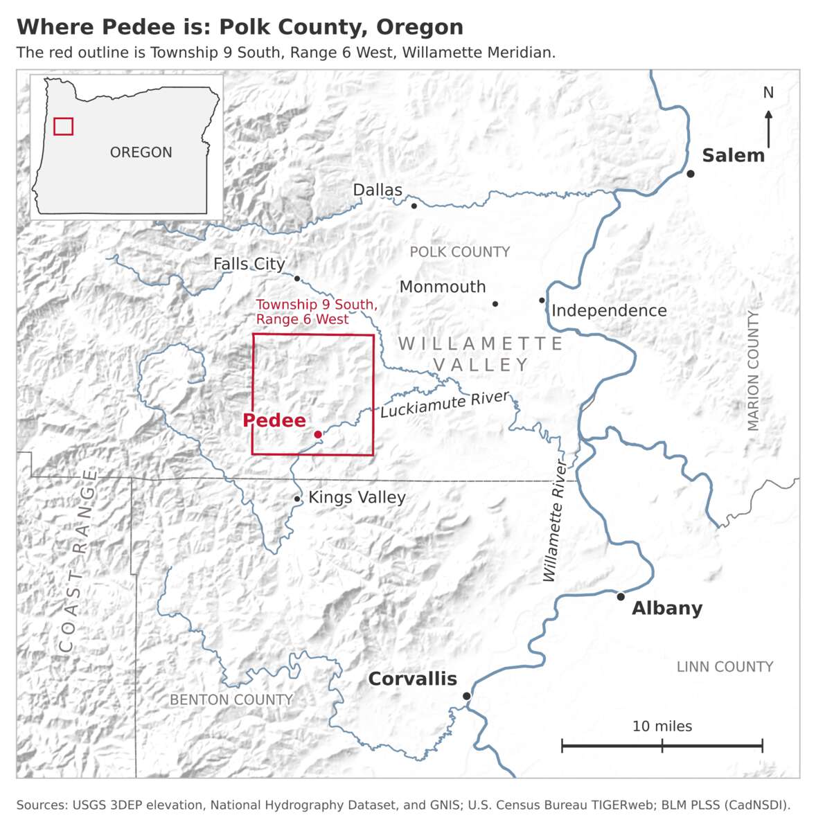
Figure 1.3. Where the running example is. The red square is Township 9 South, Range 6 West, a block of land 6 miles on a side in the Coast Range foothills of Polk County. The tree farm lies inside it, just west of Pedee on the Luckiamute River. Drawn for this guide from U.S. Geological Survey elevation, stream and place-name data, U.S. Census Bureau boundaries, and Bureau of Land Management survey-grid data.
Notes
- Sullivan Tree Farm Management Plan (2012), as quoted in A History of the Land: The Story of the Sullivan Tree Farm near Pedee, Polk County, Oregon (October 2026), opening section.
- A History of the Land (2026), "1871 to 1900: Railroad land and a seven-acre homestead," patent table, from Bureau of Land Management, General Land Office Records, and the BLM historical index for T9S R6W.
- Daniel Murphy, field notes of the section lines, T9S R6W, Willamette Meridian, March 1854, BLM Oregon land records, vol. R0029, p. 331. Murphy wrote "prarie."
- Murphy (1854); Thomas H. Hutchinson, field notes of the donation land claim surveys, T9S R6W, 1855, BLM Oregon land records, vol. D0022; tally of 23 bearing trees at 13 corners in A History of the Land (2026), "The witness trees."
- University of Oregon Libraries, Aerial Photography Research Service, fee schedule, checked October 10, 2026.
- Hutchinson (1855), vol. D0022, p. 351, on the Tedrow claim; Murphy (1854); tally in A History of the Land (2026), "The witness trees."
- General Land Office plat of T9S R6W, Willamette Meridian, approved May 1, 1855, BLM Oregon State Office; drawn from Murphy's notes, as A History of the Land (2026) explains in "1852 to 1854: The surveyors arrive and find neighbors."
- USDA aerial photograph of 1955, Oregon Digital; Sullivan Tree Farm Management Plan (2012); both as described in A History of the Land (2026), "The twentieth century, seen from the air."
- A History of the Land (2026), "The twentieth century, seen from the air" and "December 1989 to today."
- A History of the Land (2026), "The land today."
- Same.
- Dave Sullivan, October 10, 2026. The preface tells how the research began.